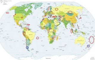
*For Wednesday, 18 October 2006.
LEGEND for OVERVIEW: Size = My surety of area for quake.
Red Circle = Probable quake to STRONG quake.
Triangle = Very Strong/Stronger quake (Usually takes extra days).
Blue Circle, etc. = Uncertainty of symptom area for probable quake.

Places to watch.
Good luck to all.
For Wednesday, 18 October 2006.
--------------------------------------
The Pyrenees (Felt volcanic - Strong)
--------------------------------------
2006-10-17 10:32:30.6 48.36N 6.66E 12f ML2.7 FRANCE
2006-10-19 22:53:27.8 42.00N 2.37E 25 ML3.0 PYRENEES
2006-10-19 16:15:05.5 46.81N 0.41E 10 ML2.8 FRANCE
2006-10-19 15:11:14.4 45.65N 6.92E 10 ML2.5 FRANCE
2006-10-19 12:06:54.2 48.95N 0.50E 10 ML2.8 FRANCE
2006-10-19 11:59:27.2 49.74N 2.75E 10 ML3.1 FRANCE
2006-10-19 07:07:09.6 46.24N 0.81E 2 ML2.8 FRANCE
Trinidade Island area (21.0S 30.0W)
--------------------------------------
4.6 2006/10/18 03:25:03 -21.538 -66.593 201.7 POTOSI, BOLIVIA
(Way off on longitude - I will try to watch for a repeat.)
Sumatra (Felt volcanic - Strong)
--------------------------------------
2006-10-18 02:01:24.8 1.37N 97.09E 33 mb5.1 NORTHERN SUMATERA, INDONESIA
The New Madrid Fault
--------------------------------------
3.4 2006/10/18 20:59:21 36.540 -89.640 7.7 4 km ( 2 mi) NW of Marston, MO
1.7 2006/10/18 22:08:22 36.060 -89.810 7.5 2 km ( 1 mi) N of Cooter, MO
1.6 2006/10/19 00:57:08 36.530 -89.640 7.1 3 km ( 2 mi) WNW of Marston, MO
1.6 2006/10/19 01:02:26 36.530 -89.640 7.6 3 km ( 2 mi) WNW of Marston, MO
1.5 2006/10/19 03:45:31 36.540 -89.640 8.0 4 km ( 2 mi) NW of Marston, MO
1.5 2006/10/19 04:10:18 36.540 -89.650 7.0 4 km ( 3 mi) NW of Marston, MO
1.8 2006/10/19 10:13:41 36.150 -89.470 14.2 13 km ( 8 mi) S of Ridgely, TN
Puerto Rico/Virgin Islands
--------------------------------------
1.9 2006/10/17 13:25:33 17.927N -66.819W 10.4 7 km ( 5 mi) S of Indios, PR
3.2 2006/10/17 02:53:53 18.218N -68.190W 150.8 71 km (44 mi) SE of Higüey, La Altagracia, Dominican Republic
2.4 2006/10/17 00:49:15 18.089N -66.120W 6.7 5 km ( 3 mi) SSW of G. L. García, PR
Mt. St. Helen’s
--------------------------------------
1.3 2006/10/18 09:41:33 46.196 -122.197 0.9 1 km ( 1 mi) WSW of Mount St. Helens Volcano, WA
1.9 2006/10/18 09:29:22 46.195 -122.191 0.0 1 km ( 1 mi) WSW of Mount St. Helens Volcano, WA
2.4 2006/10/18 05:01:04 46.195 -122.193 0.3 1 km ( 1 mi) WSW of Mount St. Helens Volcano, WA
Northcentral Iran
--------------------------------------
2006-10-18 01:34:52.3 30.90N 56.76E 10 M3.0 CENTRAL IRAN
Honshu Japan
--------------------------------------
(Nothing found)
URAL MOUNTAINS, RUSSIA, REGION
(53.73N 59.72E) (MEDIUM)
--------------------------------------
NORTHWESTERN SIBERIA, RUSSIA
Origin time Lat Lon Azres Timres Wres Nphase Ntot Nsta Netmag
2006-290:16.34.09.0 68.61 68.06 12.84 0.62 3.83 3 3 2 3.26
(Off by 10 on both longitude and lattitude.)
2006-10-20 09:26:07.0 54.92N 58.68E ML3.2 URAL MOUNTAINS REGION, RUSSIA
South of the Aleutians
--------------------------------------
3.7 2006/10/18 02:32:26 57.560 -137.186 1.0 OFF THE COAST OF SOUTHEASTERN ALASKA
2.6 2006/10/18 21:12:25 59.934 -147.904 30.0 GULF OF ALASKA
(Much further east than expected.)
Mongolia/Lake Baikal, Russia area
(Strong)
--------------------------------------
2006-10-18 06:22:08.3 50.37N 91.45E 15 Ms3.3 TUVA-BURYATIA-MONGOLIA BDR REG
Possibly Mt. Etna (Felt volcanic - Strong)
--------------------------------------
(Nothing found but Mt. Etna continues to ooze lava. Very spectacular at night.)

Turkey (Medium)
--------------------------------------
2006-10-18 05:27:43.4 39.80N 36.66E 5 MD3.3 CENTRAL TURKEY
2006-10-18 07:49:32.1 38.49N 43.49E 8 MD2.7 EASTERN TURKEY
2006-10-18 13:33:23.4 41.62N 34.87E 22 MD2.7 CENTRAL TURKEY
2006-10-18 23:43:30.4 38.56N 43.55E 2 ML3.7 EASTERN TURKEY
2006-10-19 22:19:28.5 39.94N 40.76E 5 ML3.8 EASTERN TURKEY
2006-10-19 22:05:20.4 39.89N 40.81E 13 MD2.8 EASTERN TURKEY
2006-10-19 21:22:14.3 39.88N 40.81E 16 MD2.8 EASTERN TURKEY
2006-10-19 21:00:47.1 39.86N 40.78E 5 Mw4.4 EASTERN TURKEY
2006-10-19 04:36:28.7 39.81N 32.74E 2 MD3.1 CENTRAL TURKEY
Possibly OFFSHORE LOS LAGOS, CHILE
(-42.811 -74.175) (Second day
symptom - STRONG.)
--------------------------------------
17/10/2006 07:54:46 -28.233 -70.186 85.9 4.9Ml GUC 67 km al NE de Vallenar INFORME
17/10/2006 01:02:37 -20.967 -68.283 139.7 5.7Mb NEIC 28 km al N de Ollague
(Off on coordinates. Another symptom that seems to be unstable - I will watch for repeats.)
Peru (Non-specific)
--------------------------------------
2006-10-20 10:48:57 5.8 13.54S 76.70W 34 Near Coast of Peru
2006-10-20 20:20:41 5.3 9.74S 74.83W 122 Central Peru
(2 extra days)
The Geysers
--------------------------------------
1.7 2006/10/19 15:45:23 38.829 -122.871 1.5 7 km ( 4 mi) WNW of The Geysers, CA
1.3 2006/10/19 15:36:56 38.797 -122.799 0.1 1 km ( 0 mi) ESE of The Geysers, CA
1.4 2006/10/19 15:29:19 38.826 -122.865 0.4 6 km ( 4 mi) WNW of The Geysers, CA
1.2 2006/10/19 07:46:15 38.805 -122.793 1.1 1 km ( 1 mi) ENE of The Geysers, CA
1.5 2006/10/19 06:04:55 38.826 -122.865 0.9 6 km ( 4 mi) WNW of The Geysers, CA
1.1 2006/10/19 01:58:00 38.827 -122.804 2.9 3 km ( 2 mi) N of The Geysers, CA
2.3 2006/10/18 16:31:23 38.806 -122.792 1.4 2 km ( 1 mi) ENE of The Geysers, CA
1.4 2006/10/18 12:27:56 38.830 -122.799 0.1 4 km ( 2 mi) N of The Geysers, CA
2.1 2006/10/18 12:27:19 38.827 -122.796 1.0 3 km ( 2 mi) NNE of The Geysers, CA
1.8 2006/10/18 10:48:16 38.827 -122.773 1.8 4 km ( 3 mi) NE of The Geysers, CA
2.1 2006/10/17 21:10:05 38.809 -122.796 4.5 1 km ( 1 mi) NE of The Geysers, CA
1.1 2006/10/17 18:06:01 38.827 -122.798 3.2 3 km ( 2 mi) NNE of The Geysers, CA
1.8 2006/10/17 17:02:54 38.825 -122.802 1.9 3 km ( 2 mi) N of The Geysers, CA
Possibly New Zealand
--------------------------------------
2006-10-16 00:35:33.2 50.73S 162.24E 10G M5.8 AUCKLAND ISLANDS, N.Z. REGION
(2 days early)
Fiji to Kermadec Islands area
--------------------------------------
2006-10-17 11:07:01 5.6 23.84S 179.98W 433 South of Fiji Islands
2006-10-17 14:39:21 5.1 17.77S 177.48W 35 Fiji Islands Region
2006-10-17 15:39:07 5.0 24.33S 179.75W 337 South of Fiji Islands
Peace to all.

