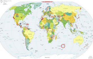
*For Sunday, 1 October 2006.
LEGEND for OVERVIEW: Size = My surety of area for quake.
Red Circle = Probable quake to STRONG quake.
Triangle = Very Strong/Stronger quake (Usually takes extra days).
Blue Circle, etc. = Uncertainty of symptom area for probable quake.

Places to watch.
Good luck to all.
For Sunday, 1 October 2006.
---------------------------------------
Lake Nacimiento area (35.637°N, 120.920°W)
---------------------------------------
2.2 2006/10/01 15:14:40 35.717 -121.087 6.8 12 km ( 8 mi) NE of San Simeon, CA
1.8 2006/10/01 20:09:20 35.738 -120.288 8.2 12 km ( 8 mi) NE of Shandon, CA
The Parkfield Fault/Pinnacles area (medium)
---------------------------------------
1.0 2006/10/01 03:53:47 37.141 -121.534 8.7 8 km ( 5 mi) NE of San Martin, CA
1.1 2006/10/01 05:18:30 37.052 -121.477 6.0 10 km ( 6 mi) ENE of Gilroy, CA
1.0 2006/10/01 07:00:09 37.257 -121.640 2.4 14 km ( 9 mi) N of Morgan Hill, CA
Yucca Valley area (34.212°N, 116.435°W)
---------------------------------------
1.6 2006/10/01 10:24:23 34.181 -116.445 6.2 7 km ( 4 mi) NNW of Yucca Valley, CA
3.0 2006/10/02 15:44:45 34.350 -116.463 5.3 25 km ( 16 mi) N of Yucca Valley, CA
Montana
---------------------------------------
1.2 2006/10/01 13:37:18 44.694 -110.021 13.0 37km(23 mi)S of Cooke City-Silver Gate, MT
2.3 2006/10/01 14:44:08 44.685 -110.015 12.8 37km(23 mi)S of Cooke City-Silver Gate, MT
Southern Mexico/then possibly Yucatan area
---------------------------------------
2006/10/01 01:59:50 16.11 94.55 60 4.8 50 km al SURESTE de UNION HIDALGO, OAX
2006/10/01 16:51:48 16.78 99.76 5 3.9 18 km al SURESTE de ACAPULCO, GRO
2006/10/02 20:48:55 16.19 98.23 5 4.0 25 km al SUROESTE de PINOTEPA NACIONAL, OAX
2006/10/02 22:24:08 16.00 97.51 16 3.9 9 km al OESTE de RIO GRANDE, OAX
Puerto Rico/Virgin Islands (Medium)
---------------------------------------
2.1 2006/10/01 19:08:59 17.854N -66.987W 13.0 15 km ( 9 mi) SSE of La Parguera, PR
1.9 2006/10/01 07:23:21 17.828N -66.128W 19.1 15 km ( 9 mi) SSE of Jobos, PR
1.8 2006/10/01 00:56:31 17.891N -66.969W 29.7 10 km ( 7 mi) SSW of Guánica, PR
Canby, Oregon area (45.304 -122.362)
(Medium)
---------------------------------------
1.8 2006/10/02 14:57:00 46.890 -122.498 0.0 10 km ( 6 mi) SE of Yelm, WA
1.0 2006/10/02 11:48:32 46.867 -121.909 11.3 15 km ( 9 mi) NE of Ashford, WA
North of Svalbard (Strong)
---------------------------------------
SENJA FRACTURE ZONE
Origin time Lat Lon Azres Timres Wres Nphase Ntot Nsta Netmag
2006-273:11.58.33.0 72.52 12.02 11.50 0.14 3.02 2 2 1 2.00
KNIPOVICH REGION
Origin time Lat Lon Azres Timres Wres Nphase Ntot Nsta Netmag
2006-273:18.30.15.0 75.81 8.33 4.32 0.71 1.79 3 9 2 2.33
STORFJORDEN-HEER LAND SVALBARD
Origin time Lat Lon Azres Timres Wres Nphase Ntot Nsta Netmag
2006-274:06.27.35.0 77.98 16.61 13.87 4.84 8.31 3 3 2 2.52
Issaquah, WA (47.514N 122.028W)
(Medium)
---------------------------------------
1.9 2006/10/01 21:21:28 47.561 -121.391 10.1 17 km ( 10 mi) S of Skykomish, WA
1.1 2006/10/01 20:56:18 47.954 -121.590 12.7 13 km ( 8 mi) NNE of May Creek, WA
1.3 2006/10/01 20:49:51 47.948 -121.575 10.9 13 km ( 8 mi) NE of May Creek, WA
1.4 2006/10/01 20:47:59 47.950 -121.592 11.6 12 km ( 8 mi) NNE of May Creek, WA
2.5 2006/10/01 20:43:36 47.944 -121.582 8.9 12 km ( 7 mi) NE of May Creek, WA
The New Madrid Fault (Medium)
---------------------------------------
1.8 2006/10/01 23:16:17 36.270 -89.500 7.4 2 km ( 1 mi) WNW of Ridgely, TN
1.7 2006/10/02 04:23:23 36.550 -89.660 10.2 6 km ( 4 mi) NW of Marston, MO
Eastern Siberia, Russia
---------------------------------------
(Nothing found)
Strait of Gibralta/Morocco area
---------------------------------------
2006-10-01 08:44:34.1 35.03N 2.99W 10 mb3.5 STRAIT OF GIBRALTAR
NORTHERN XINJIANG, CHINA (44.74N 81.58E)
---------------------------------------
2006-10-01 05:37:10.0 37.83N 73.89E ML3.5 TAJIKISTAN
2006-10-01 10:43:40.0 39.59N 73.77E ML3.4 TAJIKISTAN-XINJIANG BORDER REG
Mid-Indian Ridge area (-40.131 78.473)
(MEDIUM)
---------------------------------------
2006-10-05 14:41:53.0 37.44S 51.35E 33 mb4.9 SOUTH INDIAN OCEAN
(4 extra days)
2006-10-06 05:08:51.3 41.23S 80.67E 10f Mw5.7 MID-INDIAN RIDGE
(5 extra days)
Costa Rica/Nicaragua area
---------------------------------------
06/10/01 20:18:22 12.18N 86.90W 111.1 2.5MC Frente a Puerto Sandino
06/10/01 19:19:58 10.95N 86.87W 17.6 3.5MC Frente a La Boquita y Casares
06/10/01 13:42:17 11.82N 87.63W 1.0 2.7ML Frente a Corinto
06/10/01 12:42:25 11.60N 85.79W 12.4 1.8ML Cerca de Isla de Zapatera
06/10/01 08:41:58 10.77N 87.83W 173.8 4.1ML Oceano Pacífico de Nicaragua
06/10/01 04:16:04 11.65N 87.09W 55.2 3.2ML Frente a Puerto Sandino
06/10/01 01:01:34 12.66N 87.60W 4.7 1.7ML Frente al Cosigüina
06/09/30 22:11:57 12.14N 88.11W 1.0 2.7ML Oceano Pacífico de Nicaragua
Northcentral Iran
---------------------------------------
2006-10-02 03:13:22.7 35.66N 59.08E 7 M3.1 NORTHERN AND CENTRAL IRAN
2006-10-02 14:43:24.4 31.79N 56.06E 3 M3.2 NORTHERN AND CENTRAL IRAN
Possibly Yellowstone, Wyoming area
(New symptom felt volcanic - Strong)
---------------------------------------
(Nothing found)
Peace to all.

