*For Sunday, 26 March 2006.
LEGEND for OVERVIEW: Size = My surety of area for quake.
Red Circle = Probable quake to STRONG quake.
Triangle = Very Strong or Stronger quake (And usually takes extra days).
Blue Circle, etc. = Uncertainty of symptom area for probable quake.
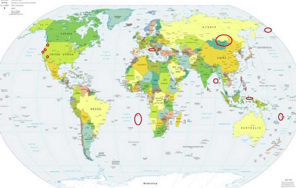
Places to watch.
Good luck to all.
For Sunday, 26 March 2006.
----------------------------------------
Italy/Adriatic Sea area
----------------------------------------
2006-03-27 08:04:46 4.3 44.37 N 11.22 E Northern Italy
Vanuatu Islands (14.86 S 167.90 E) (Medium)
----------------------------------------
2006-03-24 23:30:49 5.4 13.72 S 167.84 E Vanuatu Islands
(2 days early)
MAP 4.4 2006/03/26 22:57:17 -20.214 169.339 96.1 VANUATU
Andaman Islands (11.72 N 94.21 E) (MEDIUM)
----------------------------------------
(Nothing found)
Lake Baykal, Russia into Mongolia/China area
----------------------------------------
2006-03-26 19:20:44 5.0 34.17 N 104.39 E Gansu, China
(Even more south than I thought.)
South Atlantic Ocean (25.84S 2.48W) (Strong)
----------------------------------------
2006-03-27 01:10:35 5.1 7.19 N 34.40 W Central Mid Atlantic Ridge
(This may be the quake for this symptom - I will have to watch for a repeat.)
The Geysers
----------------------------------------
MAP 2.4 2006/03/25 17:17:47 38.794 -122.778 2.3 3 km ( 2 mi) E of The Geysers, CA
MAP 1.7 2006/03/25 18:56:55 38.817 -122.812 1.2 2 km ( 1 mi) NNW of The Geysers, CA
MAP 2.2 2006/03/26 17:48:51 38.809 -122.798 3.6 1 km ( 1 mi) NNE of The Geysers, CA
MAP 1.5 2006/03/26 19:24:48 38.806 -122.796 4.0 1 km ( 1 mi) NE of The Geysers, CA
Hydesville, California area (40.553 -123.829)
----------------------------------------
MAP 2.4 2006/03/26 14:47:06 40.097 -123.684 19.7 12 km ( 8 mi) ESE of Redway, CA
Mt. St. Helen’s
----------------------------------------
MAP 1.2 2006/03/25 15:32:03 46.196 -122.187 0.0 1 km ( 0 mi) SW of Mount St. Helens Volcano, WA
MAP 2.7 2006/03/25 15:42:18 46.197 -122.190 0.2 1 km ( 1 mi) WSW of Mount St. Helens Volcano, WA
Bering Sea area (58.34 N 177.54 E)
----------------------------------------
2006-03-28 18:36:53.1 76.63N 129.77E 10 f mb4.5 LAPTEV SEA?
(2 days extra and off on location some - I will watch for a repeat.)
Northern Molucca Sea area (2.4N 126.9E) (Medium)
----------------------------------------
2006-03-26 09:21:56.2 7.10S 128.44E 100 mb4.9 BANDA SEA
Joseco, Nevada area (37.652 -114.180) (Strong)
----------------------------------------
MAP 1.2 2006/03/27 01:09:11 37.389 -117.078 0.0 19 km ( 12 mi) ENE of Tokop, NV
MAP 1.2 2006/03/27 10:23:22 37.434 -117.078 5.4 22 km ( 14 mi) NE of Tokop, NV
MAP 1.8 2006/03/27 23:48:52 35.914 -114.782 0.0 10 km ( 6 mi) ESE of Boulder City, NV
Peace to all.

posted by Unknown @ 11:40 AM
0 comments
![]()
![]()
