*For Monday, 24 April 2006.
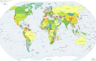
LEGEND for OVERVIEW: Size = My surety of area for quake.
Red Circle = Probable quake to STRONG quake.
Triangle = Very Strong or Stronger quake (And usually takes extra days).
Blue Circle, etc. = Uncertainty of symptom area for probable quake.

Places to watch.
Good luck to all.
For Monday, 24 April 2006.
----------------------------------------
XIZANG-QINGHAI BORDER REGION (32.739 93.536) (Very Strong)
livescience

----------------------------------------
2006-04-23 17:24:36 4.5 42.58 N 83.72 E Northern Xinjiang, China
Mt. St. Helen’s to Mt. Hood area (Medium)
----------------------------------------
MAP 2.7 2006/04/24 06:03:29 46.199 -122.178 0.0 0 km ( 0 mi) SE of Mount St. Helens Volcano, WA
Mt. San Gorgonio, California (34.019 -116.774) (Medium)
----------------------------------------
MAP 1.4 2006/04/23 15:54:52 34.035 -116.759 18.1 10 km ( 6 mi) SE of Mt. San Gorgonio, CA
MAP 1.2 2006/04/23 23:06:49 33.881 -116.829 13.7 7 km ( 4 mi) WSW of Cabazon, CA
MAP 1.5 2006/04/24 00:38:56 33.967 -116.687 19.2 10 km ( 6 mi) NE of Cabazon, CA
Western Lofoton Basin (69.76 6.87) then closer to North Sea
----------------------------------------
(Nothing found)
France/Spain border
----------------------------------------
2006-04-23 06:52:31.2 43.72 N 8.88 W 12 ML 3.8 SPAIN
2006-04-23 05:41:23.7 43.66 N 8.91 W 10 ML 3.6 SPAIN
2006-04-23 05:31:35.4 43.72 N 9.04 W 10 ML 4.8 SPAIN
2006-04-24 11:48:04.9 43.97 N 9.04 E 2 ML 3.4 CORSICA, FRANCE
2006-04-25 06:59:22.6 45.91 N 2.43 E 2 ML 2.8 FRANCE
2006-04-25 14:14:06.2 47.83 N 0.70 W 10 ML 2.7 FRANCE
Colombia-Venezuela border area (7.021 -72.749) (STRONG)
----------------------------------------
(Nothing found)
Puerto Rico/Virgin Islands area (Medium)
----------------------------------------
MAP 2.9 2006/04/24 01:43:47 18.156 -65.928 68.7 5 km ( 3 mi) SE of San Lorenzo, PR
MAP 3.1 2006/04/24 02:13:16 19.138 -64.583 3.2 53 km ( 33 mi) NNW of Settlement, British Virgin Islands
Weaverville, California area (40.810 -122.947)
----------------------------------------
MAP 2.2 2006/04/23 17:51:50 40.246 -122.251 26.0 8 km ( 5 mi) N of Red Bluff, CA
MAP 2.4 2006/04/24 14:51:09 39.293 -122.929 8.6 13 km ( 8 mi) S of Lake Pillsbury, CA
MAP 1.4 2006/04/25 02:01:08 40.022 -122.950 2.9 35 km ( 22 mi) NE of Covelo, CA
MAP 2.1 2006/04/25 02:00:27 40.054 -122.945 0.0 38 km ( 24 mi) NE of Covelo, CA
James Bay, Canada area (53.51N 81.86W) (This may not be a quake - I felt COLDNESS.)
----------------------------------------
2006/04/25 09:16:12 73.44N 72.34W 18.0g 2.3ML GSC BAFFIN BAY SEISMIC ZONE.
2006/04/25 17:24:28 73.39N 73.58W 18.0g 2.2ML GSC BAFFIN BAY SEISMIC ZONE.
2006/04/25 22:25:57 68.79N 89.49W 18.0g 1.7MN GSC 31 km NE from Kugaaruk, NU
(Not very close.)
Peace to all.

