*For Sunday, 26 February 2006.
LEGEND for OVERVIEW:
Size = My surety of area for quake.
Red Circle = Probable quake to STRONG quake.
Triangle = Very Strong or Stronger quake (And usually takes extra days).
Blue Circle, etc. = Uncertainty of symptom area for probable quake.

Places to watch.
Good luck to all.
For Sunday, 26 February 2006.
----------------------------------------
Mozambique
----------------------------------------
24Feb2006 23:24:42.2 21.3S 33.5E 33 MS=4.1 M*GSR MOZAMBIQUE
(2 days early)
Date: February 25, 2006 at 21:06:31
From: From Cathy Buckle
Subject: The Earth Moved
From : Cathy Buckle
Sent : Saturday, February 25, 2006 10:04 AM
To : African Tears
Subject : The Earth Moved
Dear Family and Friends,
Something amazing happened in Zimbabwe this week. On Wednesday night at 20
minutes past midnight the earth shook for a few minutes. The earthquake which
measured 7.5 on the Richter scale was centred in Espungabera, a small farming
town in a remote area of Mozambique near the Zimbabwe border. The earthquake was
felt as far as 1000 kilometres away from the epicentre. In north east Zimbabwe
beds shook, furniture trembled and glasses and plates tinkled on shelves in
cupboards. Many of us heard a rushing noise like a high wind just as the shaking
started and had no idea about what to do or where to go to be safe. It was a
confusing and frightening experience, exacerbated by our ignorance as
earthquakes are virtually unknown in Zimbabwe.
At 6am the following morning, the obvious place to get news and information
about the strange shaking in the night, was the state owned radio and
television. I listened in confusion and disbelief as the headline morning news
wasn't about an earthquake, tremors or shaking but about the "unbundling" of Air
Zimbabwe into six individual companies. This "unbundling" is the latest
phenomenon of loss making government companies here. Instead of being closed
down or privatized, these huge debt ridden establishments are split up into
lots of different little companies. 'Unbundling' is the 'Zim-glish' word that
had sprung up to describe this strange activity which I suppose is undertaken to
share the debts and make the losses look smaller than they actually are. The
second story on the first news bulletin of the day was about some scandal with a
stripper on Valentines Day and still not about an earthquake and so I gave up
and went looking for news elsewhere.
For one day, we had something else to talk about in Zimbabwe, something other
than massive price rises and inflation that is going up faster than anyone can
cope with. In queues everywhere, whether for passport forms, cash machines or
petrol, a strange shaking in the middle of the night was the only topic of
conversation and it brought Zimbabweans together. Everyone, everywhere was
talking about the earthquake but by lunch time it was still not making headline
news on state owned television which was now talking about bumper harvests and
the Presidents 82nd birthday party. On Thursday evening, 18 hours after the
earthquake, I was forced to give up trying to find out about the tremors as the
electricity had gone off - again. A lot of people were worried about aftershocks
but we were mostly in the dark - literally and figuratively. For six hours the
next night, sitting in the dark with only the sound of hordes of screeching
mosquitoes it was hard not to think scary and superstitious thoughts as we
waited for more shaking. When the power did finally come back on the television
was again talking about the the nationwide celebrations planned to commemorate
President Mugabe's 82nd birthday party. It seems that even the earth moving does
match the importance of birthdays. Until next week, love cathy
Copyright cathy
buckle 25th February 2006 http://africantears.netfirms.com
Possibly Ascension Island
----------------------------------------
2006-02-26 18:42:44 5.1 32.39S 32.91W South Atlantic Ocean
(Much further South than expected but it was a non-specific symptom)
Nicaragua/Costa Rica border area (medium)
----------------------------------------
2006-02-24 23:38:32.3 9.58N 82.85W 30f mb5.0 PANAMA-COSTA RICA BORDER REGION
(2 days early)
06/02/26 16:41:29 11.72N 87.69W 15.0 3.1MC Frente a Corinto
06/02/26 13:37:15 12.01N 86.78W 78.5 2.7MC Frente a Puerto Sandino
06/02/26 11:43:18 11.46N 85.87W 173.1 3.6MC Rivas
06/02/26 11:25:24 12.10N 87.25W 24.0 2.9MC Frente a Poneloya
06/02/26 10:30:09 12.73N 86.99W 2.9 3.0MC Cerca del Volcan San Cristóba
06/02/26 06:32:06 13.23N 87.71W 7.0 3.3MC Golfo de Fonseca
06/02/26 05:48:08 13.34N 88.49W 1.0 2.7ML El Salvador
06/02/26 04:08:45 13.70N 88.02W 19.9 2.7ML El Salvador
Poland/Germany (medium)
----------------------------------------
2006-02-26 03:08:01.9 51.40N 15.96E 10 ML2.9 POLAND
2006-02-26 10:23:41.0 49.50N 7.00E 10G ML2.1 GERMANY
2006-02-26 18:27:13.0 49.40N 7.00E 10G ML2.3 GERMANY
2006-02-27 16:47:04.9 51.54N 16.01E 2 ML3.0 POLAND
Utah (STRONG)
----------------------------------------
map 1.3 2006/02/26 19:15:12 38.992N 111.323W 8.9 10 km ( 6 mi) NW of Emery, UT
map 1.4 2006/02/26 16:56:10 39.409N 111.216W 2.5 24 km (15 mi) WNW of Huntington, UT
map 1.6 2006/02/26 10:56:43 39.410N 111.219W 6.0 24 km (15 mi) WNW of Huntington, UT
map 1.2 2006/02/27 23:47:06 39.417N 111.215W 4.0 24 km (15 mi) WNW of Huntington, UT
map 1.8 2006/02/27 22:53:07 39.670N 110.524W 1.1 16 km (10 mi) NW of E. Carbon City, UT
map 1.7 2006/02/27 18:15:49 39.669N 110.513W 2.0 16 km (10 mi) NNW of E. Carbon City, UT
map 1.8 2006/02/27 15:40:47 39.669N 110.515W 1.8 16 km (10 mi) NNW of E. Carbon City, UT
map 2.2 2006/02/27 14:15:51 39.608N 110.400W 1.4 6 km ( 4 mi) N of Sunnyside, UT
map 1.3 2006/02/27 13:26:20 38.952N 112.960W 3.2 48 km (30 mi) WNW of Kanosh, UT
map 1.5 2006/02/27 09:13:43 39.672N 110.518W 1.4 16 km (10 mi) NNW of E. Carbon City, UT
map 1.6 2006/02/27 08:29:49 39.417N 111.213W 4.8 24 km (15 mi) WNW of Huntington, UT
map 1.6 2006/02/27 08:27:04 39.672N 110.512W 2.0 16 km (10 mi) NNW of E. Carbon City, UT
map 1.6 2006/02/27 02:32:01 37.536N 112.511W 7.9 31 km (19 mi) NNE of Orderville, UT
Los Angeles area (medium)
----------------------------------------
MAP 1.2 2006/02/25 19:16:58 33.849 -117.490 1.4 3 km ( 2 mi) ENE of El Cerrito, CA
MAP 1.7 2006/02/25 23:02:03 34.277 -118.425 7.6 1 km ( 1 mi) ESE of Pacoima, CA
MAP 1.3 2006/02/26 00:00:56 34.142 -117.467 11.7 5 km ( 3 mi) N of Fontana, CA
MAP 1.3 2006/02/26 00:37:56 37.078 -121.899 15.0 9 km ( 5 mi) NNW of Day Valley, CA
MAP 1.3 2006/02/26 21:02:03 34.120 -118.279 3.2 2 km ( 1 mi) E of Griffith Observatory, CA
Mid-Indian Ridge (24.34S 70.27E) (Strong)
----------------------------------------
25Feb2006 13:07:42.5 20.3S 67.7E 33 mb=5.1 M*GSR MID-INDIAN RIDGE
Parkfield Fault
----------------------------------------
MAP 1.3 2006/02/26 00:37:56 37.078 -121.899 15.0 9 km ( 5 mi) NNW of Day Valley, CA
MAP 1.4 2006/02/26 01:49:49 36.965 -121.598 4.8 6 km ( 3 mi) SSW of Gilroy, CA
MAP 1.2 2006/02/26 13:36:54 36.582 -121.178 3.4 6 km ( 4 mi) NNW of Pinnacles, CA
MAP 1.3 2006/02/26 19:03:43 36.619 -121.084 9.6 11 km ( 7 mi) NNE of Pinnacles, CA
MAP 1.7 2006/02/26 22:59:12 36.962 -121.595 5.3 6 km ( 4 mi) SSW of Gilroy, CA
Central Italy (2 different symptoms - Strong)
----------------------------------------
2006-02-26 11:07:27.0 42.59N 13.07E 11 ML2.9 CENTRAL ITALY
Honshu, Japan and south of (This was a very long drawn out symptom not several over the day - VERY STRONG.)
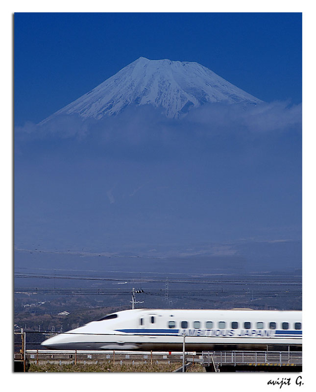
http://www.trekearth.com/members/avijitg/>Trekearth.com
Picture of Mt. Fuji and bullet train by Avijit Ghosh.
----------------------------------------
2006-02-24 16:29:37.5 33.21N 141.18E 65 M4.5 OFF EAST COAST OF HONSHU, JAPAN
(2 days early)
2006-02-27 09:10:54.0 26.82N 127.68E 33 mb5.2 RYUKYU ISLANDS, JAPAN
Afghanistan-Tajikistan border region (37.51N 69.11E) (Medium)
----------------------------------------
2006-02-26 04:35:35.9 36.38N 69.89E 150 mb4.2 HINDU KUSH, AFGHANISTAN, REG
Turkey
----------------------------------------
26.02.2006 10:46:45 38.469N 26.231E 28.9 3.1 KUCUKBAHCE ACIKLARI-IZMIR (EGE DENIZI)
26.02.2006 09:16:19 38.188N 26.752E 19.0 3.0 SEFERIHISAR ACIKLARI-IZMIR (EGE DENIZI)
26.02.2006 07:12:49 39.314N 40.179E 13.9 3.3 YAYLADERE (BINGOL)
26.02.2006 00:01:30 39.181N 29.470E 10.1 3.5 ORENCIK-EMET (KUTAHYA)
Sumatra (Medium)
----------------------------------------
2006-02-26 21:32:49 5.3 5.94N 94.67E Northern Sumatra, Indonesia
The New Madrid Fault
----------------------------------------
map 1.5 2006/02/26 05:47:23 36.490N 89.560W 8.1 11 km ( 7 mi) SSW of New Madrid, MO
Puerto Rico
----------------------------------------
map 2.7 2006/02/26 15:12:44 18.172N -67.390W 49.9 23 km (14 mi) SW of Stella, PR
map 2.5 2006/02/26 06:26:00 18.114N -66.075W 23.5 3 km ( 2 mi) ESE of G. L. García, PR
map 2.3 2006/02/26 05:54:52 18.170N -66.701W 20.4 3 km ( 2 mi) ENE of Adjuntas, PR
map 2.5 2006/02/26 03:41:02 18.699N -66.457W 58.2 27 km (17 mi) N of Tierras Nuevas Poniente, PR
Northern Xinjiang, China area (43.63N 84.13E) (Medium)
----------------------------------------
2006-02-25 09:12:42.0 40.74N 84.56E ML3.4 SOUTHERN XINJIANG, CHINA
2006-02-25 08:27:22.0 38.47N 80.57E ML3.4 SOUTHERN XINJIANG, CHINA
2006-02-25 14:09:34.0 40.62N 80.09E ML3.4 SOUTHERN XINJIANG, CHINA
2006-02-25 15:23:34.0 44.52N 85.49E ML3.0 NORTHERN XINJIANG, CHINA
2006-02-25 17:15:03.0 43.41N 86.15E ML3.0 NORTHERN XINJIANG, CHINA
2006-02-26 02:13:55.5 35.33N 89.47E 60 mb5.1 XIZANG
Ethiopia (11.73N 42.99E) (Unusual pressure - don't know what it means.)
----------------------------------------
2006-02-27 08:02:09 4.7 25.90 N 55.80 E Eastern Arabian Peninsula
Mariana Islands (Medium)
----------------------------------------
2006-02-25 14:03:01.1 13.45N 144.58E 81 M4.5 MARIANA ISLANDS
25Feb2006 14:49:40.2 12.2N 141.4E 50 MS=4.8 M*GSR SOUTH OF MARIANA ISLANDS
Hawaii
----------------------------------------
MAP 2.4 2006/02/25 00:27:55 19.337 -155.203 8.3 13 km ( 8 mi) SSE of Volcano, HI
MAP 2.0 2006/02/25 18:27:53 20.079 -155.335 11.9 5 km ( 3 mi) NE of Paauilo, HI
MAP 2.2 2006/02/26 07:27:09 19.383 -155.285 2.6 9 km ( 6 mi) SW of Volcano, HI
MAP 2.5 2006/02/26 17:33:18 20.026 -156.567 0.0 68 km ( 42 mi) WNW of Kalaoa, HI
Peace to all.

posted by Unknown @ 2:36 PM
0 comments
![]()
![]()
