*For Tuesday, 14 March 2006.
LEGEND for OVERVIEW:
Size = My surety of area for quake.
Red Circle = Probable quake to STRONG quake.
Triangle = Very Strong or Stronger quake (And usually takes extra days).
Blue Circle, etc. = Uncertainty of symptom area for probable quake.
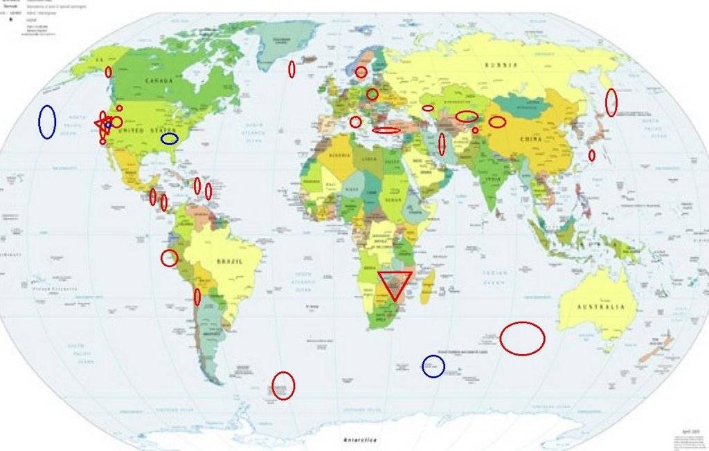
Places to watch.
Good luck to all.
For Tuesday, 14 March 2006.
(This seems to be the longest list of places I have ever felt symptoms for in one day!)
----------------------------------------
Sweden
----------------------------------------
2006-03-14 17:05:34 4.6 56.16 N 20.53 E Baltic Sea
Turkey/Greece area (Strong)
----------------------------------------
2006-03-14 14:03:42.4 39.01N 31.74E 11 MD3.3 TURKEY
2006-03-14 13:06:44.8 38.98N 31.70E 12 MD2.9 TURKEY
2006-03-14 12:23:52.9 39.00N 31.67E 11 MD2.9 TURKEY
2006-03-14 12:17:43.3 38.97N 31.65E 11 MD3.0 TURKEY
2006-03-14 09:17:00.7 37.97N 19.86E 30f mb4.6 IONIAN SEA
2006-03-14 08:39:04.4 41.73N 25.51E 10 ML3.1 GREECE-BULGARIA BORDER REGION
2006-03-14 08:06:49.9 41.69N 25.55E 30f ML3.5 GREECE-BULGARIA BORDER REGION
2006-03-15 00:57:34.0 36.30N 26.71E 80 ML3.1 DODECANESE ISLANDS, GREECE
2006-03-15 03:17:13.3 36.67N 28.23E 30 mb4.0 DODECANESE ISLANDS, GREECE
2006-03-15 05:28:35.0 34.29N 23.13E ML3.6 CRETE, GREECE
2006-03-15 10:02:00.4 38.51N 39.24E 14 MD3.1 TURKEY
2006-03-15 10:14:46.3 36.56N 28.82E 22 MD3.0 DODECANESE ISLANDS, GREECE
2006-03-15 12:00:04.3 38.19N 26.61E 19 MD3.2 AEGEAN SEA
2006-03-15 12:31:58.2 40.87N 28.42E 20 MD3.1 TURKEY
Nicaragua/Costa Rica area then Guatamala area and north of (Medium for Nicaragua/Costa Rica area)
----------------------------------------
06/03/15 18:36:40 12.90N 87.56W 162.2 3.7ML Cerca del volcan Cosigüina
06/03/15 15:40:04 9.91N 83.72W 30.0 4.3MC Costa Rica
06/03/15 01:53:46 11.87N 87.41W 55.7 2.7ML Frente a Poneloya
Northcentral Iran
----------------------------------------
2006-03-14 19:37:41.5 36.43N 53.88E 5 M3.1 NORTHERN AND CENTRAL IRAN
Virgin Islands area/Puerto Rico (Medium for Virgin Islands area)
----------------------------------------
MAP 2.1 2006/03/14 01:11:19 17.910 -65.794 8.6 14 km ( 9 mi) SE of Emajagua, PR
MAP 2.8 2006/03/14 01:38:57 18.571 -66.664 83.3 14 km ( 9 mi) NNE of Arecibo, PR
MAP 3.2 2006/03/14 03:23:19 19.267 -64.165 14.5 62 km (38 mi) NNE of Settlement, British Virgin Islands
MAP 2.7 2006/03/14 04:48:12 18.906 -65.267 31.9 67 km ( 41 mi) N of Culebra, PR
MAP 3.4 2006/03/14 07:47:55 19.114 -63.962 1.9 57 km ( 35 mi) NE of Settlement, British Virgin Islands
Kurils/Kamchatka area
----------------------------------------
2006-03-14 14:04:10 5.6 47.97N 147.45E Northwest of Kuril Islands
2006-03-15 00:45:50.3 49.97N 158.61E 140 mb 4.3 EAST OF KURIL ISLANDS, RUSSIA
Possibly North Pacific Ocean (42.11 N 159.44 W) (Still not sure of this symptom.)
----------------------------------------
2006-03-14 23:31:49.8 19.66N 108.98W 80 mb5.2 REVILLA GIGEDO IS.MEXICO
(Way off if this is the right quake - still unsure.)
South Sandwich Islands area
----------------------------------------
2006-03-15 06:11:15 5.0 60.40 S 42.64 W Scotia Sea
The Parkfield Fault
----------------------------------------
MAP 2.5 2006/03/14 05:04:35 35.852 -120.396 5.5 6 km ( 4mi) SSE of Parkfield, CA
MAP 1.3 2006/03/14 08:53:17 36.964 -121.585 6.6 5km ( 3 mi) S of Gilroy, CA
MAP 1.2 2006/03/14 17:15:55 36.637 -121.255 6.2 15km ( 10 mi) NW of Pinnacles, CA
Southeast Alaska
----------------------------------------
MAP 2.6 2006/03/13 13:28:45 63.317 -153.116 1.0 CENTRAL ALASKA
(My description of southeast is close to USGS's description of Central)
Coast of Central Peru
----------------------------------------
MAP4.5 2006/03/14 09:08:34 -30.912 -72.015 34.3 OFF THE COAST OF COQUIMBO, CHILE
(More south than expected.)
Possibly New Madrid Fault and East of
----------------------------------------
(Nothing found)
Off the Coast of Oregon/Petrolia
----------------------------------------
MAP1.4 2006/03/14 20:42:15 44.086 -122.527 3.3 27 km ( 17 mi) NE of Lowell, OR
(Not off the coast.)
Utah/Nevada
----------------------------------------
MAP 1.7 2006/03/14 22:56:40 39.669 -110.504 1.7 16 km ( 10 mi) NW of Sunnyside, UT
MAP 1.6 2006/03/14 21:24:06 39.406 -111.213 2.5 23 km ( 14 mi) WNW of Huntington, UT
MAP 1.4 2006/03/14 19:15:11 39.672 -110.509 1.6 16 km ( 10 mi) NW of Sunnyside, UT
MAP 1.5 2006/03/14 18:14:15 39.410 -111.217 3.5 23 km ( 15 mi) WNW of Huntington, UT
MAP 3.7 2006/03/14 16:32:03 39.731 -115.913 0.0 25 km ( 15 mi) N of Eureka, NV
MAP 1.5 2006/03/14 13:50:35 39.673 -110.510 1.5 16 km ( 10 mi) NW of Sunnyside, UT
MAP 1.6 2006/03/14 10:30:39 38.448 -118.370 7.7 18 km ( 11 mi) WSW of Luning, NV
MAP 1.3 2006/03/14 08:47:24 40.091 -119.614 11.6 13 km ( 8 mi) SE of Zenobia, NV
MAP 1.7 2006/03/14 04:44:29 39.410 -111.217 7.6 23 km ( 15 mi) WNW of Huntington, UT
MAP 1.7 2006/03/14 02:56:56 39.412 -111.215 5.7 23 km ( 14 mi) WNW of Huntington, UT
MAP 1.4 2006/03/14 02:19:12 39.675 -110.520 0.9 17 km ( 11 mi) NW of Sunnyside, UT
MAP 1.7 2006/03/14 00:33:27 39.408 -111.218 3.3 23 km ( 15 mi) WNW of Huntington, UT
MAP 1.4 2006/03/14 00:05:50 39.665 -110.521 2.3 16 km ( 10 mi) NNW of East Carbon, UT
Southern Xinjiang, China (41.00 N 81.34 E) (Medium)
----------------------------------------
MAP 4.1 2006/03/15 04:30:26 41.769 87.902 60.1 SOUTHERN XINJIANG, CHINA
Caspian Sea area (Medium)
----------------------------------------
(Nothing found)
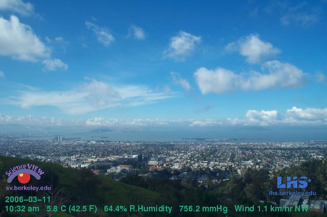
San Francisco area (I know I get California symptoms magnified but I am still going to catagorize this as - VERY STRONG.)
Webcam
----------------------------------------
(Still nothing found for this area - I have stopped getting symptoms for the area as of the 19th of March.)
Northern Chile (18.12 S 69.05 W)
----------------------------------------
2006-03-13 15:12:58.5 24.26S 67.00W 153 M4.8 CHILE-ARGENTINA BORDER REGION
2006-03-15 08:05:57 5.2 19.87S 69.63W Northern Chile
Southeast Indian Ocean then possibly Crozet Island area (STRONG for Southeast Indian Ocean)
----------------------------------------
(One occurred on the 15th but I expect more quakes for this area.)
Westcentral Italy area
----------------------------------------
2006-03-14 03:15:03.0 40.81N 15.33E 10 ML2.8 SOUTHERN ITALY
2006-03-14 13:33:43.0 40.80N 15.34E 10 ML2.5 SOUTHERN ITALY
Ryukyu Islands area
----------------------------------------
(Nothing found)
Poland
----------------------------------------
2006-03-14 04:30:42 4.5 51.48 N 16.04 E Poland
2006-03-14 10:38:11.2 51.12N 15.94E ML2.2 POLAND
2006-03-14 17:06:43.5 51.20N 15.96E 10 ML2.2 POLAND
2006-03-14 22:09:19.4 51.39N 16.28E 10 ML2.2 POLAND
2006-03-15 00:27:23 3.0 51.30 N 15.95 E Poland
2006-03-15 02:47:37.0 50.87N 16.15E 18 ML2.2 POLAND
South Africa (Second day of symptom but that is already posted for the 13th of March - Continued extremely strong.)
----------------------------------------
2006-03-14 07:25:31 5.0 21.50 S 33.40 E Mozambique
2006-03-14 07:25:31 4.9 21.48 S 33.42 E Mozambique
2006-03-15 11:52:53.1 21.12S 33.64E 10 mb5.3 MOZAMBIQUE
2006-03-15 14:19:50.7 21.09S 33.56E 30 f mb5.6 MOZAMBIQUE
2006-03-15 18:09:03 4.5 20.85S 32.83E Zimbabwe
Original site for article
AFRICA'S NEW OCEAN
A Continent Splits Apart
By Axel Bojanowski
Normally new rivers, seas and mountains are born in slow motion. The Afar Triangle near the Horn of
Africa is another story. A new ocean is forming there with staggering speed -- at least by geological
standards. Africa will eventually lose its horn.
Geologist Dereje Ayalew and his colleagues from Addis Ababa University were amazed -- and frightened.
They had only just stepped out of their helicopter onto the desert plains of central Ethiopia when the
ground began to shake under their feet. The pilot shouted for the scientists to get back to the
helicopter. And then it happened: the Earth split open. Crevices began racing toward the researchers
like a zipper opening up. After a few seconds, the ground stopped moving, and after they had
recovered from their shock, Ayalew and his colleagues realized they had just witnessed history. For the
first time ever, human beings were able to witness the first stages in the birth of an ocean. Normally
changes to our geological environment take place almost imperceptibly. A life time is too short to see
rivers changing course, mountains rising skywards or valleys opening up. In north-eastern Africa's Afar
Triangle, though, recent months have seen hundreds of crevices splitting the desert floor and the
ground has slumped by as much as 100 meters (328 feet). At the same time, scientists have observed
magma rising from deep below as it begins to form what will eventually become a basalt ocean floor.
Geologically speaking, it won't be long until the Red Sea floods the region. The ocean that will then be
born will split Africa apart.
The Afar Triangle, which cuts across Ethiopia, Eritrea and Djibouti, is the largest construction site on the
planet. Three tectonic plates meet there with the African and Arabian plates drifting apart along two
separate fault lines by one centimeter a year. A team of scientists working with Christophe Vigny of the
Paris Laboratory of Geology reported on the phenomenon in a 2006 issue of the Journal of Geophysical
Research. While the two plates move apart, the ground sinks to make room for the Red Sea and the
Gulf of Aden.
Bubbling magma and the smell of sulphur
A third crevice cuts south, splitting not far from Lake Victoria. One branch of the rift runs to the east,
the other to the west of the lake. The two branches of this third crevice are moving apart by about
one millimeter a year. Karte Afrika Afar-Senke english version Zoom SPIEGEL ONLINE Karte Afrika
Afar-Senke english version
The dramatic event that Ayalew and his colleagues witnessed in the Afar Desert on Sept. 26, 2005 was
the first visual proof of this process -- and it was followed by a week-long series of earthquakes. During
the months that followed, hundreds of further crevices opened up in the ground, spreading across an
area of 345 square miles. "The earth has not stopped moving since," geophysicist Tim Wright of the
University of Oxford says. The ground is still splitting open and sinking, he says; small earthquakes are
constantly shaking the region.
Scientists have made repeated trips to the area since the drama of last September. Locals have
reported a number of new cracks opening in the ground, says geologist Cynthia Ebinger from the
University of London, and during each visit, new crevices are discovered. Fumes as hot as 400 degrees
Celsius (752 degrees Fahrenheit) shoot up from some of them; the sound of bubbling magma and the
smell of sulphur rise from others. The larger crevices are dozens of meters deep and several hundred
meters long. Traces of recent volcanic eruptions are also visible.
In a number of places, cracks have opened up beneath the thin layer of volcanic ash that covers the
region. As there is no ash in the fissures, it's clear that they opened up after the volcanic eruptions,
most of which took place at the end of September or in October, 2005. A number of locals who fled
the eruptions have reported that a black cloud of ash -- spewed out of the Dabbahu volcano --
darkened the sky for three days.
A new ocean floor on the Earth's surface
Basalt magma has risen into some of the crevices. For the moment, Ayalew explains, the lava seems
not to be rising further. A number of recent eruptions, though, have left layers of new basalt lava on
the Earth's surface. And it's the exact same kind of lava that spews out of volcanic ridges deep under
the ocean -- a process which slowly pushes older lava sediments away on either side. The process has
only just begun in the Afar Triangle -- and scientists for the first time can witness the birth of a new
ocean floor. The source of the African magma looks to be a gigantic stream of molten rock rising from
beneath the Earth's crust and slicing through the African continental plate like a blow torch. It's a
process that began thirty million years ago when lava broke through the continent for the first time,
separating the Arabian Peninsula from Africa and creating the Red Sea.
Now, it's the Afar Triangle's turn and it's sinking rapidly. Large areas are already more than 100 meters
(328 feet) below sea level. For now, the highlands surrounding the Denakil Depression prevent the Red
Sea from flooding these areas, but erosion and tectonic plate movement are continually reducing the
height of this natural barrier. The Denakil Depression, which lies to the east of Afar, is already prey to
regular floods -- each flood leaving behind a crust of salt.
Africa to lose its horn
The chain of volcanoes that runs along the roughly 6,000 kilometer (3,730 mile) long East African Rift
System offers further testimony to the breaking apart of the continent. In some areas around the outer
edges of the Rift System, the Earth's crust has already cracked open, making room for the magma
below. From the Red Sea to Mozambique in the south, dozens of volcanoes have formed, the best
known being Mt. Kilimanjaro and Mt. Nyiragongo.
These fiery mountains too will one day sink into the sea. Geophysicists have calculated that in 10
million years the East African Rift System will be as large as the Red Sea. When that happens, Africa
will lose its horn.
Possibly Mammoth Lakes area (New symptom.)
----------------------------------------
MAP 1.7 2006/03/14 06:06:55 37.461 -118.794 8.4 15 km ( 9 mi) SW of Toms Place, CA
MAP 1.7 2006/03/14 18:17:26 37.647 -118.928 1.7 5 km ( 3 mi) ENE of Mammoth Lakes, CA
Reykjanes Ridge area
----------------------------------------
2006-03-13 05:36:19 4.8 53.48 N 32.31 W Reykjanes Ridge
Kazakhstan to Kyrgyzstan then Hindu Kush area
----------------------------------------
2006-03-15 07:15:45.0 51.80N 79.85E ML3.2 EASTERN KAZAKHSTAN
Anza, California (33.569 -116.652)
----------------------------------------
MAP 1.3 2006/03/13 00:21:58 33.471 -116.620 14.1 11 km ( 7 mi) SSE of Anza, CA
MAP 1.6 2006/03/14 04:07:02 34.301 -116.828 8.2 5 km ( 3 mi) NNE of Big Bear City, CA
MAP 1.2 2006/03/14 13:32:24 33.928 -116.809 7.8 4 km ( 3 mi) WNW of Cabazon, CA
MAP 1.3 2006/03/14 17:03:27 34.621 -116.575 9.3 39 km ( 24 mi) ENE of Lucerne Valley, CA
MAP 2.0 2006/03/14 18:16:25 33.038 -116.419 5.5 16 km ( 10 mi) ESE of Julian, CA
MAP 1.2 2006/03/14 19:28:05 34.059 -116.308 9.1 8 km ( 5 mi) S of Joshua Tree, CA
Mt. St. Helen's
----------------------------------------
MAP 1.2 2006/03/14 09:24:34 46.196 -122.185 0.0 1 km ( 0 mi) SW of Mount St. Helens Volcano, WA
MAP 2.1 2006/03/14 12:08:22 46.200 -122.190 0.0 1 km ( 0 mi) W of Mount St. Helens Volcano, WA
MAP 1.2 2006/03/14 17:51:58 46.195 -122.191 0.0 1 km ( 1 mi) WSW of Mount St. Helens Volcano, WA
Lake Tahoe area
----------------------------------------
(MAP 1.3 2006/03/14 08:47:24 40.091 -119.614 11.6 13 km ( 8 mi) SE of Zenobia, NV is in
the area.)
Peace to all.

posted by Unknown @ 2:00 PM
0 comments
![]()
![]()
