*For Tuesday, 12 December 2006.
LEGEND for OVERVIEW: Size = My surety of area for quake.
Red Circle = Probable quake to STRONG quake.
Triangle = Very Strong/Stronger quake (Usually takes extra days).
Blue Circle, etc. = Uncertainty of symptom area for probable quake.
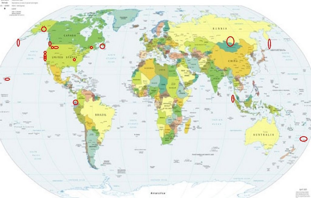
Places to watch.
Good luck to all.
For Tuesday, 12 December 2006.
--------------------------------------
Mongolia/Lake Baikal area
--------------------------------------
2006-12-13 17:44:10.8 52.90N 107.36E 20 Ms4.0 LAKE BAYKAL REGION, RUSSIA
San Francisco Bay area and south of
(37.374°N, 122.185°W) (Third day for
symptom - STRONG)
--------------------------------------
2.1Q 2006/12/12 20:24:44 37.324 -122.105 0.1 0 km ( 0 mi) SSW of Quarry near Cupertino, CA(Probable quarry explosion)
The Geysers
--------------------------------------
1.3 2006/12/12 07:57:56 38.820 -122.828 1.0 3 km ( 2 mi) NW of The Geysers, CA
1.2 2006/12/12 13:08:41 38.819 -122.795 2.0 3 km ( 2 mi) NNE of The Geysers, CA
1.7 2006/12/12 19:23:37 38.804 -122.767 0.0 3 km ( 2 mi) E of The Geysers, CA
Saanich, Canada area (48.570 -123.530)
--------------------------------------
2006/12/10 15:04:43 48.45N 123.47W 15.2 1.6ML 7 km NW of Victoria,BC
2006/12/10 21:13:05 49.74N 123.15W 0.0 1.0ML 4 km NE of Squamish,BC
2006/12/11 11:00:45 49.51N 119.47W 0.0 3.3ML 8 km NE of Penticton,BC. Felt
Montana (Fifth day symptom but keeping
it at - STRONG - this symptom is becoming
a daily thing like the symptom for Central Italy
and nothing much is showing on the lists.
Don’t know why these symptoms continue.)
--------------------------------------
(Nothing found)
Greenwater, WA area (46.876 -121.645)
(Second day symptom - Strong)
--------------------------------------
1.2 2006/12/12 03:12:15 46.853 -121.593 7.1 32 km ( 20 mi) S of Greenwater, WA
Maine (44.33N 68.14W) (Second day area
but different symptom - Strong)
--------------------------------------
Region: MAINE
Geographic coordinates: 44.366N, 68.160W
Magnitude: 2.3 M
Depth: 5 km
Universal Time (UTC): 18 Dec 2006 19:53:23
Time near the Epicenter: 18 Dec 2006 14:53:23
Local time in your area: 18 Dec 2006 14:53:23
(6 extra days and not that big.)
Kermadec Islands
--------------------------------------
2006-12-12 16:41:51 5.3mb 29.83S 177.90W 35 Kermadec Islands, New Zealand
Hawaii
--------------------------------------
1.9 2006/12/12 16:17:43 19.190 -155.632 0.0 15 km ( 9 mi) NNW of Naalehu, HI
Aleutian Trench in North Pacific
--------------------------------------
2.9 2006/12/11 07:09:04 50.900 -178.683 1.0 ANDREANOF ISLANDS, ALEUTIAN IS., ALASKA
3.5 2006/12/11 12:44:34 52.060 -175.505 93.9 ANDREANOF ISLANDS, ALEUTIAN IS., ALASKA
3.7 2006/12/11 12:44:31 51.723 -175.506 100.0ANDREANOF ISLANDS, ALEUTIAN IS., ALASKA
4.4 2006/12/12 04:41:18 51.333 -179.001 35.0 ANDREANOF ISLANDS, ALEUTIAN IS., ALASKA
Northern Sumatra
--------------------------------------
(Came in on 13th and posted there.)
Stephenville, NL area (48.74N 59.29W)
(Strong)
--------------------------------------
(Nothing found)
San Simeon/Lake Nacimiento area
--------------------------------------
1.6 2006/12/11 12:55:22 35.694 -121.130 8.1 8 km ( 5 mi) NE of San Simeon, CA
Southern Alaska
--------------------------------------
3.2 2006/12/12 04:23:47 61.793 -151.696 100.0 SOUTHERN ALASKA
2.7 2006/12/12 13:33:55 59.798 -153.344 180.0 SOUTHERN ALASKA
Kamchatka/Kurils area
--------------------------------------
2006-12-11 13:33:29.6 46.75N 152.69E 68 mb4.8 KURIL ISLANDS
2006-12-11 20:33:34.5 48.02N 155.93E 33 mb4.4 KURIL ISLANDS
2006-12-12 00:39:13.3 48.23N 153.50E 33 mb4.5 KURIL ISLANDS
2006-12-12 06:47:53.2 46.11N 151.99E 40 mb5.3 KURIL ISLANDS
2006-12-12 22:32:08 5.1mb 46.35N 153.24E 20 Kuril Islands
2006-12-13 11:40:56 5.1mb 46.26N 154.44E 10 East of Kuril Islands
2006-12-13 02:11:15 5.2mb 46.32N 153.05E 53 Kuril Islands
2006-12-13 01:57:51 5.2mb 46.22N 152.79E 63 Kuril Islands
2006-12-14 14:00:01 4.9mb 46.95N 152.74E 189 Kuril Islands
2006-12-14 10:46:36 5.1mb 47.57N 153.09E 117 Kuril Islands
2006-12-14 07:43:52 5.1mb 46.98N 146.49E 374 Northwest of Kuril Islands
2006-12-14 02:54:04 4.6mb 46.54N 152.69E 20 Kuril Islands
(2 extra days)
Colombia/Ecuador border
--------------------------------------
(Nothing found)
The New Madrid Fault/Ridgely, TN
(36.270N 89.500W) (STRONG)
--------------------------------------
Region: PENNSYLVANIA
Geographic coordinates: 40.292N, 76.037W
Magnitude: 2.5 Mcd
Depth: 6 km
Universal Time (UTC): 13 Dec 2006 19:07:52
Region: PENNSYLVANIA
Geographic coordinates: 40.191N, 75.928W
Magnitude: 2.8 M
Depth: 5 km
Universal Time (UTC): 13 Dec 2006 19:07:51
(Way off on coordinates - I will watch this symptom more carefully for repeat.)
Peace to all.

posted by Unknown @ 1:20 PM
0 comments
![]()
![]()
