*For Friday, 13 October 2006.
LEGEND for OVERVIEW: Size = My surety of area for quake.
Red Circle = Probable quake to STRONG quake.
Triangle = Very Strong/Stronger quake (Usually takes extra days).
Blue Circle, etc. = Uncertainty of symptom area for probable quake.
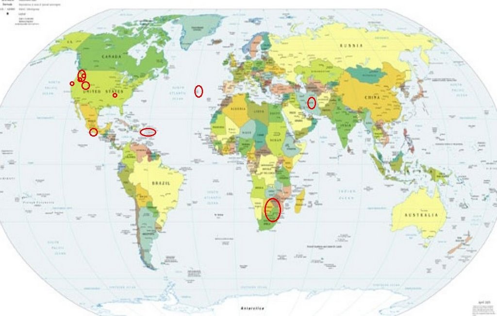
Places to watch.
Good luck to all.
For Friday, 13 October 2006.
---------------------------------------
Southern Mexico
---------------------------------------
2006-10-13 21:31:00.1 14.37N 92.51W 53 M4.6 NEAR COAST OF CHIAPAS, MEXICO
Puerto Rico/Virgin Islands
(2 different symptoms - STRONG)
---------------------------------------
2.9 2006/10/13 05:36:33 18.579N -64.940W 6.9 25 km (16 mi) N of Charlotte Amalie, Saint Thomas, US Virgin Islands
Mt. Hood area (Strong)
then Mt. Rainier area (Strong)
and others areas of Washington State
---------------------------------------
1.4 2006/10/12 00:03:52 47.882 -122.617 0.0 7 km ( 4 mi) SE of Port Ludlow, WA
1.9 2006/10/12 04:15:50 47.863 -124.045 0.0 27 km ( 17 mi) ESE of Forks, WA
2.3 2006/10/12 08:11:01 46.195 -122.195 0.0 1 km ( 1 mi) WSW of Mount St. Helens Volcano, WA
2.3 2006/10/12 08:10:59 46.264 -122.225 7.9 8 km ( 5 mi) NNW of Mount St. Helens Volcano, WA
1.7 2006/10/12 13:01:09 46.194 -122.197 0.0 1 km ( 1 mi) WSW of Mount St. Helens Volcano, WA
2.4 2006/10/12 17:24:16 46.195 -122.194 0.3 1 km ( 1 mi) WSW of Mount St. Helens Volcano, WA
2.0 2006/10/12 20:31:04 48.156 -117.841 3.6 13 km ( 8 mi) NNW of Springdale, WA
1.1 2006/10/12 23:31:33 48.435 -122.191 0.0 4 km ( 3 mi) SE of Clear Lake, WA
1.8 2006/10/13 00:07:23 47.860 -124.042 0.0 27 km ( 17 mi) ESE of Forks, WA
2.0 2006/10/13 00:15:59 46.196 -122.195 0.3 1 km ( 1 mi) WSW of Mount St. Helens Volcano, WA
1.8 2006/10/13 05:25:12 48.686 -120.020 0.8 24 km ( 15 mi) NW of Conconully, WA
2.3 2006/10/13 07:56:06 46.196 -122.192 0.0 1 km ( 1 mi) WSW of Mount St. Helens Volcano, WA
1.2 2006/10/13 13:22:17 46.197 -122.197 0.8 1 km ( 1 mi) WSW of Mount St. Helens Volcano, WA
2.7 2006/10/13 14:39:48 46.197 -122.188 0.0 1 km ( 0 mi) WSW of Mount St. Helens Volcano, WA
2.2 2006/10/13 14:51:14 46.195 -122.193 0.2 1 km ( 1 mi) WSW of Mount St. Helens Volcano, WA
1.2 2006/10/13 15:14:11 48.176 -121.653 15.9 9 km ( 6 mi) SSW of Darrington, WA
1.4 2006/10/13 18:24:14 46.025 -122.374 1.5 15 km ( 9 mi) NNE of Amboy, WA
2.2 2006/10/13 18:59:53 44.097 -121.339 0.0 5 km ( 3 mi) NNW of Bend, OR
2.1 2006/10/13 22:00:08 46.195 -122.195 0.0 1 km ( 1 mi) WSW of Mount St. Helens Volcano, WA
Utah (Indication of depth - Strong)
---------------------------------------
1.5 2006/10/13 04:50:13 39.414 -111.225 2.4 24 km ( 15 mi) ESE of Spring City, UT
1.4 2006/10/13 17:39:28 39.727 -110.939 5.2 8 km ( 5 mi) WNW of Helper, UT
1.6 2006/10/13 18:04:37 39.412 -111.223 3.2 24 km ( 15 mi) WNW of Huntington, UT
Northcentral Iran
---------------------------------------
2006-10-13 10:19:57.1 27.91N 54.26E 20f ML4.2 SOUTHERN IRAN
REPUBLIC OF SOUTH AFRICA (23.4S 30.6E)
---------------------------------------
(Nothing found)
AZORES ISLANDS, PORTUGAL (38.57N 28.47W)
(STRONG)
---------------------------------------
2006-10-12 16:47:07.0 37.77N 25.47W 4 ML2.6 AZORES ISLANDS, PORTUGAL
The New Madrid Fault/WNW of Tiptonville, TN
(36.400 -89.530)
---------------------------------------
1.2 2006/10/12 15:50:19 35.560 -84.620 13.9 8 km ( 5 mi) NW of Niota, TN
1.8 2006/10/13 01:13:22 36.570 -89.620 7.4 2 km ( 1 mi) W of Howardville, MO
1.7 2006/10/13 01:05:45 36.570 -89.620 7.2 2 km ( 1 mi) W of Howardville, MO
1.4 2006/10/13 13:03:13 36.570 -89.620 8.1 2 km ( 1 mi) W of Howardville, MO
1.6 2006/10/13 13:02:11 36.570 -89.620 7.1 2 km ( 1 mi) W of Howardville, MO
The Geysers
---------------------------------------
1.6 2006/10/13 00:09:53 38.824 -122.796 1.7 3 km ( 2 mi) NNE of The Geysers, CA
1.0 2006/10/13 00:16:49 38.828 -122.875 1.3 7 km ( 4 mi) WNW of The Geysers, CA
1.4 2006/10/13 09:20:50 38.817 -122.800 2.3 2 km ( 1 mi) NNE of The Geysers, CA
1.1 2006/10/13 16:07:35 38.811 -122.817 2.4 2 km ( 1 mi) NNW of The Geysers, CA
1.5 2006/10/14 23:00:17 38.816 -122.794 2.3 2 km ( 1 mi) NNE of The Geysers, CA
2.3 2006/10/14 21:35:38 38.833 -122.798 1.4 4 km ( 2 mi) N of The Geysers, CA
1.5 2006/10/14 20:23:48 38.816 -122.793 2.1 2 km ( 1 mi) NNE of The Geysers, CA
1.2 2006/10/14 20:06:42 38.818 -122.787 2.6 3 km ( 2 mi) NE of The Geysers, CA
2.8 2006/10/14 20:03:15 38.824 -122.783 0.1 4 km ( 2 mi) NE of The Geysers, CA
1.2 2006/10/14 18:31:44 38.817 -122.810 2.8 2 km ( 1 mi) N of The Geysers, CA
2.0 2006/10/14 18:05:23 38.819 -122.786 2.0 3 km ( 2 mi) NE of The Geysers, CA
1.2 2006/10/14 18:03:58 38.800 -122.772 2.1 3 km ( 2 mi) E of The Geysers, CA
3.1 2006/10/14 18:01:54 38.816 -122.790 4.5 2 km ( 1 mi) NE of The Geysers, CA
2.0 2006/10/14 13:02:19 38.794 -122.780 0.0 2 km ( 1 mi) E of The Geysers, CA
1.4 2006/10/14 12:14:29 38.796 -122.760 1.5 4 km ( 3 mi) E of The Geysers, CA
1.2 2006/10/14 12:07:04 38.821 -122.796 2.7 3 km ( 2 mi) NNE of The Geysers, CA
1.6 2006/10/14 11:32:17 38.793 -122.770 2.1 3 km ( 2 mi) E of The Geysers, CA
2.1 2006/10/14 06:25:14 38.821 -122.787 2.1 3 km ( 2 mi) NE of The Geysers, CA
1.0 2006/10/14 03:21:55 38.814 -122.825 2.3 2 km ( 1 mi) NW of The Geysers, CA
1.8 2006/10/14 02:55:08 38.823 -122.783 0.6 3 km ( 2 mi) NE of The Geysers, CA
Peace to all.

posted by Unknown @ 1:26 PM
0 comments
![]()
![]()
