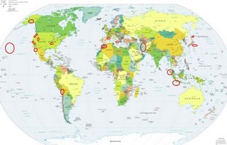
*For Tuesday, 8 August 2006.
LEGEND for OVERVIEW: Size = My surety of area for quake.
Red Circle = Probable quake to STRONG quake.
Triangle = Very Strong/Stronger quake (Usually takes extra days).
Blue Circle, etc. = Uncertainty of symptom area for probable quake.

Places to watch.
Good luck to all.
For Tuesday, 8 August 2006.
----------------------------------------
PYRENEES (42.34N 1.41E) (2 different
symptoms - Strong)
----------------------------------------
2006-08-07 23:22:49.7 37.05N 8.25W 102 mb3.0 PORTUGAL
2006-08-08 05:18:35.3 44.04N 4.86E 10 ML2.8 FRANCE
2006-08-08 13:12:24.0 45.00N 6.64E 2 ML3.0 FRANCE
2006-08-08 17:51:35.7 48.32N 6.67E 5 ML2.6 FRANCE
Eastern Honshu area (36.04N 139.68E)
(STRONG)
----------------------------------------
2006/08/08,21:21 32.6N 141.9E 10km Mj 3.9 E_OFF_HACHIJOJIMA_ISLAND 64.05
2006/08/08,03:51 32.5N 141.9E 70km Mj 3.6 E_OFF_HACHIJOJIMA_ISLAND 73.92
Sicily, Italy/Ionian Sea (medium)
----------------------------------------
2006-08-08 19:48:27.0 43.49N 12.43E 1 ML2.5 CENTRAL ITALY
(Possibly all the Albania quakes were also included in this symptom - very close in global terms.)
Morocco area (Much fewer symptoms-
medium)
----------------------------------------
2006-08-08 04:28:38.6 36.62N 9.65W 111 ML2.8 WEST OF GIBRALTAR
San Simeon area
----------------------------------------
(Nothing found)
Hokkaido area
----------------------------------------
2006/08/07,15:47 45.7N 151.9E 30 km Mj 4.1 KURILE_ISLANDS_REGION 55.16
2006/08/07,09:02 46.4N 153.2E 30 km Mj 4.4 KURILE_ISLANDS_REGION 83.14
(More north than expected...also posted one of these on the 9th for Kurils.)
The New Madrid Fault
----------------------------------------
2.8 2006/08/09 04:41:50 34.589N 97.368W 5.0 20 km (12 mi) WSW of Wynnewood, OK?
(Very doubtful that this has anything to do with the New Madrid Fault - but it was interesting.)
Mt. St. Helen’s
----------------------------------------
1.6 2006/08/08 07:23:38 46.197 -122.193 0.0 1 km ( 1 mi) WSW of Mount St. Helens Volcano, WA
2.4 2006/08/08 10:00:44 46.181 -122.196 0.0 2 km ( 2 mi) SSW of Mount St. Helens Volcano, WA
1.6 2006/08/08 11:48:12 46.196 -122.189 0.0 1 km ( 1 mi) WSW of Mount St. Helens Volcano, WA
North Pacific/Hawaii area
----------------------------------------
2.5 2006/08/08 14:39:53 19.332 -155.401 29.4 16 km ( 10 mi) NNE of Pahala, HI
Northcentral Iran/other areas of Iran
(STRONG)
----------------------------------------
2006-08-07 05:54:09.9 30.60N 50.94E 4 M3.6 NORTHERN AND CENTRAL IRAN
2006-08-07 11:29:55.0 40.25N 50.71E ML3.6 CASPIAN SEA
SOUTH OF JAWA, INDONESIA (9.2S 107.6E)
(Medium)
----------------------------------------
2006-08-07 20:07:32 5.1 9.53S 108.07E 20 km South of Java, Indonesia
2006-08-10 23:56:43.2 9.02S 107.23E 60 mb4.6 SOUTH OF JAWA, INDONESIA
(2 extra days)
BAJA CALIFORNIA, MEXICO (31.922 -116.180)
----------------------------------------
1.5 2006/08/08 07:52:21 32.648 -116.424 2.0 21 km ( 13 mi) ENE of Tecate, Mexico
2.6 2006/08/08 17:34:45 31.643 -116.551 6.0 BAJA CALIFORNIA, MEXICO
2.8 2006/08/08 21:16:04 32.194 -115.849 6.4 BAJA CALIFORNIA, MEXICO
Coso Junction area
----------------------------------------
1.0 2006/08/08 06:41:37 36.129 -117.897 4.9 10 km ( 6 mi) NNE of Coso Junction, CA
2.1 2006/08/08 15:32:54 36.027 -117.769 2.0 16 km ( 10 mi) E of Coso Junction, CA
2.1 2006/08/08 21:25:18 36.130 -117.901 3.6 10 km ( 6 mi) NNE of Coso Junction, CA
1.2 2006/08/08 23:51:28 36.029 -117.767 2.6 16 km ( 10 mi) E of Coso Junction, CA
Southern Alaska (61.281 -152.289)
(Indication of depth and volcanics-
Strong)
----------------------------------------
2.5 2006/08/08 14:49:30 60.070 -152.904 120.0 SOUTHERN ALASKA
2.9 2006/08/08 19:02:13 59.946 -153.234 120.0 SOUTHERN ALASKA
2.5 2006/08/08 20:23:39 61.819 -147.802 200.0 SOUTHERN ALASKA
Northern Sumatra
----------------------------------------
(Nothing found)
CHILE-BOLIVIA BORDER REGION
(19.82S 68.89W)
----------------------------------------
4.3 2006/08/11 06:26:29 -22.067 -67.504 146.3 POTOSI, BOLIVIA
(3 extra days)
Utah/Nevada
----------------------------------------
1.0 2006/08/08 00:42:56 39.610 -110.387 1.4 7 km ( 4 mi) N of Sunnyside, UT
1.6 2006/08/08 17:12:00 39.415 -111.229 3.2 24 km ( 15 mi) ESE of Spring City, UT
1.0 2006/08/08 21:22:32 38.956 -112.962 7.0 48 km ( 30 mi) SSW of Hinckley, UT
1.6 2006/08/08 23:28:15 39.614 -110.390 1.3 7 km ( 4 mi) N of Sunnyside, UT
1.4 2006/08/08 23:31:38 40.246 -111.891 1.4 9 km ( 6 mi) S of Saratoga Springs, UT
Drain, Oregon area (43.636N 123.301W)
----------------------------------------
1.0 2006/08/07 09:37:23 45.344N 121.735W 3.6 19 km (12 mi) E of Mount Hood Village, OR
1.9 2006/08/10 23:22:13 44.972N 123.239W 27.7 5 km ( 3 mi) N of Rickreall, OR
(This is a difficult sympom to figure because it is on the left back of my head - probably Rickreall,
making it 2 days extra to come in.)
Peace to all.

