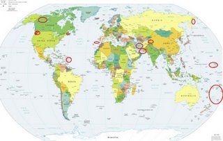
*For Thursday, 19 October 2006.
LEGEND for OVERVIEW: Size = My surety of area for quake.
Red Circle = Probable quake to STRONG quake.
Triangle = Very Strong/Stronger quake (Usually takes extra days).
Blue Circle, etc. = Uncertainty of symptom area for probable quake.

Places to watch.
Good luck to all.
For Thursday, 19 October 2006.
--------------------------------------
Fiji to Kermadec Islands and Tonga
(Second day symptom - non
specific - STRONG)
--------------------------------------
2006-10-20 14:13:00.1 23.02S 176.79W 33 mb5.9 SOUTH OF FIJI ISLANDS
21Oct2006 05:24:09.2 25.2S 179.1W400 mb=5.0 M GSR SOUTH OF FIJI ISLANDS
(2 extra days)
Washington State/Oregon State /Mt. Hood area
Dollar Corner, WA area (45.785N 122.633W)
Lake Cavanaugh, WA area (48.308 -122.077)
--------------------------------------
1.9 2006/10/19 19:35:25 46.196N 122.195W 0.0 1 km ( 1 mi) WSW of Mount St. Helens Volcano, WA
2.1 2006/10/19 12:02:55 46.196N 122.195W 0.7 1 km ( 1 mi) WSW of Mount St. Helens Volcano, WA
1.8 2006/10/19 03:29:57 46.195N 122.189W 0.0 1 km ( 1 mi) SW of Mount St. Helens Volcano, WA
2.2 2006/10/19 01:14:28 46.194N 122.187W 0.0 1 km ( 1 mi) SW of Mount St. Helens Volcano, WA
2.4 2006/10/20 23:01:13 46.196N 122.188W 0.2 1 km ( 0 mi) SW of Mount St. Helens Volcano, WA
2.3 2006/10/20 16:25:53 44.374N 121.367W 5.7 15 km ( 9 mi) W of Terrebonne, OR
1.7 2006/10/20 16:03:30 46.850N 121.597W 6.0 32 km (20 mi) S of Greenwater, WA
2.1 2006/10/20 15:01:09 46.195N 122.188W 0.0 1 km ( 1 mi) SW of Mount St. Helens Volcano, WA
1.2 2006/10/20 11:54:31 46.863N 121.606W 5.8 31 km (19 mi) S of Greenwater, WA
2.2 2006/10/20 05:05:39 46.195N 122.196W 0.7 1 km ( 1 mi) WSW of Mount St. Helens Volcano, WA
1.3 2006/10/20 03:45:31 46.851N 121.590W 6.5 32 km (20 mi) S of Greenwater, WA
Mariana Islands
--------------------------------------
2006-10-20 08:41:51.5 21.84N 142.88E 33 mb4.9 MARIANA ISLANDS REGION
Eastern Siberia
--------------------------------------
2006-10-19 07:15:37.0 64.21N 148.79E 40f mb5.1 SOUTHEASTERN SAKHA, RUSSIA
2006-10-20 11:14:31.3 61.04N 167.13E 2 mb5.1 KORYAKIA, RUSSIA
2006-10-21 05:33:14 5.1 53.87N 130.35E 20 Southeastern Siberia, Russia
(2 extra days)
Strait of Gibraltar area
--------------------------------------
2006-10-19 02:20:29.5 35.08N 3.87W mb3.1 STRAIT OF GIBRALTAR
Hindu Kush area (Strong)
--------------------------------------
2006-10-19 01:32:56.0 40.71N 83.09E ML3.5 SOUTHERN XINJIANG, CHINA
Yukon/Northwest Territories (Medium)
--------------------------------------
2006/10/19 08:40:02 62.16N 128.26W 10.0* 3.3ML 228 km NE of Watson Lk.,YT
Southern Iran (27.70N 55.52E)(Strong)
and Northcentral Iran (Strong)
--------------------------------------
(Nothing found)
CHARLEVOIX SEISMIC ZONE, QUE.
(47.74N 69.72W)
--------------------------------------
2006/10/18 22:50:39 47.41N 70.28W 11.2 1.4MN CHARLEVOIX SEISMIC ZONE,QC.
2006/10/19 17:02:37 46.70N 71.57W 18.0* 1.7MN 9 km SW from Saint-Augustin,QC
Virgin Islands
--------------------------------------
4.3 2006/10/19 12:05:18 17.691N -62.567W 126.9 38 km (24 mi) SE of Saint-Barthélemy, Saint Barthélemy, Guadeloupe
3.7 2006/10/19 07:15:48 19.196N -64.471W 54.8 54 km (34 mi) NNW of Settlement, Anegada, British Virgin Islands
3.3 2006/10/19 01:33:16 18.450N -65.000W 155.2 13 km ( 8 mi) NNW of Charlotte Amalie, Saint Thomas, US Virgin Islands
Peace to all.

