*For Monday, 25 December 2006.
LEGEND for OVERVIEW: Size = My surety of area for quake.
Red Circle = Probable quake to STRONG quake.
Triangle = Very Strong/Stronger quake (Usually takes extra days).
Blue Circle, etc. = Uncertainty of symptom area for probable quake.
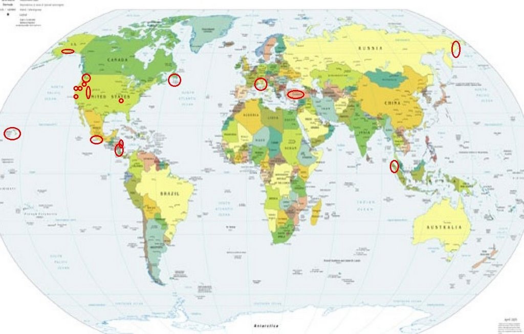
Places to watch.
Good luck to all.
For Monday, 25 December 2006.
--------------------------------------
The New Madrid Fault (Non-specific but
strong)
--------------------------------------
1.4 2006/12/26 11:06:12 36.540N 89.570W 5.5 6 km ( 4 mi) SW of New Madrid, MO
1.1 2006/12/26 05:25:04 35.770N 84.320W 14.7 4 km ( 3 mi) NNE of Loudon, TN
Washington State/Greenwater maybe
--------------------------------------
1.2 2006/12/25 05:12:18 47.120 -121.828 19.8 16 km ( 10 mi) SE of Enumclaw, WA
1.8 2006/12/25 13:24:56 48.537 -122.597 17.5 4 km ( 3 mi) NNE of Anacortes, WA
Nicaragua/Costa Rica (Second day
symptom - Strong)
--------------------------------------
(Posted on 24th and 26th)
Chiapas, Mexico
--------------------------------------
2006/12/25 17:42:00 17.01 95.30 111 3.9 31km al NOROESTE de MATIAS ROMERO, OAX
Hawaii (Indication of depth and 2 different
symptoms - STRONG)
--------------------------------------
1.8 2006/12/24 10:25:48 19.503 -155.302 34.3 9 km ( 6 mi) NW of Volcano, HI
1.9 2006/12/24 14:33:21 19.368 -155.214 2.9 9 km ( 6 mi) SSE of Volcano, HI
2.5 2006/12/24 15:15:19 19.247 -155.446 7.6 6 km ( 4 mi) NE of Pahala, HI
2.6 2006/12/24 22:12:10 20.321 -156.099 26.7 29 km ( 18 mi) WNW of Hawi, HI
2.3 2006/12/24 23:42:00 19.233 -155.582 6.0 11 km ( 7 mi) WNW of Pahala, HI
2.3 2006/12/25 03:42:42 19.344 -155.107 6.6 14 km ( 9 mi) S of Fern Forest, HI
2.0 2006/12/25 13:59:03 19.969 -156.239 12.8 37 km ( 23 mi) NW of Kalaoa, HI
2.0 2006/12/25 17:39:50 19.893 -155.502 15.1 21 km ( 13 mi) S of Honokaa, HI
1.8 2006/12/25 18:56:10 19.436 -154.932 2.7 4 km ( 3 mi) SSW of Leilani Estates, HI
Switzerland to Central Italy
--------------------------------------
(Nothing found)
Honduras area (May go with Nicaragua/Costa
Rica post)
--------------------------------------
06/12/25 16:16:17 11.48N 86.88W 94.2 3.1ML Frente a Masachapa
Newfoundland area (48.68N 59.32W)
to North Atlantic
--------------------------------------
2006/12/24 07:47:35 45.57N 59.09W 18.0* 2.4MN 65 km E from Louisbourg,NS
2006/12/24 01:35:42 47.36N 65.90W 5.0* 1.3MN 36 km SW from Bathurst,NB
Alaska Peninsula
--------------------------------------
3.5 2006/12/25 19:06:01 55.547 -158.084 15.0 ALASKA PENINSULA
3.0 2006/12/25 21:58:53 54.005 -162.540 1.0 ALASKA PENINSULA
Northeastern Siberia (Second day
symptom - Strong)
--------------------------------------
(Nothing found)
Utah/Nevada
--------------------------------------
06/12/25 09:13:34 39.46N 111.22W 6.1 2.5 14.2 mi ESE of Mount Pleasant
06/12/25 22:11:42 39.46N 111.21W 6.4 1.6 14.2 mi ESE of Mount Pleasant
06/12/25 23:21:39 39.73N 110.79W 0.6 1.2 4.8 mi NE of Helper
1.2 2006/12/25 05:08:33 36.298 -116.036 0.0 10 km ( 6 mi) NNW of Pahrump, NV
3.0 2006/12/25 08:44:10 37.169 -114.738 0.0 26 km ( 16 mi) NNW of Hoya, NV
The Parkfield Fault/Pinnacles area
--------------------------------------
1.7 2006/12/25 01:02:55 36.383 -120.966 5.7 23 km ( 14 mi) SE of Pinnacles, CA
1.9 2006/12/25 18:56:54 35.889 -120.442 11.1 1 km ( 1 mi) SW of Parkfield, CA
Petrolia
--------------------------------------
(Nothing found)
Myrtletown, CA area (40.743 -123.993)
--------------------------------------
(Nothing found)
Northern Sumatra
--------------------------------------
(Nothing found)
Turkey (MEDIUM)
--------------------------------------
2006-12-25 09:27:56.9 39.32N 40.89E 4 MD3.4 EASTERN TURKEY
2006-12-25 08:03:55.9 39.15N 27.52E 8 MD2.8 WESTERN TURKEY
2006-12-25 13:22:11.0 37.07N 27.98E 6 MD2.9 WESTERN TURKEY
2006-12-25 15:14:40.2 37.16N 34.73E 10 MD2.9 CENTRAL TURKEY
2006-12-25 17:28:02.6 39.67N 42.86E 5 MD3.0 EASTERN TURKEY
2006-12-25 19:54:46.6 37.63N 30.08E 5 MD3.1 WESTERN TURKEY
2006-12-25 19:50:38.0 39.19N 28.05E 5 MD2.9 WESTERN TURKEY
Newberg, OR area (45.438N 123.298W)
(STRONG)
--------------------------------------
2.6 2006/12/24 23:39:30 44.911 -122.628 19.9 13 km ( 8 mi) N of Mehama, OR
Peace to all.

posted by Unknown @ 11:54 AM
0 comments
![]()
![]()
