*For Tuesday, 15 August 2006.
LEGEND for OVERVIEW: Size = My surety of area for quake.
Red Circle = Probable quake to STRONG quake.
Triangle = Very Strong/Stronger quake (Usually takes extra days).
Blue Circle, etc. = Uncertainty of symptom area for probable quake.
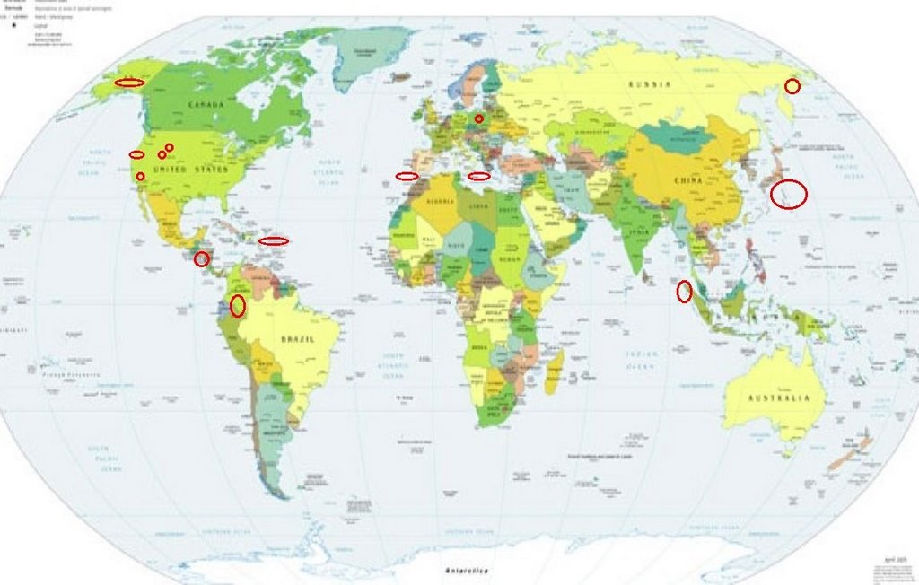
Places to watch.
Good luck to all.
For Tuesday, 15 August 2006.
----------------------------------------
Lincoln, MT area (46.824 -112.751)
(Indication of depth - Strong)
----------------------------------------
06/08/14 07:04:17 44.46N 110.58W 1.9 1.0 2.9 mi NNW of West Thumb
1.2 2006/08/14 11:45:11 48.047 -115.089 3.8 45 km ( 28 mi) ENE of Trout Creek, MT
West of Gibraltar (36.57N 9.45W)
(2 different symptoms - STRONG)
----------------------------------------
2006-08-15 20:40:12.0 36.78N 9.60W 15 ML2.1 WEST OF GIBRALTAR
2006-08-15 21:46:05.2 36.13N 4.69W 117 mb3.0 STRAIT OF GIBRALTAR
2006-08-15 22:10:49.2 35.50N 1.32W mb3.4 NORTHERN ALGERIA
Puerto Rico/Virgin Islands
----------------------------------------
4.5 2006/08/15 01:30:30 19.008 -64.728 6.9 53 km(33 mi) NW of Settlement, British Virgin Islands
3.2 2006/08/15 01:42:33 19.004 -64.603 12.0 43 km(26 mi) NW of Settlement, British Virgin Islands
3.3 2006/08/15 02:09:57 18.990 -64.612 28.8 42 km(26 mi) NW of Settlement, British Virgin Islands
2.9 2006/08/15 07:35:27 19.026 -64.611 24.5 45 km(28 mi) NW of Settlement, British Virgin Islands
3.1 2006/08/15 07:49:13 19.004 -65.292 10.8 78 km(48 mi) N of Culebra, PR
2.7 2006/08/15 07:54:37 17.834 -65.611 9.7 33 km(20 mi) SSW of Esperanza, PR
3.5 2006/08/15 15:02:39 18.991 -64.396 26.8 30 km(19 mi) NNW of Settlement, British Virgin Islands
Eastern Siberia
----------------------------------------
(Nothing found)
Utah
----------------------------------------
1.3 2006/08/15 00:25:16 39.728 -110.757 5.0 10 km ( 6 mi) ENE of Helper, UT
1.4 2006/08/15 02:07:13 39.617 -110.401 1.6 7 km ( 4 mi) N of Sunnyside, UT
1.3 2006/08/15 04:19:12 39.616 -110.394 1.4 7 km ( 4 mi) N of Sunnyside, UT
1.5 2006/08/15 12:24:52 39.731 -110.755 3.4 10 km ( 6 mi) ENE of Helper, UT
1.0 2006/08/15 20:18:23 39.103 -111.825 18.8 3 km ( 2 mi) SSW of Centerfield, UT
1.8 2006/08/15 23:25:10 39.732 -110.741 1.4 11 km ( 7 mi) ENE of Helper, UT
1.6 2006/08/16 01:14:24 39.615 -110.394 1.5 7 km ( 4 mi) N of Sunnyside, UT
1.6 2006/08/16 01:19:28 39.420 -111.224 3.6 24 km ( 15 mi) ESE of Spring City, UT
1.4 2006/08/16 01:27:45 39.614 -110.391 1.4 7 km ( 4 mi) N of Sunnyside, UT
1.5 2006/08/16 15:12:31 39.615 -110.394 1.6 7 km ( 4 mi) N of Sunnyside, UT
1.7 2006/08/16 16:23:37 39.614 -110.395 1.7 7 km ( 4 mi) N of Sunnyside, UT
1.4 2006/08/16 16:27:28 39.410 -111.237 9.6 23 km ( 14 mi) ESE of Spring City, UT
1.1 2006/08/16 17:36:53 39.722 -110.764 7.6 9 km ( 6 mi) ENE of Helper, UT
1.7 2006/08/16 17:37:05 39.733 -110.738 5.2 11 km ( 7 mi) ENE of Helper, UT
1.5 2006/08/16 18:36:50 39.614 -110.392 1.5 7 km ( 4 mi) N of Sunnyside, UT
1.7 2006/08/16 19:19:32 39.623 -110.407 1.2 8 km ( 5 mi) N of Sunnyside, UT
1.4 2006/08/16 20:24:58 39.730 -110.745 0.5 11 km ( 7 mi) ENE of Helper, UT
1.3 2006/08/16 21:01:37 39.420 -111.220 7.6 24 km ( 15 mi) WNW of Huntington, UT
1.4 2006/08/16 23:29:08 39.418 -111.220 7.0 24 km ( 15 mi) WNW of Huntington, UT
1.0 2006/08/16 23:52:37 41.940 -112.573 2.6 12 km ( 7 mi) ESE of Snowville, UT
Southern Alaska (STRONG)
----------------------------------------
2.5 2006/08/15 11:03:01 60.118 -147.089 20.0 SOUTHERN ALASKA
El Salvador area (12.57N 89.30W)
----------------------------------------
06/08/16 01:32:33 13.19N 89.09W 1.0 3.7ML Frente a El Salvador
Peru/Colombia area
----------------------------------------
4.4 2006/08/16 05:16:24 -1.784 -78.105 32.6 ECUADOR
Northern Sumatra
----------------------------------------
(Nothing found)
IZU ISLANDS, JAPAN REGION
(31.307 139.87) (STRONG)
----------------------------------------
4.7 2006/08/15 02:52:53 29.342 141.782 35.0 IZU ISLANDS, JAPAN REGION
Mammoth Lakes/Tom’s Place
(Second day symptom -
Strong)
----------------------------------------
1.5 2006/08/16 02:28:10 37.540 -118.859 9.5 15 km(9 mi) SE of Mammoth Lakes, CA
1.5 2006/08/16 04:52:06 37.541 -118.865 10.015 km(9 mi) SE of Mammoth Lakes, CA
1.7 2006/08/16 05:25:28 37.542 -118.865 9.6 15 km(9 mi) SE of Mammoth Lakes, CA
1.6 2006/08/16 15:25:44 37.508 -118.093 4.1 18 km(11 mi) NNW of Deep Springs, CA
1.7 2006/08/16 18:16:31 37.572 -118.826 3.7 13 km(8 mi) W of Toms Place, CA
Sicily, Italy/Ionian Sea
----------------------------------------
2006-08-15 00:15:51.0 40.10N 19.80E ML 3.2 ALBANIA
2006-08-15 17:37:05.0 38.43N 15.47E 133 ML 2.9 SICILY, ITALY
2006-08-15 21:17:52.2 40.14N 20.43E 2G ML 2.9 GREECE-ALBANIA BORDER REGION
2006-08-15 21:13:55.9 40.84N 20.81E 2G ML 2.4 GREECE-ALBANIA BORDER REGION
Poland (Second day symptom -
Strong)
----------------------------------------
(Nothing found)
The Geysers
----------------------------------------
1.7 2006/08/15 05:36:59 38.822 -122.783 1.4 3 km (2 mi) NE of The Geysers, CA
1.9 2006/08/15 09:56:49 38.800 -122.768 0.9 3 km (2 mi) E of The Geysers, CA
2.3 2006/08/15 11:46:03 38.818 -122.808 3.0 2 km (1 mi) N of The Geysers, CA
1.1 2006/08/15 14:41:49 38.817 -122.809 3.1 2 km (1 mi) N of The Geysers, CA
1.3 2006/08/15 23:32:03 38.809 -122.791 3.9 2 km (1 mi) NE of The Geysers, CA
1.8 2006/08/15 23:45:26 38.811 -122.825 1.9 2 km (1 mi) NW of The Geysers, CA
1.7 2006/08/16 21:01:38 38.828 -122.797 1.9 3 km (2 mi) NNE of The Geysers, CA
1.4 2006/08/16 03:29:50 38.807 -122.796 2.4 1 km (1 mi) NE of The Geysers, CA
2.1 2006/08/16 03:22:10 38.803 -122.821 2.9 1 km (1 mi) WNW of The Geysers, CA
Peace to all.

posted by Unknown @ 11:14 AM
0 comments
![]()
![]()
