*For Monday, 13 February 2006.
LEGEND for OVERVIEW:
Size = My surety of area for quake.
Red Circle = Probable quake to STRONG quake.
Triangle = Very Strong or Stronger quake (And usually takes extra days).
Blue Circle, etc. = Uncertainty of symptom area for probable quake.
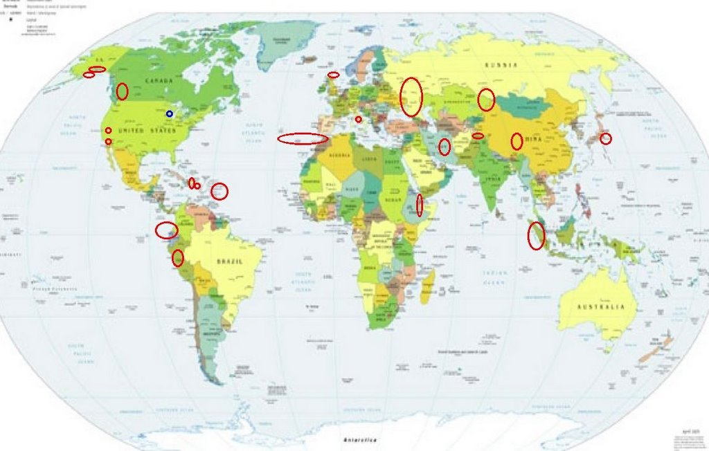
Places to watch.
Good luck to all.
For Monday, 13 February 2006.
----------------------------------------
Central Peru
----------------------------------------
(Nothing found)
Sumatra
----------------------------------------
2006-02-13 09:32:07.6 2.97N 95.53E 30 mb5.1 OFF W. CST OF NORTHERN SUMATERA
2006-02-13 12:05:44.0 2.54N 96.39E 26 M5.0 NORTHERN SUMATERA, INDONESIA
13Feb2006 12:18:09.7 2.5N 96.3E 33 mb=5.1 M*GSR NORTHERN SUMATERA, INDONES1341
Italy (Medium)
----------------------------------------
2006-02-13 05:35:00.0 38.46N 13.68E 20 ML3.3 SICILY, ITALY
2006-02-13 01:12:00.0 38.18N 13.49E 10 ML2.2 SICILY, ITALY
Strait of Gibraltar to Azores area (Strong)
----------------------------------------
2006-02-14 16:24:22.5 36.96N 3.38E mb4.2 NORTHERN ALGERIA
2006-02-14 17:43:45.5 35.17N 4.04W mb3.1 STRAIT OF GIBRALTAR
Eastern Russia/Caucasus area (STRONG)
----------------------------------------
BALTIC STATES-BELARUS-NW RUSSIA REGION
Origin time Lat Lon Azres Timres Wres Nphase Ntot Nsta Netmag
2006-043:07.47.29.0 59.55 36.16 17.85 0.04 4.50 3 3 3 2.13
BALTIC STATES-BELARUS-NW RUSSIA REGION
Origin time Lat Lon Azres Timres Wres Nphase Ntot Nsta Netmag
2006-043:19.46.57.0 56.64 32.21 1.10 0.34 0.62 2 2 1 2.57
UKRAINE - MOLDOVA - SOUTHWESTERN RUSSIA REGION
Origin time Lat Lon Azres Timres Wres Nphase Ntot Nsta Netmag
2006-043:19.57.58.0 48.41 22.97 11.15 0.00 2.79 2 3 1 3.22
BALTIC STATES-BELARUS-NW RUSSIA REGION
Origin time Lat Lon Azres Timres Wres Nphase Ntot Nsta Netmag
2006-044:11.53.08.0 58.09 28.58 5.63 1.22 2.63 4 4 2 2.19
Ecuador/Colombia area
----------------------------------------
(Nothing found)
Cabazon, California (33.864 -116.786)
----------------------------------------
MAP 1.1 2006/02/11 04:06:05 33.832 -116.800 3.8 9 km ( 6 mi) SSW of Cabazon, CA
MAP 1.5 2006/02/12 14:34:33 34.015 -116.775 20.1 11 km ( 7 mi) SSE of Mt. San Gorgonio, CA
MAP 1.4 2006/02/13 02:10:48 34.019 -116.774 18.8 10 km ( 6 mi) SSE of Mt. San Gorgonio, CA
MAP 1.9 2006/02/13 05:01:37 33.986 -116.658 19.9 10 km ( 6 mi) SW of Morongo Valley, CA
East Coast of Kazakhstan (Felt volcanic but there are no volcanos in the area. - Strong)
Geographic coordinates - 48 N, 68 E
Location - Central Asia, northwest of China
Terrain - extends from the Volga to the Altai Mountains and from the plains in western Siberia to oases and desert in Central Asia; landlocked; Russia leases approximately 6,000 sq km of territory enclosing the Baykonur Cosmodrome
Highest Point - Khan Tangiri Shyngy (Pik Khan-Tengri) 6,995 m
Natural hazards - earthquakes in the south, mudslides around Almaty
Volcanic Activity - No volcanoes
----------------------------------------
2006-02-13 10:54:40.0 47.72N 81.29E ML 3.3 EASTERN KAZAKHSTAN
2006-02-13 12:21:32.0 43.05N 70.37E ML 3.1 CENTRAL KAZAKHSTAN
Ethiopia area (11.49N 43.44E) (MEDIUM)
----------------------------------------
2006-02-11 11:09:09.3 11.72N 42.88E 26 ML3.4 ETHIOPIA
2006-02-11 10:59:52.9 11.73N 42.99E 10 ML3.6 ETHIOPIA
2006-02-11 10:46:05.8 11.67N 43.09E 6 ML 4.1 ETHIOPIA
2006-02-11 12:51:20.5 11.70N 43.30E 7 ML 3.3 ETHIOPIA
006-02-12 16:17:45.9 13.43N 44.08E 8 ML 2.8 WESTERN ARABIAN PENINSULA
Dominican Republic area (18.380N -68.145W) then Puerto Rico then further out into Atlantic (Medium for each area)
----------------------------------------
MAP 3.5 2006/02/13 09:37:37 18.384 -67.859 107.6 64 km ( 40 mi) W of Rincón, PR
MAP 3.3 2006/02/13 12:32:53 19.527 -64.314 76.4 89 km ( 55 mi) N of Settlement, British Virgin Islands
MAP 3.1 2006/02/13 19:57:34 19.172 -66.574 25.2 79 km ( 49 mi) N of Tierras Nuevas Poniente, PR
MAP 2.6 2006/02/13 20:41:52 18.326 -67.273 15.9 3 km ( 2 mi) SW of Rincón, PR
MAP 3.6 2006/02/14 09:07:07 19.154 -64.495 65.4 51 km ( 31 mi) NNW of Settlement, British Virgin Islands
MAP 2.3 2006/02/14 14:57:47 18.255 -66.366 34.9 4 km ( 3 mi) NE of Orocovis, PR
MAP 3.0 2006/02/14 18:10:31 19.095 -66.480 25.0 70 km ( 44 mi) N of Tierras Nuevas Poniente, PR
Shetland-Orkney Islands area (60.22 -0.33) (Medium)
----------------------------------------
2006-02-13 18:17:29 4.6 59.63 N 29.84 W Reykjanes Ridge
2006-02-13 18:08:55 4.8 59.63 N 30.33 W Reykjanes Ridge
2006-02-13 17:59:15 4.6 59.15 N 30.52 W Reykjanes Ridge
(Much further West than expected.)
British Columbia, Canada (Non-specific but indication of deep quake)
----------------------------------------
2006/02/13 12:43:49 51.21N 130.92W 10F 4.3 220 km WSW Bella Bella BC
Alaska Peninsula then Southern Alaska
----------------------------------------
MAP 2.7 2006/02/13 10:28:47 60.583 -147.862 20.0 SOUTHERN ALASKA
MAP 2.5 2006/02/13 16:33:57 58.307 -154.858 10.0 ALASKA PENINSULA
MAP 2.8 2006/02/13 22:03:15 61.946 -151.063 30.0 SOUTHERN ALASKA
Islamabad, Pakistan (MEDIUM)
----------------------------------------
(Nothing found)
Northcentral Iran area (31.67 N 50.01 E) (Strong)
----------------------------------------
(Nothing found)
Possibly Wisconsin/Minnesota border area (New symptom)
----------------------------------------
map 1.2 2006/02/13 07:19:07 36.540N 89.660W 7.9 13 km ( 8 mi) WSW of New Madrid, MO
map 1.5 2006/02/13 07:19:00 36.540N 89.660W 7.9 13 km ( 8 mi) WSW of New Madrid, MO
(Not as far North as I thought)
Quinghai, China area (33.76N 91.24E) (Medium)
----------------------------------------
2006-02-14 00:55:23.8 27.44N 88.33E 33 mb 5.5 SIKKIM, INDIA
Yosemite Lakes, California area (37.165°N, 119.882°W)
----------------------------------------
MAP 1.3 2006/02/12 16:27:22 37.168 -119.592 5.0 10 km ( 6 mi) SW of North Fork, CA
Honshu, Japan
----------------------------------------
2006-02-13 08:23:20.2 38.30N 139.63E 40 mb5.0 NEAR W. CST EASTERN HONSHU
2006-02-13 08:23:16.1 38.24N 139.65E 10 mb5.1 NEAR W. CST EASTERN HONSHU
2006-02-13 08:23:23.2 38.36N 139.73E 47 M4.7 NEAR W. CST EASTERN HONSHU
Peace to all.

posted by Unknown @ 1:41 PM
0 comments
![]()
![]()
