*For Sunday, 7 January 2007.
LEGEND for OVERVIEW: Size = My surety of area for quake.
Red Circle = Probable quake to STRONG quake.
Triangle = Very Strong/Stronger quake (Usually takes extra days).
Blue Circle, etc. = Uncertainty of symptom area for probable quake.
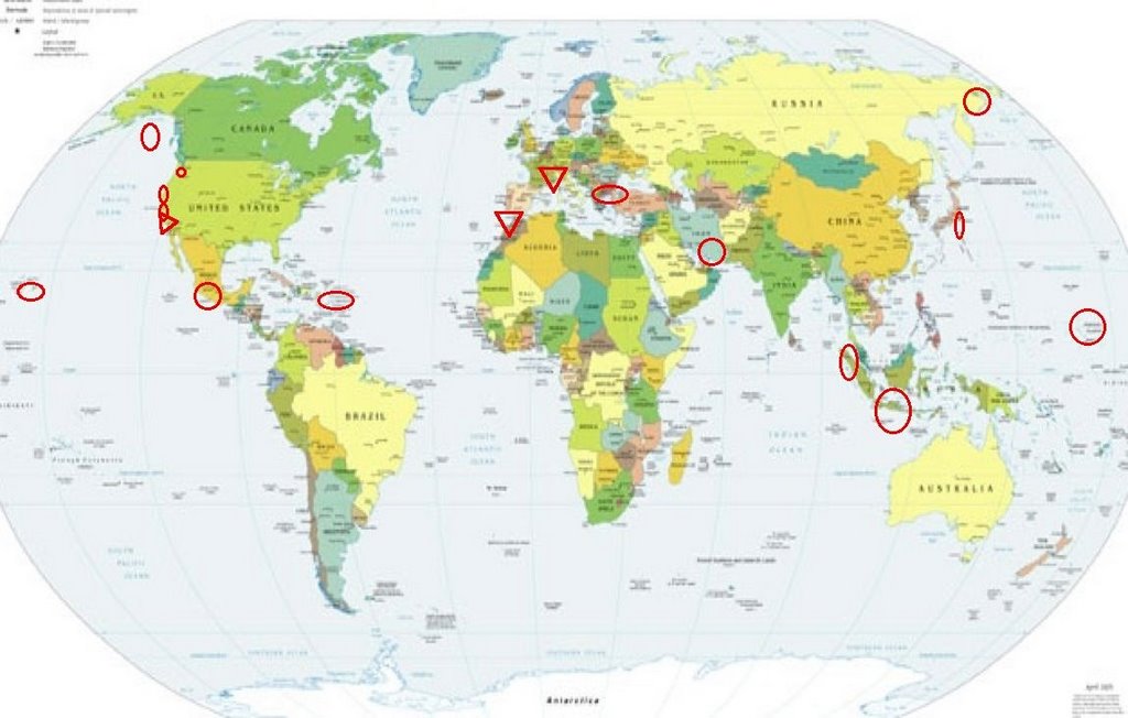
Places to watch.
Good luck to all.
For Sunday, 7 January 2007.
--------------------------------------
Petrolia, California to Bandan, Oregon
--------------------------------------
2.1 2007/01/06 06:06:28 40.930 -124.060 17.3 4 km ( 3 mi) ESE of McKinleyville, CA
2.7 2007/01/07 06:32:42 40.411 -124.141 29.7 10 km ( 6 mi) SSW of Rio Dell, CA
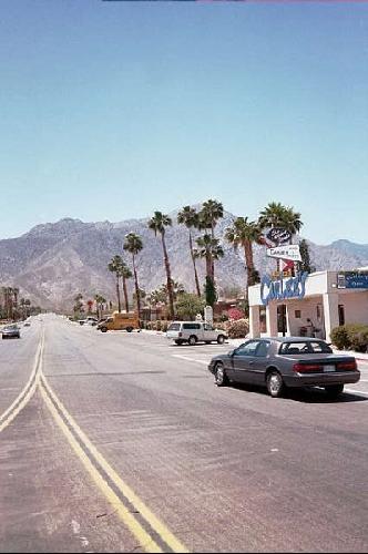
Borrego Springs area (33.441 -116.362)
/Big Bear/Coachella (Most of these symptoms
were overnight and I am sure I missed some.
They were almost charley horses but there
were many of them. This could be a large
swarm of small quakes but I am putting it
at - VERY STRONG.)
www.virtualtourist.com
--------------------------------------
1.6 2007/01/07 23:46:42 33.029 -116.032 3.6 16 km( 10 mi) SE of Ocotillo Wells, CA
2.8 2007/01/07 11:16:13 33.891 -116.961 8.4 4 km ( 2 mi) SSE of Beaumont, CA
1.1 2007/01/07 05:32:25 33.343 -116.257 16.0 15 km( 9 mi) NE of Borrego Springs, CA
1.1 2007/01/07 04:32:43 33.542 -116.831 0.0 15 km ( 9 mi) W of Anza, CA
1.4 2007/01/07 04:11:45 33.462 -116.572 17.1 14 km ( 9 mi) SE of Anza, CA
2.8 2007/01/08 03:05:34 33.624 -116.758 19.2 11 km ( 7 mi) NW of Anza, CA
1.4 2007/01/08 08:58:07 33.725 -116.839 18.7 6 km ( 4 mi) ESE of Valle Vista, CA
2.0 2007/01/08 13:36:57 33.572 -116.628 17.7 4 km ( 3 mi) ENE of Anza, CA
1.8 2007/01/08 22:58:09 33.246 -116.113 12.9 12 km ( 7 mi) N of Ocotillo Wells, CA
(Nothing very big)
Hawaii (2 new symptoms for the
area - STRONG)
--------------------------------------
2.2 2007/01/07 03:51:45 19.815 -154.948 16.5 16 km ( 10 mi) E of Papaikou, HI
1.9 2007/01/07 21:11:46 19.888 -156.106 12.5 21 km ( 13 mi) NNW of Kalaoa, HI
Northern Sumatra and
then Southern Sumatra
--------------------------------------
2007-01-08 12:48:38.6 8.11N 92.49E 10 Mw6.1 NICOBAR ISLANDS, INDIA REGION
(Nothing found for Southern Sumatra)
The Parkfield Fault/Central area
--------------------------------------
1.0 2007/01/07 20:49:13 36.550 -121.144 6.6 2 km ( 1 mi) N of Pinnacles, CA
2.0 2007/01/07 20:39:37 35.929 -120.478 5.0 5 km ( 3 mi) NW of Parkfield, CA
1.3 2007/01/07 19:00:04 36.549 -121.144 6.4 2 km ( 1 mi) N of Pinnacles, CA
1.6 2007/01/07 18:56:00 36.549 -121.143 6.5 2 km ( 1 mi) N of Pinnacles, CA
1.7 2007/01/07 18:37:28 36.550 -121.143 6.9 2 km ( 1 mi) N of Pinnacles, CA
2.2 2007/01/07 18:26:27 36.550 -121.143 6.5 2 km ( 1 mi) N of Pinnacles, CA
1.4 2007/01/07 17:32:39 36.223 -120.274 11.9 12 km ( 7 mi) NE of Coalinga, CA
1.3 2007/01/08 00:29:53 35.669 -121.026 6.4 14 km ( 9 mi) NNE of Cambria, CA
2.2 2007/01/08 00:05:36 35.668 -121.037 6.8 13 km ( 8 mi) NNE of Cambria, CA
The Strait of Gibraltar
(Very Strong)
www.travel-images.com
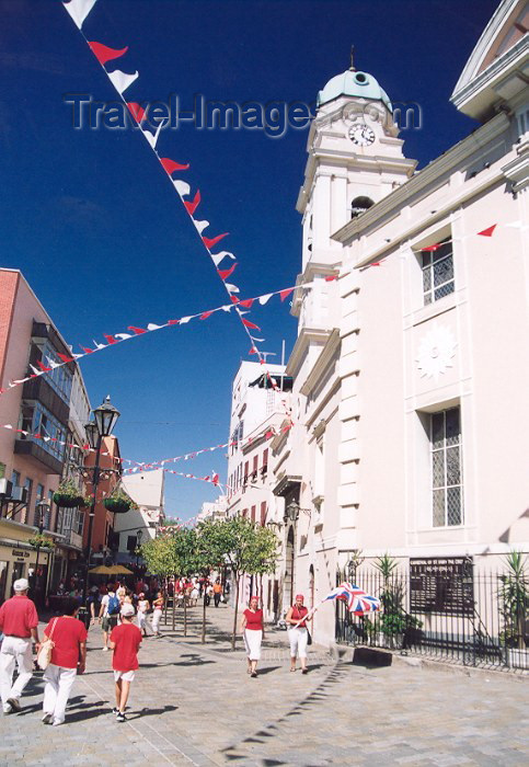
--------------------------------------
(Nothing found)
France to Northern Italy
(Very Strong)
www.urban75.org

--------------------------------------
2007-01-08 11:36:54.8 47.06N 0.42E 5 ML3.7 FRANCE
2007-01-08 14:51:14.5 42.94N 0.31E 2 ML2.8 PYRENEES
Puerto Rico/Virgin Islands
(Strong)
--------------------------------------
3.1 2007/01/07 20:30:52 19.366N -65.108W 5.0 109 km (68 mi) NW of Settlement, Anegada, British Virgin Islands
3.3 2007/01/07 10:45:44 19.400N -65.167W 5.2 116 km (72 mi) NW of Settlement, Anegada, British Virgin Islands
3.1 2007/01/07 09:40:17 18.621N -64.956W 14.3 30 km (19 mi) N of Charlotte Amalie, Saint Thomas, US Virgin Islands
3.2 2007/01/07 09:06:06 19.443N -65.178W 20.6 120 km (75 mi) NW of Settlement, Anegada, British Virgin Islands
3.4 2007/01/07 03:32:30 19.370N -65.140W 5.8 112 km (69 mi) NW of Settlement, Anegada, British Virgin Islands
3.1 2007/01/07 03:16:04 19.170N -65.282W 18.6 96 km (60 mi) N of Culebra, PR
3.4 2007/01/07 03:08:02 19.395N -65.103W 62.4 111 km (69 mi) NW of Settlement, Anegada, British Virgin Islands
3.0 2007/01/07 03:06:27 19.124N -65.100W 93.9 87 km (54 mi) NNW of Little Harbour, Jost van Dyke, British Virgin Islands
3.3 2007/01/07 02:35:15 19.327N -65.141W 44.5 109 km (68 mi) NW of Settlement, Anegada, British Virgin Islands
3.0 2007/01/07 02:32:04 19.264N -65.207W 7.3 105 km (66 mi) NNW of Charlotte Amalie, Saint Thomas, US Virgin Islands
3.1 2007/01/07 02:31:04 19.163N -65.177W 68.6 94 km (58 mi) NNW of Charlotte Amalie, Saint Thomas, US Virgin Islands
3.0 2007/01/07 02:29:52 19.381N -65.111W 58.8 110 km (68 mi) NW of Settlement, Anegada, British Virgin Islands
2.8 2007/01/07 02:29:05 19.477N -65.200W 25.0 124 km (77 mi) NW of Settlement, Anegada, British Virgin Islands
3.3 2007/01/07 02:26:48 19.365N -65.174W 25.3 114 km (71 mi) NW of Settlement, Anegada, British Virgin Islands
4.4 2007/01/07 02:15:34 19.256N -65.109W 64.5 101 km (63 mi) NNW of Little Harbour, Jost van Dyke, British Virgin Islands
3.4 2007/01/07 00:53:30 19.366N -64.906W 7.2 94 km (58 mi) NW of Settlement, Anegada, British Virgin Islands
3.8 2007/01/07 00:00:04 19.290N -65.186W 2.6 108 km (67 mi) NNW of Charlotte Amalie, Saint Thomas, US Virgin Islands
Guererro, Mexico (Second day
system - Strong)
--------------------------------------
2007/01/07 11:41:19 15.88 98.94 28 4.2 106 km al SUROESTE de OMETEPEC, GRO
Southern Iran (Strong)
--------------------------------------
2007-01-07 12:46:07.4 28.07N 52.13E 18 M3.4 SOUTHERN IRAN
2007-01-07 15:32:25.0 34.57N 57.02E 15 mb4.8 NORTHEASTERN IRAN
2007-01-07 15:57:42.5 28.44N 52.22E 28 M3.2 SOUTHERN IRAN
2007-01-07 18:25:18.4 33.99N 56.64E 10 M3.6 CENTRAL IRAN
Honshu, Japan area
--------------------------------------
2007-01-06 23:06:54.4 24.37N 140.52E 33 mb4.5 VOLCANO ISLANDS, JAPAN REGION
Mariana Islands area
--------------------------------------
07Jan2007 01:22:41.6 12.4N 143.8E 33 mb=5.0 M*GSR SOUTH OF MARIANA ISLANDS
The Geysers (MEDIUM)
--------------------------------------
2.2 2007/01/07 02:44:19 38.817 -122.818 2.7 2 km ( 1 mi) NNW of The Geysers, CA
1.4 2007/01/07 05:30:58 38.818 -122.817 2.8 2 km ( 1 mi) NNW of The Geysers, CA
3.1 2007/01/07 09:20:38 38.390 -122.615 8.8 8 km ( 5 mi) WNW of Glen Ellen, CA
1.5 2007/01/07 15:14:50 38.819 -122.801 2.7 2 km ( 1 mi) N of The Geysers, CA
1.4 2007/01/07 15:54:09 38.812 -122.776 0.0 3 km ( 2 mi) ENE of The Geysers, CA
1.2 2007/01/08 21:29:59 38.820 -122.801 2.6 2 km ( 2 mi) NNE of The Geysers, CA
1.6 2007/01/08 11:53:01 38.832 -122.794 1.2 4 km ( 2 mi) NNE of The Geysers, CA
1.3 2007/01/08 11:14:15 38.841 -122.803 1.1 5 km ( 3 mi) N of The Geysers, CA
2.0 2007/01/08 10:20:47 38.824 -122.798 2.6 3 km ( 2 mi) NNE of The Geysers, CA
South of Alaska (Indication of
depth - Strong)
--------------------------------------
5.8 2007/01/05 16:52:18 55.436 -155.486 15.0 SOUTH OF ALASKA
(2 days early)
3.4 2007/01/06 14:01:27 59.277 -145.079 15.0 GULF OF ALASKA
5.0 2007/01/07 15:33:44 54.966 -157.015 10.0 SOUTH OF ALASKA
SOUTHEASTERN SIBERIA, RUSS
(57.6N 120.8E)(Strong)
--------------------------------------
(Nothing found)
Mt. St. Helen’s (Medium)
--------------------------------------
1.4 2007/01/06 11:06:52 46.198N 122.194W 0.8 1 km ( 1 mi) W of Mount St. Helens Volcano, WA
1.4 2007/01/07 22:25:52 46.198N 122.200W 0.0 2 km ( 1 mi) W of Mount St. Helens Volcano, WA
1.8 2007/01/08 21:51:17 46.196N 122.197W 0.6 1 km ( 1 mi) WSW of Mount St. Helens Volcano, WA
1.8 2007/01/08 19:03:07 46.860N 121.909W 9.8 14 km ( 9 mi) NE of Ashford, WA
1.8 2007/01/08 11:29:33 46.196N 122.188W 0.0 1 km ( 0 mi) SW of Mount St. Helens Volcano, WA
1.5 2007/01/08 05:34:24 46.196N 122.196W 0.3 1 km ( 1 mi) WSW of Mount St. Helens Volcano, WA
Turkey/Greece/Macedonia/Bulgaria area
--------------------------------------
2007-01-07 01:57:41.1 40.65N 20.72E 2G ML2.7 ALBANIA
2007-01-07 03:39:38.5 37.76N 32.36E 5 MD3.0 CENTRAL TURKEY
2007-01-07 12:14:16.4 38.32N 22.06E 1G ML2.9 GREECE
2007-01-07 14:47:03.9 38.41N 22.03E 2 ML4.1 GREECE
2007-01-07 15:30:35.2 38.34N 22.10E 1G ML3.1 GREECE
2007-01-07 15:56:21.5 38.30N 22.09E 2f ML3.4 GREECE
2007-01-07 16:28:53.9 38.16N 20.58E 1G ML3.2 GREECE
2007-01-07 17:54:24.0 38.80N 22.30E ML2.9 GREECE
2007-01-07 23:25:52.4 39.54N 25.69E 5 MD3.2 AEGEAN SEA
2007-01-07 22:19:15.3 40.77N 30.35E 10 ML3.4 WESTERN TURKEY
2007-01-07 22:18:03.2 32.78N 47.46E 6 M3.7 IRAN-IRAQ BORDER REGION
2007-01-07 22:11:17.2 38.98N 33.40E 10 MD2.8 CENTRAL TURKEY
2007-01-07 20:52:01.0 39.00N 22.20E ML2.6 GREECE
2007-01-07 19:54:48.8 37.11N 36.10E 8 MD3.3 CENTRAL TURKEY
2007-01-07 19:47:16.5 37.83N 43.58E 9 MD3.3 TURKEY-IRAQ BORDER REGION
2007-01-08 23:33:22.7 40.42N 28.99E 5 MD3.1 WESTERN TURKEY
2007-01-08 22:22:32.1 39.12N 27.25E 7 MD3.0 WESTERN TURKEY
2007-01-08 20:42:05.0 39.09N 25.29E ML3.0 AEGEAN SEA
2007-01-08 05:43:50.3 39.58N 25.82E 5 MD3.2 AEGEAN SEA
2007-01-08 05:15:40.9 39.48N 25.94E 5 ML3.4 AEGEAN SEA
2007-01-08 05:07:24.1 39.50N 25.83E 10 ML3.6 AEGEAN SEA
2007-01-08 04:26:58.3 39.56N 25.64E 5 MD3.2 AEGEAN SEA
2007-01-08 03:44:43.3 39.56N 25.80E 5 ML3.6 AEGEAN SEA
2007-01-08 03:35:45.7 39.48N 25.82E 10 ML4.4 AEGEAN SEA
2007-01-08 03:15:29.1 39.62N 25.68E 10 MD3.3 AEGEAN SEA
2007-01-08 00:57:04.1 38.06N 30.18E 7 MD3.1 WESTERN TURKEY
Peace to all.

posted by Unknown @ 2:28 PM
0 comments
![]()
![]()
