*For Monday, 23 January 2006.
LEGEND for OVERVIEW:
Size = My surety of area for quake.
Red Circle = Probable quake to STRONG quake.
Triangle = Very Strong or Stronger quake (And usually takes extra days).
Blue Circle, etc. = Uncertainty of symptom area for probable quake.
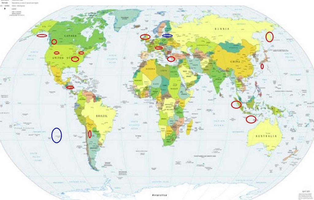
Places to watch.
Good luck to all.
For Monday, 23 January 2006.
----------------------------------------
New Madrid Fault
----------------------------------------
(Nothing found)
South of Java, Indonesia (9.2S 107.6E) then Sumatra (Strong for both areas)
----------------------------------------
MAP 4.4 2006/01/24 15:49:33 -9.938 120.755 26.6 SUMBA REGION, INDONESIA
MAP 4.8 2006/01/26 14:27:54 1.919 96.625 29.7 NIAS REGION, INDONESIA
MAP 5.3 2006/01/26 23:58:02 -4.809 102.786 51.7 SOUTHERN SUMATRA, INDONESIA
(2 extra days)
Yellowstone area (Medium)
----------------------------------------
ap 1.2 2006/01/24 22:44:07 39.658N 110.534W 2.1 16 km (10 mi) NW of E. Carbon City, UT
map 1.3 2006/01/24 19:41:33 44.638N 110.142W 1.4 20 km (13 mi) ENE of Fishing Bridge, WY
map 1.0 2006/01/24 19:40:17 44.644N 110.146W 1.4 20 km (13 mi) ENE of Fishing Bridge, WY
map 0.6 2006/01/24 17:37:00 44.538N 110.947W 12.1 13 km ( 8 mi) NW of Old Faithful, WY
map 1.0 2006/01/24 17:36:42 44.533N 110.962W 7.2 13 km ( 8 mi) NW of Old Faithful, WY
map 1.8 2006/01/24 14:13:01 40.744N 112.166W 2.9 2 km ( 1 mi) N of Garfield, UT
map 1.1 2006/01/24 14:01:54 44.369N 110.963W 8.3 14 km ( 9 mi) SW of Old Faithful, WY
map 1.3 2006/01/24 14:01:10 44.380N 110.991W 3.2 15 km (10 mi) SW of Old Faithful, WY
map 1.4 2006/01/24 13:57:10 44.376N 110.983W 3.1 15 km ( 9 mi) SW of Old Faithful, WY
map 1.9 2006/01/24 13:38:48 44.390N 111.034W 2.4 18 km (11 mi) WSW of Old Faithful, WY
map 1.4 2006/01/24 13:35:26 44.332N 111.051W 8.2 22 km (14 mi) SW of Old Faithful, WY
map 1.5 2006/01/24 13:20:30 39.407N 111.217W 4.4 24 km (15 mi) WNW of Huntington, UT
map 1.5 2006/01/24 12:34:28 39.412N 111.223W 4.5 24 km (15 mi) WNW of Huntington, UT
map 1.5 2006/01/24 10:52:25 39.415N 111.225W 2.4 24 km (15 mi) ESE of Spring City, UT
map 1.1 2006/01/23 22:41:50 39.388N 111.072W 4.8 12 km ( 7 mi) NW of Huntington, UT
map 2.1 2006/01/23 17:18:54 38.664N 109.464W 7.0 13 km ( 8 mi) NE of Moab, UT
map 1.8 2006/01/23 13:55:37 39.712N 110.739W 0.2 10 km ( 6 mi) ENE of Helper, UT
map 1.7 2006/01/23 13:54:49 39.417N 111.223W 6.6 24 km (15 mi) WNW of Huntington, UT
Northern Italy to Austria area (Second day of symptoms - STRONG)
----------------------------------------
2006-01-23 21:29:04.2 45.78N 15.73E 5 ML3.3 NORTHWESTERN BALKAN PEN.
24Jan2006 05:23:20.9 47.6N 8.9E 20 ML=1.7 M*LED ANDELFINGEN / SWITZERLAND 0850
Kyushu/Ryukyu, Japan area (MEDIUM)
----------------------------------------
2006-01-24 00:36:48.8 25.87 N 142.53 E 40 mb 5.2 VOLCANO ISLANDS, JAPAN, REGION
(More South than thought)
Possibly Easter Island area (Medium)
----------------------------------------
(Nothing found)
Possibly Latvia area (Second day - Strong)
----------------------------------------
BALTIC STATES-BELARUS-NW RUSSIA REGION
Origin time Lat Lon Azres Timres Wres Nphase Ntot Nsta Netmag
2006-022:14.28.32.0 52.02 45.06 22.09 0.78 6.30 3 3 2 2.51
BALTIC STATES-BELARUS-NW RUSSIA REGION
Origin time Lat Lon Azres Timres Wres Nphase Ntot Nsta Netmag
2006-022:22.32.45.0 57.21 46.27 8.70 0.10 2.27 2 2 1 2.50
BALTIC STATES-BELARUS-NW RUSSIA REGION
Origin time Lat Lon Azres Timres Wres Nphase Ntot Nsta Netmag
2006-023:01.28.36.0 68.76 62.12 5.70 0.44 1.86 4 5 2 2.52
BALTIC STATES-BELARUS-NW RUSSIA REGION
Origin time Lat Lon Azres Timres Wres Nphase Ntot Nsta Netmag
2006-023:10.02.06.0 59.08 44.54 20.10 0.61 5.63 2 2 1 2.85
Lake Erie (Possibly West of Cleveland) (Medium)
----------------------------------------
(Nothing found)
Jujuy, Argentina (-24.015 -66.727)
----------------------------------------
MAP 4.6 2006/01/27 10:03:38 -22.366 -68.659 109.9 ANTOFAGASTA, CHILE
Greece/Turkey area (Medium)
----------------------------------------
2006-01-22 05:35:18.0 35.38 N 26.47 E 30ML 3.8 CRETE, GREECE
2006-01-22 10:44:20.1 38.68 N 25.66 E 30MD 3.0 AEGEAN SE
2006-01-22 17:17:34.0 36.12 N 22.54 E25ML 3.5 SOUTHERN GREECE
2006-01-22 19:04:21.5 36.00 N 23.88 E 73ML 3.6 SOUTHERN GREECE
2006-01-22 22:41:50.0 35.22 N 25.44 E ML 3.3 CRETE, GREECE
2006-01-23 03:26:23.0 36.23 N 28.62 E ML 3.4 DODECANESE ISLANDS, GREECE
2006-01-23 09:39:20.1 38.99 N 20.48 E49fML 3.6 GREECE
2006-01-23 10:34:55.1 35.98 N 26.20 E60ML 3.6 CRETE, GREECE
2006-01-23 16:13:27.6 39.80 N 26.65 E 19MD 3.1 TURKEY
2006-01-23 17:20:34.5 39.14 N 31.75 E21MD 2.9 TURKEY
2006-01-23 21:57:38.0 34.40 N 25.55 E ML 3.0 CRETE, GREECE
England/Ireland area
----------------------------------------
EASTERN NORTH SEA
Origin time Lat Lon Azres Timres Wres Nphase Ntot Nsta Netmag
2006-023:06.59.57.0 55.00 6.17 11.90 0.15 3.12 2 2 1 2.88
NORTHWESTERN NORTH SEA
Origin time Lat Lon Azres Timres Wres Nphase Ntot Nsta Netmag
2006-023:08.24.12.0 55.24 -0.43 13.08 3.29 6.56 3 3 2 1.75
British Columbia, Canada
----------------------------------------
2006/01/22 06:33:23 50.10N 127.87W 20 1.0 75 km SSW Pt. Hardy BC
2006/01/22 06:22:60 48.53N 122.59W 17 0.9 58 km ENE Victoria BC
Gulf of Alaska
----------------------------------------
map 3.6 2006/01/24 08:48:48 56.294 -148.106 15.0 GULF OF ALASKA
Nicaragua
----------------------------------------
06/01/23 14:45:33 12.69N 86.82W 4.5 1.3MC Nicaragua
06/01/23 14:33:51 12.57N 86.75W 5.8 1.7MC Cerca del Volcan Cerro Negro
06/01/23 11:47:38 12.65N 86.65W 5.9 2.1MC Nicaragua
06/01/23 05:59:09 12.12N 85.05W 45.3 2.6ML Nicaragua
Kamchatka (MEDIUM)
----------------------------------------
2006-01-24 15:56:34.2 51.12N 157.33E 85Ms 3.8 NEAR E. CST KAMCHATKA PEN.
Peace to all.

posted by Unknown @ 1:41 PM
0 comments
![]()
![]()
