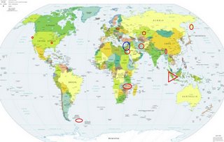
*For Thursday, 8 June 2006.
LEGEND for OVERVIEW: Size = My surety of area for quake.
Red Circle = Probable quake to STRONG quake.
Triangle = Very Strong or Stronger quake (And usually takes extra days).
Blue Circle, etc. = Uncertainty of symptom area for probable quake.

Places to watch.
Good luck to all.
For Thursday, 8 June 2006.
----------------------------------------
The New Madrid Faut
----------------------------------------
MAP 2.1 2006/06/07 11:28:44 36.610 -89.610 6.6 1 km ( 1 mi) NE of North Lilbourn, MO
Possibly Cyprus/Syria to Israel/Egypt area (New symptom area with an indication of depth - STRONG.)
----------------------------------------
(Nothing found)
Red Sea/Egypt area (17.86N 40.20E) (Second day for this symptom and an indication of depth -STRONG.)
----------------------------------------
DUST OVER THE RED SEA
A dust storm blew across the Red Sea on June 9, 2006.
* http://naturalhazards.nasa.gov/shownh.php3?img_id=13634>image
*** MODIS(Terra) image from Jun 09 2006 (Posted on Jun 09 2006 3:29PM)
2006-06-15 11:17:00 4.9 29.53 N 30.42 E Egypt
(7 extra days)
Myanmar (24.02 N 94.81 E)
----------------------------------------
(Nothing found)
Northcentral Iran (Medium)
----------------------------------------
2006-06-07 01:46:53.7 26.63 N 53.30 E 8 M 3.2 SOUTHERN IRAN
2006-06-07 04:42:13.1 37.16 N 57.34 E 17 M 3.2 IRAN-TURKMENISTAN BORDER REG
Kamchatka
----------------------------------------
6Jun2006 03:30:12.2 47.2N 153.7E 90 mb=4.9 M*GSR KURIL ISLANDS
06Jun2006 04:42:56.0 44.3N 147.0E110 mb=4.9 M GSR KURIL ISLANDS
(2 days early and much more south than expected.)
Scotia Sea (60.40 S 42.64 W)
----------------------------------------
2006-06-09 23:17:28 5.6 47.52 S 32.07 E Prince Edward Islands Region
2006-06-09 23:17:28 5.6 47.56 S 31.59 E South of Africa
2006-06-09 23:17:28 5.6 47.46 S 31.79 E South of Africa
(Opposite? - this is a difficult symptom area to pinpoint.)
Kazakhstan area (47.20N 64.35E)
----------------------------------------
2006-06-08 08:06:43.0 48.57 N 63.37 E ML 3.0 WESTERN KAZAKHSTAN
Off the Coast of California on the lattitude of The Geysers
----------------------------------------
MAP 2.0 2006/06/07 17:01:42 38.953 -123.346 4.1 25 km ( 15 mi) SSW of Ukiah, CA
MAP 3.2 2006/06/08 23:02:16 40.736 -124.588 13.4 32 km ( 20 mi) W of Humboldt Hill, CA
MAP 2.6 2006/06/09 21:36:18 41.337 -124.320 28.3 33 km ( 21 mi) SW of Klamath, CA
(Not on the lattitude of The Geysers.)
Poland
----------------------------------------
2006-06-08 05:11:09.5 50.15 N 18.43 E 10 ML 2.0 POLAND
2006-06-08 10:58:09.7 52.49 N 14.76 E 10 f ML 2.3 POLAND
2006-06-10 04:07:15.3 50.15 N 18.43 E 10 ML 2.5 POLAND
(2 extra days)
Mozambique area and West of
----------------------------------------
2006-06-08 06:17:22.8 21.31 S 33.44 E 2 mb 4.8 MOZAMBIQUE
2006-06-10 20:25:26.7 4.77 S 29.02 E 80 mb 4.8 LAKE TANGANYIKA REGION
(2 extra days)
Northern to Southern Sumatra (VERY STRONG)
http://rapidfire.sci.gsfc.nasa.gov/gallery/?2004364-1229/Sumatra.A2004364.0405.250m.jpg>rapidfire

----------------------------------------
2006-06-08 04:23:22.2 2.64 N 96.90 E 40 mb 4.8 NORTHERN SUMATERA, INDONESIA
Peace to all.

