*For Saturday, 5 November 2005.
Places to watch.
Good luck to all.
For Saturday, 5 November 2005.
----------------------------------------
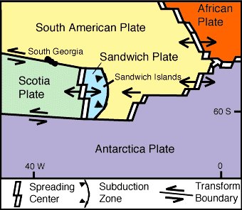
South Sandwich Islands area (I have been getting symptoms for this area for a week or more. This day was the strongest so I think EXTREMELY STRONG and might take extra days.)
http://volcano.und.edu/vwdocs/volc_images/south_america/south_sandwich_islands.htmlSouth Sandwich Islands
----------------------------------------
(Came in on the 7th and posting it on the 6th list.)
Ethiopia
----------------------------------------
2005/11/05 00:21:08.4 11.82 N 43.70 E ML4.7 ETHIOPIA
2005/11/05 00:26:25.0 11.95 N 43.67 E 10 ML4.0 ETHIOPIA
2005/11/05 00:55:07.5 12.05 N 43.74 E 2 ML3.7 WESTERN ARABIAN PENINSULA
2005/11/05 01:56:26.3 12.10 N 43.56 E 2 ML3.7 WESTERN ARABIAN PENINSULA
2005/11/05 02:14:37.7 12.02 N 43.53 E 3 ML3.7 WESTERN ARABIAN PENINSULA
2005/11/05 06:20:08.1 12.11 N 43.62 E 6 ML3.3 WESTERN ARABIAN PENINSULA
2005/11/06 03:46:18.9 11.96 N 43.53 E 3 ML4.5 ETHIOPIA
2005/11/06 12:11:09.8 11.74 N 43.61 E 7 ML5.0 ETHIOPIA
Hawaii and South of - possibly Line Islands (Medium)
----------------------------------------
map 2.0 2005/11/05 22:53:26 19.444 -155.247 28.0 1 km ( 1 mi) WSW of Volcano, HI
Finland/Sweden area (STRONG)
----------------------------------------
CENTRAL NORBOTTEN SWEDEN
Origin time Lat Lon Azres Timres Wres Nphase Ntot Nsta Netmag
2005-309:00.20.55.0 67.79 20.10 5.15 1.39 2.68 7 14 4 2.24
CENTRAL NORBOTTEN SWEDEN
Origin time Lat Lon Azres Timres Wres Nphase Ntot Nsta Netmag
2005-309:00.18.15.0 68.09 18.80 13.64 0.99 4.40 6 11 3 2.06
GAEVLEBORG REGION SWEDEN
Origin time Lat Lon Azres Timres Wres Nphase Ntot Nsta Netmag
2005-309:09.51.56.0 60.24 14.30 8.66 0.99 3.15 3 8 3 3.03
SOUTHWESTERN FINLAND FINLAND
Origin time Lat Lon Azres Timres Wres Nphase Ntot Nsta Netmag
2005-309:10.42.50.0 60.94 24.82 14.36 5.05 8.64 3 3 2 2.05
Sumatra, Indonesia (Strong)
----------------------------------------
2005/11/05 14:37:03.0 9.78 S 117.99 E 33 mb5.5 SUMBAWA, INDONESIA, REGION
Mariana Islands area (Medium)
----------------------------------------
2005/11/06 01:57:03.5 12.28 N 144.06 E 40 mb5.1 SOUTH OF MARIANA ISLANDS
Afghanistan-Tajikistan Border Region
----------------------------------------
2005/11/05 18:19:14.0 37.91 N 72.53 E ML4.4 TAJIKISTAN
Turkey (Strong)
----------------------------------------
2005/11/05 00:21:53.1 38.09 N 26.64 E 8 MD3.1 AEGEAN SEA
2005/11/05 05:29:35.2 38.19 N 26.73 E 12 MD3.0 AEGEAN SEA
2005/11/05 07:10:57.0 38.13 N 26.78 E 14 MD3.3 AEGEAN SEA
2005/11/05 09:35:04.7 38.15 N 38.47 E 31 MD3.0 TURKEY
2005/11/05 10:11:27.8 38.21 N 26.76 E 26 MD3.2 AEGEAN SEA
2005/11/05 11:35:47.2 37.48 N 42.94 E 18 MD3.7 TURKEY
2005/11/05 10:55:35.2 38.11 N 26.73 E 14 MD3.3 AEGEAN SEA
2005/11/05 15:27:13.9 38.20 N 26.68 E 15 MD3.8 AEGEAN SEA
2005/11/05 15:20:58.3 38.93 N 31.14 E 29 MD2.9 TURKEY
2005/11/05 17:48:27.2 39.06 N 31.14 E 5 ML3.8 TURKEY
2005/11/05 17:36:23.9 39.03 N 31.14 E 3 MD3.5 TURKEY
2005/11/05 17:24:31.1 39.06 N 31.12 E 5 MD3.5 TURKEY
2005/11/05 16:57:15.2 39.39 N 33.16 E 8 MD2.9 TURKEY
2005/11/05 19:35:52.8 38.22 N 26.84 E 15 MD3.1 AEGEAN SEA
2005/11/05 18:52:49.5 39.02 N 31.14 E 9 MD2.8 TURKEY
2005/11/05 22:44:42.8 38.12 N 26.85 E 12 MD3.0 AEGEAN SEA
2005/11/06 05:23:28.4 39.49 N 39.73 E 26 MD3.2 TURKEY
2005/11/06 04:59:31.0 38.10 N 42.57 E 5 ML3.8 TURKEY
2005/11/06 05:56:55.7 38.21 N 26.66 E 20 MD3.0 AEGEAN SEA
2005/11/06 07:42:27.0 39.21 N 23.35 E ML3.1 AEGEAN SEA
2005/11/06 08:51:08.4 37.03 N 36.10 E 29 MD3.0 TURKEY
2005/11/06 11:45:14.3 37.21 N 36.89 E 12 MD2.9 TURKEY
2005/11/06 12:21:44.9 37.08 N 30.46 E 25 mb4.3 TURKEY
2005/11/06 22:27:53.3 39.68 N 38.33 E 18 MD3.3 TURKEY
New Madrid Fault
----------------------------------------
map 1.6 2005/11/06 20:24:19 36.250N 89.450W 5.5 4 km ( 2 mi) ESE of Ridgely, TN
map 1.5 2005/11/06 18:17:05 36.250N 89.450W 5.7 4 km ( 2 mi) ESE of Ridgely, TN
Nicaragua
----------------------------------------
05/11/05 23:44:16 11.36N 84.31W 5.0 3.0ML Nicaragua
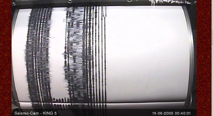
Mt. St. Helen's (Very Strong)
----------------------------------------
map 1.0 2005/11/06 06:04:58 46.196N 122.194W 0.4 0 km ( 0 mi) SW of Mount St. Helens
map 2.9 2005/11/06 17:24:12 46.196 -122.194 0.6 1 km ( 1 mi) WSW of Mount St. Helens Volcano, WA
(Here is a picture of the seismodrum for this day...obviously, USGS is not posting quakes.)
Honshu, Japan and South of the area (Possibly volcanic)
----------------------------------------
(Came in on the 7th and I posted them on the 6th list.)
Ontario to New Brunswick, Canada area (STRONG)
----------------------------------------
2005/11/06 21:53:57 47.51N 65.90W 0.0g 1.7MN GSC Probable blast, Bronswick mine, NB
2005/11/06 04:53:17 60.04N 75.94W 18.0g 2.2MN GSC 75 km E from Puvirnituq, QC
2005/11/06 02:55:14 47.50N 70.08W 17.4 1.4MN GSC CHARLEVOIX SEISMIC ZONE, QUE.
Utah/Nevada
----------------------------------------
map 1.7 2005/11/05 03:32:39 39.731 -110.752 0.2 10 km ( 6 mi) ENE of Helper, UT
map 1.6 2005/11/05 08:21:55 38.233 -112.558 0.3 9 km ( 5 mi) SE of Beaver, UT
map 1.9 2005/11/05 16:26:55 39.711 -110.737 0.0 11 km ( 7 mi) ENE of Helper, UT
map 1.9 2005/11/05 18:43:41 38.213 -118.384 9.6 16 km ( 10 mi) SE of Qualeys Camp, NV
map 1.5 2005/11/05 20:47:40 40.238 -111.895 7.9 10 km ( 6 mi) S of Saratoga Springs, UT
map 1.6 2005/11/05 20:51:16 39.444 -119.624 0.0 16 km ( 10 mi) SE of Sparks, NV
map 1.6 2005/11/05 23:59:38 39.712 -110.738 0.2 11 km ( 7 mi) ENE of Helper, UT
Puerto Rico area (Strong)
----------------------------------------
MAP 3.4 2005/11/05 02:17:18 18.889 -64.302 21.6 18 km ( 11 mi) N of Settlement, British Virgin Islands
map 1.6 2005/11/05 08:22:53 17.916 -66.947 8.4 7 km ( 4 mi) SSW of Guánica, PR
Central Alaska
----------------------------------------
map 2.9 2005/11/05 16:28:34 63.445 -151.229 1.0 CENTRAL ALASKA
map 3.6 2005/11/05 20:27:54 63.072 -150.599 120.0 CENTRAL ALASKA
map 2.6 2005/11/06 01:45:22 63.521 -147.086 1.0 CENTRAL ALASKA
map 2.8 2005/11/06 08:09:00 62.492 -150.947 100.0 CENTRAL ALASKA
map 2.5 2005/11/06 10:58:03 62.833 -148.975 50.0 CENTRAL ALASKA
map 2.9 2005/11/06 14:59:21 62.228 -145.492 1.0 CENTRAL ALASKA
Southern Xinjiang, China (STRONG)
----------------------------------------
(Nothing found)
Montana/Idaho
----------------------------------------
map 1.3 2005/11/05 08:59:45 44.631 -110.344 2.2 54 km ( 33 mi) SW of Cooke City-Silver Gate, MT
Pinnacles (STRONG - maybe a swarm.)
----------------------------------------
(Nothing found)
Peace to all.

posted by Unknown @ 11:52 AM
0 comments
![]()
![]()
