*For Wednesday,15 March 2006.
LEGEND for OVERVIEW:
Size = My surety of area for quake.
Red Circle = Probable quake to STRONG quake.
Triangle = Very Strong or Stronger quake (And usually takes extra days).
Blue Circle, etc. = Uncertainty of symptom area for probable quake.
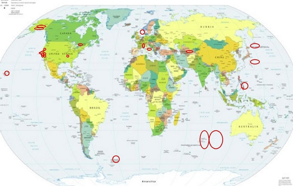
Places to watch.
Good luck to all.
For Wednesday,15 March 2006.
----------------------------------------
Southeast Indian Ocean (Second day symptom - STRONG)
----------------------------------------
15Mar2006 09:40:59.0 0.9S 67.4E 33 mb=4.6 M GSR CARLSBERG RIDGE (More Northern
than expected)
MAP 4.4 2006/03/15 18:09:00 -20.899 32.895 10.0 ZIMBABWE
Uzbekistan area (Medium)
----------------------------------------
2006-03-15 07:15:45.0 51.80 N 79.85 E ML 3.2 EASTERN KAZAKHSTAN
(More East than expected)
East of San Francisco then San Francisco (The symptoms for San Francisco persist - Extremely Strong.)
http://www.du.edu/~ajenniso/SFPhotIndex.html>Monteray
----------------------------------------
(Still nothing found - symptoms have stopped on 19 March.)
Southern Alaska then Alaska Peninsula (Medium for both)
----------------------------------------
MAP 3.1 2006/03/15 11:48:03 60.118 -153.320 100.0 SOUTHERN ALASKA
MAP 2.9 2006/03/16 19:02:06 61.427 -147.491 20.0 SOUTHERN ALASKA
MAP 2.6 2006/03/16 16:01:38 61.500 -150.209 20.0 SOUTHERN ALASKA
MAP 3.1 2006/03/16 10:35:35 61.871 -147.137 35.0 SOUTHERN ALASKA
MAP 4.8 2006/03/17 20:54:36 60.722 -151.951 80.2 KENAI PENINSULA, ALASKA
(2 extra days)
The Parkfield Fault (Medium)
----------------------------------------
MAP 1.0 2006/03/15 17:05:42 36.612 -121.219 5.1 11 km ( 7 mi) NW of Pinnacles, CA
MAP 1.0Q 2006/03/15 19:39:09 36.749 -121.593 0.0 0 km ( 0 mi) NNE of Quarry near Natividad, CA(Probable quarry explosion)
Willow Creek, CA (40.699 -123.783) area
----------------------------------------
(Nothing found)
Banning, California area (33.921 -116.835) (Strong)
----------------------------------------
MAP 1.7 2006/03/15 21:52:10 33.929 -117.211 14.0 2 km ( 1 mi) ENE of Moreno Valley, CA
MAP 1.6 2006/03/15 21:12:35 33.933 -117.218 14.0 1 km ( 1 mi) NE of Moreno Valley, CA
MAP 1.6 2006/03/15 19:40:08 33.940 -117.141 16.2 8 km ( 5 mi) E of Moreno Valley, CA
MAP 1.4 2006/03/15 11:24:40 33.979 -116.943 17.0 7 km ( 4 mi) NW of Banning, CA
Mid-Indian Ridge (-40.131 78.473) (Medium)
----------------------------------------
(Nothing found)
France/Switzerland border area
----------------------------------------
2006-03-16 03:06:08.4 42.32N 1.42E 2 ML 2.6 PYRENEES
2006-03-15 01:45:51.0 45.81N 0.73W 10 ML2.4 FRANCE
2006-03-15 10:30:17.5 46.11N 3.52E 10 ML2.2 FRANCE
Hawaii
----------------------------------------
MAP 1.7 2006/03/15 23:54:55 19.430 -155.677 2.3 22 km ( 14 mi) E of Honaunau-Napoopoo, HI
Eastern North Sea/Norway area (58.14 5.76) (Strong)
----------------------------------------
2006-03-17 10:22:09 5.0 61.63 N 11.60 E Southern Norway
(2 extra days)
Thurso, Quebec (45.66N 75.23W) (Very Strong)
----------------------------------------
2006/03/14 23:05:26 45.84N 73.73W 18.0g 2.1MN GSC 11 km NE from Sainte-Anne-des-Plaines, Q
2006/03/14 10:13:43 47.74N 69.72W 13.8 1.7MN GSC CHARLEVOIX SEISMIC ZONE, QUE. Felt
2006/03/14 00:52:14 49.69N 67.09W 14.7 1.6MN GSC 40 km SW from Port-Cartier, QC
Possibly Fukutokuoka-no-ba 700 miles southeast of Tokyo (This symptom has not been proven and might be Mariana Islands.)
----------------------------------------
MAP4.8 2006/03/13 19:44:05 19.012 145.663 127.9 Maug Islands region, Northern Mariana
Islands? (2 days early)
The Philippines and East of
----------------------------------------
2006-03-13 22:34:05 5.2 14.99 N 120.35 E Luzon, Philippines (2 days early)
15Mar2006 18:23:17.7 17.2N 120.0E 33 mb=4.8 M GSR LUZON, PHILIPPINE ISLANDS
The Kurils area (49.38N 158.33E)
----------------------------------------
2006-03-15 00:45:50.3 49.97 N 158.61 E 140 mb 4.3 EAST OF KURIL ISLANDS, RUSSIA
Italy (Medium)
----------------------------------------
(Nothing found)
The New Madrid Fault
----------------------------------------
(Nothing found)
South Sandwich Islands area
----------------------------------------
(Nothing found)
Coso Junction (36.022 -117.776) (Medium)
----------------------------------------
MAP 2.0 2006/03/15 20:29:00 36.026 -117.764 3.5 17 km ( 10 mi) E of Coso Junction, CA
MAP 1.3 2006/03/15 20:10:39 36.026 -117.765 3.4 17 km ( 10 mi) E of Coso Junction, CA
MAP 1.5 2006/03/15 19:36:40 36.027 -117.773 3.7 16 km ( 10 mi) E of Coso Junction, CA
Peace to all.

posted by Unknown @ 4:02 PM
0 comments
![]()
![]()
