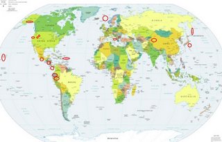
*For Saturday, 19 August 2006.
LEGEND for OVERVIEW: Size = My surety of area for quake.
Red Circle = Probable quake to STRONG quake.
Triangle = Very Strong/Stronger quake (Usually takes extra days).
Blue Circle, etc. = Uncertainty of symptom area for probable quake.

Places to watch.
Good luck to all.
For Saturday, 19 August 2006.
----------------------------------------
The Geysers
(Strong)
----------------------------------------
2.1 2006/08/19 06:46:08 38.815 -122.816 3.5 2 km ( 1 mi) NNW of The Geysers, CA
1.4 2006/08/19 12:43:23 38.797 -122.766 2.3 4 km ( 2 mi) E of The Geysers, CA
2.2 2006/08/19 14:11:41 38.809 -122.793 0.3 2 km ( 1 mi) NE of The Geysers, CA
1.7 2006/08/19 21:11:23 38.780 -122.761 0.0 4 km ( 3 mi) ESE of The Geysers, CA
Southern Alaska/Alaska Peninsula
(Medium)
----------------------------------------
3.5 2006/08/19 14:28:38 55.597 -157.227 1.0 ALASKA PENINSULA
3.9 2006/08/20 00:13:41 61.600 -148.386 120.0 SOUTHERN ALASKA
2.9 2006/08/20 00:57:42 60.313 -153.026 140.0 SOUTHERN ALASKA
Panama Canal area
(medium)
----------------------------------------
(Came in on the 20th and posted there)
Sicily, Italy/Ionian Sea/Albania
----------------------------------------
2006-08-19 16:29:10.0 38.58N 14.45E 25 ML3.1 SICILY, ITALY
Puerto Rico/Virgin Islands
----------------------------------------
3.5 2006/08/19 05:56:42 18.018 -67.793 115.2 64 km ( 40 mi) W of Pole Ojea, PR
3.2 2006/08/19 08:29:51 19.017 -64.715 8.5 52 km ( 33 mi) NW of Settlement, British Virgin Islands
2.6 2006/08/19 11:55:12 18.801 -64.249 38.1 11 km ( 7 mi) NE of Settlement, British Virgin Islands
2.9 2006/08/19 13:54:31 19.256 -68.102 10.3 95 km ( 59 mi) NE of Higüey, Dominican Republic
2.9 2006/08/19 16:39:30 18.915 -64.628 32.1 38 km ( 24 mi) WNW of Settlement, British Virgin Islands
4.4 2006/08/19 16:59:24 19.095 -70.358 63.9 17 km ( 11 mi) NNE of Bonao, Dominican Republic
Honshu, Japan (Second day symptom - Strong)
----------------------------------------
(Came in on the 20th and posted there.)
Nicaragua/El Salvador area (Strong)
----------------------------------------
06/08/19 19:55:38 12.23N 86.66W 94.1 2.5MC SO de La Paz Centro/Nagarote
06/08/19 17:10:01 12.45N 87.71W 22.4 2.8MC Frente al Cosigüina
06/08/19 16:34:43 11.80N 87.44W 35.9 3.5MC Frente a Poneloya
06/08/19 05:37:33 10.92N 86.58W 88.3 3.3ML Frente a El Astillero
06/08/19 04:58:35 11.10N 86.51W 83.8 4.2MC Frente a El Astillero
06/08/19 04:58:35 11.03N 86.57W 65.8 4.0ML Frente a El Astillero
06/08/19 02:41:57 11.91N 86.98W 92.1 2.4ML Frente a Puerto Sandino
06/08/19 00:36:07 12.16N 87.98W 1.0 3.1MC Oceano Pacífico de Nicaragua
Xinjiang, China area (38.44N 75.50E)
----------------------------------------
2006-08-19 05:59:56.0 43.52N 86.52E ML5.7 NORTHERN XINJIANG, CHINA
2006-08-21 02:15:31.0 38.87N 80.44E ML3.0 SOUTHERN XINJIANG, CHINA
(2 extra days)
Southern Mexico
----------------------------------------
2006-08-20 00:14:58.8 8.49N 102.74W 33 mb4.7 OFF COAST OF MEXICO
Northern Peru and then Ecuador area
(Various areas)
----------------------------------------
2006-08-20 20:27:41 4.8 14.69S 74.38W 82 Central Peru
(Not Northern and nothing found for Ecuador)
Kamchatka/Kurils (STRONG)
----------------------------------------
2006-08-20 03:01:04.8 49.87N 156.50E 60 mb5.8 KURIL ISLANDS, RUSSIA
2006-08-20 21:41:46.7 43.93N 148.67E 33 Ms3.7 EAST OF KURIL ISLANDS, RUSSIA
Lincoln, MT area (46.824 -112.751)
(Possible swarm - lots of light pinches)
----------------------------------------
1.1 2006/08/19 11:58:03 45.261 -112.548 0.1 8 km(5 mi) NE of Dillon, MT
06/08/19 06:02:17 44.63N 110.34W 2.3 1.2 4.7 mi N of Fishing Bridge
06/08/19 06:27:42 44.63N 110.34W 2.6 1.2 5.1 mi N of Fishing Bridge
Utah (Strong)
----------------------------------------
06/08/19 00:50:37 39.42N 111.22W 7.2 1.5 15.2 mi WNW of Huntington
06/08/19 01:46:26 39.61N 110.39W 1.8 1.5 4.4 mi NNW of Sunnyside
06/08/19 02:16:49 39.62N 110.41W 1.4 1.7 4.7 mi NNW of Sunnyside
06/08/19 04:57:56 39.61N 110.40W 1.7 1.4 4.4 mi NNW of Sunnyside
06/08/19 05:29:50 39.61N 110.39W 1.5 1.6 4.4 mi NNW of Sunnyside
06/08/19 12:23:03 39.61N 110.38W 0.3 1.6 3.9 mi N of Sunnyside
06/08/19 16:20:19 39.62N 110.39W 1.2 1.8 4.7 mi NNW of Sunnyside
06/08/19 22:50:52 39.40N 111.23W 10.2 1.7 14.9 mi W of Huntington
06/08/20 00:07:32 39.61N 110.39W 1.5 1.7 4.3 mi NNW of Sunnyside
06/08/20 02:09:11 39.73N 110.75W 3.2 1.4 6.8 mi NE of Helper
06/08/20 06:26:47 38.85N 112.11W 4.7 1.2 5.7 mi NNW of Richfield
Hawaii (Strong)
----------------------------------------
2.1 2006/08/19 12:50:24 20.159 -155.628 13.5 7 km ( 5 mi) NW of Kukuihaele, HI
1.7 2006/08/19 15:28:59 19.486 -155.887 6.9 2 km ( 1 mi) SE of Captain Cook, HI
3.3 2006/08/19 17:58:50 19.301 -155.391 4.0 14 km ( 9 mi) NE of Pahala, HI
2.2 2006/08/19 19:20:01 19.331 -155.129 8.4 16 km ( 10 mi) S of Fern Forest, HI
1.7 2006/08/19 21:33:05 19.795 -155.194 6.8 10 km ( 6 mi) W of Papaikou, HI
1.8 2006/08/20 14:02:31 20.047 -155.728 11.6 6 km ( 4 mi) WNW of Waimea, HI
2.0 2006/08/20 15:10:38 19.450 -155.292 0.0 6 km ( 4 mi) W of Volcano, HI
Norway Basin (69.16 -2.74)
----------------------------------------
NORWAY BASIN
Origin time Lat Lon Azres Timres Wres Nphase Ntot Nsta Netmag
2006-230:15.53.33.0 68.51 -4.47 15.12 1.74 5.51 3 3 3 2.44
NORWAY BASIN
Origin time Lat Lon Azres Timres Wres Nphase Ntot Nsta Netmag
2006-230:20.59.55.0 62.89 -1.61 13.57 0.99 4.38 6 7 3 2.12
Peace to all.

