*For Wednesday, 22 February 2006.
LEGEND for OVERVIEW:
Size = My surety of area for quake.
Red Circle = Probable quake to STRONG quake.
Triangle = Very Strong or Stronger quake (And usually takes extra days).
Blue Circle, etc. = Uncertainty of symptom area for probable quake.
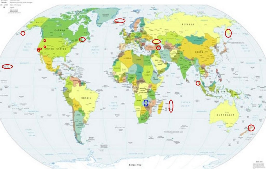
Places to watch.
Good luck to all.
For Wednesday, 22 February 2006.
----------------------------------------
Northern Sumatra (5.42 N 94.51 E) (This was 2 or 3 minutes of bubbling - I expect a swarm. STRONG.)
----------------------------------------
(Nothing found)
Possibly Zambia (Sometimes in early morning hours I write left when I mean right or right when I mean left - if I wrote this right it will be near Zambia but if I wrote it wrong it would be Northwest Russia.)
----------------------------------------
MAP 7.5 2006/02/22 22:19:09 -21.215 33.337 10.0 MOZAMBIQUE
2006-02-23 01:18:06 4.9 20.91S 32.49E Zimbabwe
MAP 5.4 2006/02/23 01:23:42 -21.313 33.385 10.0 MOZAMBIQUE
2006-02-23 02:22:09.5 21.37S 33.59E 33 mb5.3 MOZAMBIQUE
23Feb2006 21:32:12.9 20.6S 33.9E 33 mb=5.2 M GSR MOZAMBIQUE
2006-02-24 23:24:45 5.0 20.99 S 32.90 E Zimbabwe
(This is close but further East than expected. Also a lot stronger than expected. I will have to watch for a repeat of the symptom. This looks like the continuing growth of the Great Rift of Africa.)
New Zealand (-38.190 176.250)
----------------------------------------
Reference Number: 2528738/G
Universal Time: February 20 2006 at 21:45
NZ Daylight Time: Tuesday, February 21 2006 at 10:45 am
Latitude, Longitude: 39.74°S, 176.69°E
Focal Depth: 30 km
Richter Magnitude: 4.0
The Parkfield Fault
----------------------------------------
MAP 1.9 2006/02/22 00:35:25 36.829 -121.562 8.1 3 km ( 2 mi) SW of San Juan Bautista, CA
MAP 1.2 2006/02/22 04:32:25 36.983 -121.697 6.3 8 km ( 5 mi) ENE of Amesti, CA
MAP 2.2 2006/02/22 04:23:22 36.978 -121.698 7.0 8 km ( 5 mi) ENE of Amesti, CA
Central Aleutians and South of (Medium)
----------------------------------------
MAP 3.6 2006/02/22 00:03:37 50.293 179.748 1.0 RAT ISLANDS, ALEUTIAN ISLANDS, ALASKA
MAP 3.2 2006/02/22 02:12:01 51.179 -176.766 1.0 ANDREANOF ISLANDS, ALEUTIAN IS., ALASKA
MAP 2.5 2006/02/22 05:55:50 51.252 -175.644 1.0 ANDREANOF ISLANDS, ALEUTIAN IS., ALASKA
Northwestern Siberia (40.77 N 49.07 E) (2 different symptoms - Strong)
----------------------------------------
2006-02-22 09:24:52 5.5 57.21N 61.30E Ural Mountains Region, Russia
Mammoth Lakes/Tom's Place
----------------------------------------
MAP 1.2 2006/02/22 13:28:50 37.552 -118.773 10.1 8 km ( 5 mi) W of Toms Place, CA
Kamchatka
----------------------------------------
2006-02-24 04:48:14 4.9 54.12N 159.17E Near East Coast of Kamchatka
(2 extra days)
Hawaii (STRONG)
----------------------------------------
MAP 1.9 2006/02/22 00:59:58 19.383 -155.284 2.6 9 km ( 6 mi) SW of Volcano, HI
MAP 2.1 2006/02/22 16:15:56 19.383 -155.235 4.1 7 km ( 5 mi) S of Volcano, HI
Baie-Comeau, QC (49.21N 67.80W)
----------------------------------------
2006/02/22 23:00:06 48.02N 73.79W 18.0g 2.1MN GSC 100 km NW from La Tuque, QC
2006/02/22 12:30:31 49.58N 66.31W 19.1 2.1MN GSC 51 km N from Sainte-Anne-des-Monts, QC
2006/02/22 07:46:42 49.56N 81.56W 18.0g 1.8MN GSC 65 km E from Kapuskasing, ON
2006/02/21 11:13:02 47.78N 70.11W 24.3 1.3MN GSC CHARLEVOIX SEISMIC ZONE, QUE.
2006/02/21 06:35:47 49.43N 65.57W 18.0g 1.2MN GSC 52 km N from Murdochville, QC
Iran/Armenia/Azerbaijan area (39.92N 44.50E) (2 different symptoms - Strong)
----------------------------------------
2006-02-22 11:32:09.1 33.06N 48.78E 15 M3.2 WESTERN IRAN
Mt. St. Helen's
----------------------------------------
MAP 2.2 2006/02/22 15:02:27 46.197 -122.189 0.0 1 km ( 0 mi) WSW of Mount St. Helens Volcano, WA
Iceland/Norwegian Sea area (Medium)
----------------------------------------
NORWEGIAN SEA
Origin time Lat Lon Azres Timres Wres Nphase Ntot Nsta Netmag
2006-054:17.50.36.0 68.59 -7.76 19.10 2.14 6.91 2 3 1 2.51
Mid-Indian Ridge (24.34S 70.27E)
----------------------------------------
2006-02-20 18:52:08 5.0 2.49 S 68.38 E Carlsberg Ridge
2006-02-20 18:55:16.6 2.76S 68.07E 10G M4.5 CARLSBERG RIDGE
(2days early. More North than expected.)
Utah
----------------------------------------
MAP 1.2 2006/02/22 00:57:37 38.060 -112.806 7.6 20 km ( 12 mi) N of Paragonah, UT
MAP 1.6 2006/02/22 03:34:53 39.419 -111.221 5.1 24 km ( 15 mi) WNW of Huntington, UT
MAP 1.5 2006/02/22 05:24:37 39.416 -111.215 6.1 23 km ( 15 mi) WNW of Huntington, UT
MAP 1.7 2006/02/22 05:30:32 39.671 -110.518 1.6 17 km ( 10 mi) NW of Sunnyside, UT
MAP 1.4 2006/02/22 06:04:41 39.413 -111.214 2.3 23 km ( 14 mi) WNW of Huntington, UT
MAP 1.2 2006/02/22 07:47:15 39.666 -110.517 1.8 16 km ( 10 mi) NNW of East Carbon, UT
Peace to all.

posted by Unknown @ 2:45 PM
0 comments
![]()
![]()
