*For Monday, 5 December 2005.
Places to watch.
Good luck to all.
For Monday, 5 December 2005.
----------------------------------------
Galapagos Island area (Medium)
----------------------------------------
2005-12-06 13:00:22 5.1 8.28 S 79.97 W Near Coast of Northern Peru
Parkfield/Pinnacles Fault
----------------------------------------
map 1.1 2005/12/05 02:46:27 35.939 -120.492 6.0 7 km ( 4 mi) NW of Parkfield, CA
map 2.1 2005/12/05 11:18:38 35.885 -120.428 6.3 2 km ( 1 mi) SSE of Parkfield, CA
Labrador/Southern Tip of Greenland area (New symptom) (Medium)
----------------------------------------
(Nothing found)
Honshu, Japan (Medium)
----------------------------------------
MAP 5.5 2005/12/04 22:20:27 37.863 142.429 34.1 OFF THE EAST COAST OF HONSHU, JAPAN
New Madrid Fault/Probably mostly Tennessee (This was all vibrating feet and legs and body but often and deep - VERY STRONG.)
----------------------------------------
(Some came in on the 6th - but this is a lot of symptom for such little movement - may be more coming.)
Mt. Baker area (Possible tiny eruption)
----------------------------------------
map 2.3 2005/12/04 22:51:53 48.867 -122.150 0.5 6 km ( 4 mi) S of Kendall, WA
map 1.1 2005/12/05 05:02:15 48.707N 122.187W 4.1 13 km ( 8 mi) S of Deming, WA
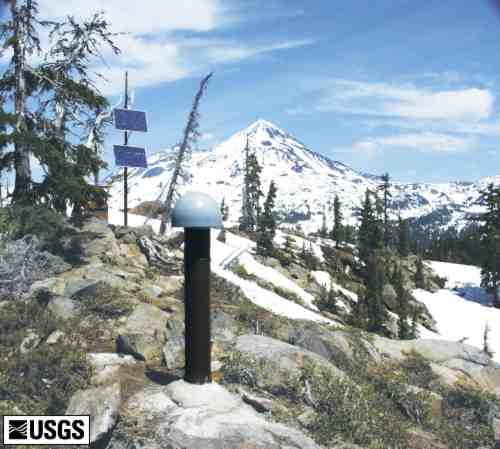
Springfield, Oregon (44.148 -122.898) area/Possibly The Three Sisters Bulge (STRONG)
http://vulcan.wr.usgs.gov/Volcanoes/Cascades/CurrentActivity/2005/current_updates_20050913.html
Three Sisters: USGS scientists from Cascades Volcano Observatory and Menlo Park, California, are completing their fifth annual field campaign in the Three Sisters region of central Oregon, which has been the site of slow uplift of the ground surface since 1997 (see http://vulcan.wr.usgs.gov/Volcanoes/Sisters/framework.html). Ongoing accumulation of a modest volume of magma at a depth of about 3 to 4 miles has caused the ground to rise a maximum of about 1 to 1.5 inch per year over a broad dome-shaped area. This area is about 10 miles in diameter and is centered 3 miles west of South Sister volcano. Annual field work includes sampling of spring waters, repair of seismic and GPS stations, and two types of surveys that measure ground deformation. Work will end on Wednesday and scientists will spend a couple of months making laboratory measurements and analyzing data. Results will be available later in the autumn or early winter. Real-time data from seismic and GPS instruments suggest that there have not been any significant changes over the past year.
West Uplift
----------------------------------------
map 1.2 2005/12/05 02:56:44 45.763N 122.667W 20.8 26 km (16 mi) N of Portland, OR
map 2.0 2005/12/05 13:05:09 44.135N 122.901W 8.5 17 km (11 mi) ENE of Eugene, OR
map 1.9 2005/12/05 14:29:40 43.231N 123.063W 0.0 23 km (14 mi) E of Roseburg, OR
Hawaii (VERY STRONG)
----------------------------------------
map 2.0 2005/12/04 17:03:22 19.337 -155.161 1.6 15 km ( 9 mi) SSE of Volcano, HI
(This was a lot of symptom for 1 quake - I think what came in on the 7th was reflective of this symptom and took 2 extra days which is what happens for STRONG or stronger symptoms.)
MAP 3.4 2005/12/07 08:00:48 18.915 -155.247 13.5 40 km ( 25 mi) ESE of Naalehu, HI
map 2.6 2005/12/07 08:05:50 18.851 -155.211 12.0 46 km ( 29 mi) ESE of Naalehu, HI
MAP 3.0 2005/12/07 08:14:04 18.849 -155.208 8.5 47 km ( 29 mi) ESE of Naalehu, HI
MAP 3.0 2005/12/07 08:40:27 18.834 -155.217 12.0 47 km ( 29 mi) ESE of Naalehu, HI
MAP 3.9 2005/12/07 09:02:07 18.988 -155.268 6.6 33 km ( 20 mi) SE of Pahala, HI
MAP 3.1 2005/12/07 10:11:06 18.988 -155.228 5.1 36 km ( 22 mi) SE of Pahala, HI
MAP 3.5 2005/12/07 11:12:45 18.957 -155.218 11.0 39 km ( 24 mi) SE of Pahala, HI
MAP 3.2 2005/12/07 11:18:58 18.833 -155.206 11.5 48 km ( 30 mi) ESE of Naalehu, HI
MAP 4.5 2005/12/07 11:42:12 18.960 -155.212 0.1 39 km ( 24 mi) SE of Pahala, HI
MAP 3.4 2005/12/07 13:49:22 18.964 -155.208 7.6 39 km ( 24 mi) SE of Pahala, HI
Costa Rica/Panama area (STRONG)
----------------------------------------
05/12/05 23:32:19 12.80N 88.75W 15.0 3.6ML Frente a El Salvador
05/12/05 20:22:00 10.50N 86.05W 1.0 4.0MC Oceano Pacífico de Costa Rica
05/12/05 18:50:01 15.79N 88.36W 13.3 4.6MC Sismo regional o lejano
05/12/05 18:20:17 12.43N 86.47W 2.9 2.1MC Cerca del volcan Momotombo
05/12/05 17:09:54 11.37N 85.45W 10.6 2.3MC Cerca del Volcán Maderas
05/12/05 15:40:39 14.14N 91.75W 5.0 5.6MC Frente a Guatemala
05/12/05 13:34:13 12.38N 86.49W 4.7 2.2MC Cerca del volcan Momotombo
05/12/05 13:23:42 12.35N 86.48W 1.4 3.3MC Cerca del volcan Momotombo
05/12/05 12:20:12 11.38N 85.44W 10.7 2.3MC Cerca del Volcán Maderas
05/12/05 11:28:25 11.48N 85.38W 4.1 2.3MC Nicaragua
05/12/05 11:19:48 11.35N 85.59W 7.8 2.4MC Rivas
05/12/05 05:16:09 11.17N 86.73W 62.2 3.3MC Frente a La Boquita y Casares
05/12/05 03:18:17 12.77N 86.89W 1.0 2.0MC Nicaragua
Poland (STRONG)
----------------------------------------
2005/12/05 00:29:33.2 51.30 N 16.26 E 2 ML2.5 POLAND
2005/12/05 17:12:34.0 51.25 N 15.94 E ML2.2 POLAND
Central Italy
----------------------------------------
2005/12/06 15:40:59.2 46.70 N 10.70 E 16 ML2.0 NORTHERN ITALY 2005/12/06 14:33:37.8 46.70 N 10.60 E 19 ML2.4 NORTHERN ITALY
2005/12/06 14:11:35.0 46.70 N 10.70 E 16 ML2.1 NORTHERN ITALY
2005/12/06 13:13:45.4 46.70 N 10.70 E 16 ML2.3 NORTHERN ITALY
Mariana Islands area (2 different symptoms - Strong)
----------------------------------------
2005/12/04 04:17:23.2 12.13 N 140.72 E 33 mb4.9 WESTERN CAROLINE IS
Northcentral Iran (STRONG)
----------------------------------------
2005/12/04 05:45:23.2 36.19 N 48.81 E 28 M 3.2 NORTHWESTERN IRAN
Jordan/Syria/Cyprus area (I posted for this area for the 3d - that was a precursor - this will be EXTREMELY STRONG.)
Rock Tombs in Petra, Jordan

----------------------------------------
(This must still be coming - making it a really dangerous quake.)
Finland/Norway/Sweden (Same tiny bubbles and crawls for this area - nothing even medium)
----------------------------------------
NORWAY BASIN
Origin time Lat Lon Azres Timres Wres Nphase Ntot Nsta Netmag
2005-336:17.29.22.0 67.11 -4.72 8.90 5.14 7.37 3 3 2 2.18
NORWEGIAN SEA
Origin time Lat Lon Azres Timres Wres Nphase Ntot Nsta Netmag
2005-336:21.04.55.0 68.38 -6.41 0.68 3.07 3.24 2 3 1 2.06
Peace to all.

posted by Unknown @ 10:47 AM
0 comments
![]()
![]()
