*For Sunday, 21 January 2007.
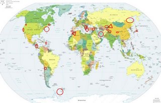
LEGEND for OVERVIEW: Size = My surety of area for quake.
Red Circle = Probable quake to STRONG quake.
Triangle = Very Strong/Stronger quake (Usually takes extra days).
Blue Circle, etc. = Uncertainty of symptom area for probable quake.

Places to watch.
Good luck to all.
For Sunday, 21 January 2007.
--------------------------------------
The Parkfield Fault/Central
--------------------------------------
1.0 2007/01/21 07:03:39 36.863 -121.595 4.6 5 km ( 3 mi) ESE of Aromas, CA
1.3 2007/01/21 17:12:18 36.020 -120.589 3.2 19 km ( 12 mi) NW of Parkfield, CA
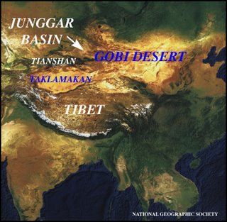
Xinjiang, China area (43.63N 83.85E)
(Very Strong)
www.gwu.edu

--------------------------------------
2007-01-20 17:51:18.5 31.27N 82.70E 86 mb3.8 WESTERN XIZANG
(Not as far North as expected and not very strong.)
Scotia Sea (60.54S 49.52W)(Strong)
--------------------------------------
2007-01-21 15:03:14.8 55.75S 26.98W 32 M5.7 SOUTH SANDWICH ISLANDS REGION
2007-01-23 22:46:22.9 55.13S 29.27W 33 mb5.3 SOUTH SANDWICH ISLANDS REGION
Morocco/Algeria area (4.93N 3.95W)
(Very Strong)
(Wonderful tour of Morocco -
Thank you, Mr. Trumbull)
www.be.wvu.edu

--------------------------------------
(Nothing found)
EASTERN TURKEY (38.79N 40.05E)
then Aegean Sea area
(38.23N 26.75E)
--------------------------------------
2007-01-21 07:39:01.3 39.70N 42.91E 30 mb5.0 EASTERN TURKEY
2007-01-21 11:24:52.3 39.57N 42.77E 3 MD3.1 EASTERN TURKEY
2007-01-21 12:08:19.5 39.61N 42.90E 8 ML3.6 EASTERN TURKEY
2007-01-21 14:52:08.0 39.61N 24.46E ML3.3 AEGEAN SEA
2007-01-21 15:33:59.2 39.58N 42.82E 5 MD3.4 EASTERN TURKEY
2007-01-21 19:32:08.9 39.61N 42.83E 4 MD3.3 EASTERN TURKEY
Nicaragua/Costa Rica
--------------------------------------
07/01/21 23:06:44 11.79N 87.13W 1.0 1.8ML Frente a Puerto Sandino
07/01/21 19:43:21 11.71N 87.79W 3.0 3.0ML Oceano Pacífico de Nicaragua
07/01/21 19:33:05 11.91N 87.63W 60.4 3.4ML Frente a Corinto
07/01/21 17:19:19 12.35N 86.56W 3.4 1.1ML Cerca del volcan Momotombo
07/01/21 15:31:28 12.58N 88.11W 18.6 3.2MC Frente al Golfo de Fonseca
07/01/21 11:52:18 12.60N 86.53W 71.2 1.7ML Nicaragua
07/01/21 09:03:39 11.58N 87.07W 12.2 3.8ML Frente a Masachapa
07/01/21 07:52:24 11.11N 86.48W 5.0 2.3ML Frente a El Astillero
07/01/21 03:46:52 12.18N 87.16W 99.0 2.5MC Frente a Poneloya
Iran (Strong)
--------------------------------------
2007-01-21 13:53:28.0 36.25N 59.18E M3.5 NORTHEASTERN IRAN
2007-01-21 16:01:32.7 35.27N 58.52E 4 M3.0 NORTHEASTERN IRAN
Kyrgyzstan/Kazakhstan area
--------------------------------------
2007-01-21 10:51:28.0 45.50N 54.54E ML3.5 WESTERN KAZAKHSTAN
Tajikistan (37.83N 73.89E)
(Third day symptom - STRONG)
--------------------------------------
(Posted on the 20th and 22nd.)
CHARLEVOIX SEISMIC ZONE, QUE.
(47.75N 69.73W)
--------------------------------------
2007/01/22 03:06:19 47.51N 70.02W 12.0 1.3MN CHARLEVOIX SEISMIC ZONE,QC.
Honshu, Japan
--------------------------------------
(Nothing found)
Tierras Nuevas Poniente, PR
(19.101N -66.458W)
--------------------------------------
2007/01/21 04:10:10.53 19.173N 64.891W 22.0 3.4 D Sombrero Fault Zone
2007/01/21 05:48:10.78 18.539N 68.719W 15.0 3.8 D Eastern Dominican Republic
2007/01/21 07:24:22.90 18.161N 64.009W 131.7 3.8 C Leeward Islands
2007/01/21 09:24:48.49 19.085N 64.914W 6.3 3.3 C Sombrero Fault Zone
2007/01/21 15:42:39.36 19.023N 64.789W 80.7 3.2 C Sombrero Fault Zone
2007/01/21 15:44:12.04 19.040N 65.778W 5.9 2.8 D 19° N Fault Zone
2007/01/21 20:32:12.76 19.197N 64.863W 59.7 3.5 C Sombrero Fault Zone
2007/01/21 20:43:08.66 19.435N 64.980W 6.7 3.1 D Puerto Rico Trench
2007/01/21 20:44:22.27 19.538N 64.932W 8.5 2.7 C Puerto Rico Trench
2007/01/21 23:26:30.36 19.377N 64.818W 47.5 3.4 C Sombrero Fault Zone
Strait of Gibraltar
--------------------------------------
(Nothing found)
Sea of Okhotsk to
Southeastern Siberia
--------------------------------------
(Nothing found)
NORTHWESTERN BALKAN PEN.
(41.30N 22.60E)
--------------------------------------
(Nothing found)
Hindu Kush, Afghanistan
(35.35N 69.72E) (STRONG)
--------------------------------------
(Nothing found)
Mt. St. Helen’s
--------------------------------------
1.6 2007/01/20 08:35:36 46.195 -122.195 0.8 1 km ( 1 mi) WSW of Mount St. Helens Volcano, WA
1.6 2007/01/20 16:05:06 46.195 -122.190 1.4 1 km ( 1 mi) SW of Mount St. Helens Volcano, WA
1.6 2007/01/20 21:09:49 46.194 -122.189 0.0 1 km ( 1 mi) SW of Mount St. Helens Volcano, WA
2.1 2007/01/21 01:08:27 46.196 -122.198 3.0 1 km ( 1 mi) WSW of Mount St. Helens Volcano, WA
1.9 2007/01/21 04:29:44 46.196 -122.187 0.0 1 km ( 0 mi) SW of Mount St. Helens Volcano, WA
1.7 2007/01/21 13:41:30 46.197 -122.199 0.0 2 km ( 1 mi) WSW of Mount St. Helens Volcano, WA
Chile/Argentina border area
(24.26S 67.00W) (Strong)
--------------------------------------
2007-01-23 20:40:15 5.0mb 45.22S 71.64W 10 S. Chile-Argentina Border Region
(Off on co-ordinates some)
QINGHAI, CHINA (33.76N 91.24E)
(Strong)
--------------------------------------
(Nothing found)
Hamburg, NJ area (41.160 -74.535)
--------------------------------------
2.4 2007/01/20 17:20:00 42.637 -78.796 8.0 5 km ( 3 mi) S of North Boston, NY
Peace to all.

