*For Monday, 27 February 2006.
LEGEND for OVERVIEW:
Size = My surety of area for quake.
Red Circle = Probable quake to STRONG quake.
Triangle = Very Strong or Stronger quake (And usually takes extra days).
Blue Circle, etc. = Uncertainty of symptom area for probable quake.
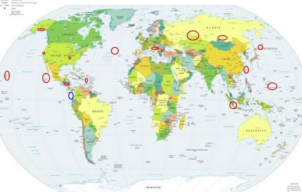
Places to watch.
Good luck to all.
For Monday, 27 February 2006.
----------------------------------------
Hawaii
----------------------------------------
MAP 2.8 2006/02/27 01:37:15 19.322 -155.053 44.2 19 km ( 12 mi) SSE of Fern Forest, HI
MAP 2.3 2006/02/27 07:10:45 19.426 -155.318 7.4 9 km ( 6 mi) WSW of Volcano, HI
MAP 2.6 2006/02/27 07:09:01 19.388 -155.281 3.0 8 km ( 5 mi) SW of Volcano, HI
MAP 2.0 2006/02/27 17:38:36 19.769 -155.869 11.6 15 km ( 9 mi) ENE of Kalaoa, HI
MAP 1.7 2006/02/27 22:09:13 19.237 -155.593 0.0 13 km ( 8 mi) WNW of Pahala, HI
The Geysers (strong)
----------------------------------------
MAP 1.9 2006/02/27 13:54:18 38.828 -122.879 2.4 7 km ( 4 mi) WNW of The Geysers, CA
MAP 1.5 2006/02/27 16:19:12 38.796 -122.761 2.1 4 km ( 2 mi) E of The Geysers, CA
Southern Alaska
----------------------------------------
MAP 3.3 2006/02/26 08:47:29 59.450 -152.969 19.9 SOUTHERN ALASKA
MAP 2.7 2006/02/27 16:50:57 60.084 -152.622 100.0 SOUTHERN ALASKA
Central Italy/Adriatic Sea/Bosnia area (STRONG)
----------------------------------------
2006-02-27 04:34:01.3 38.12N 15.24E 10 ML4.5 SICILY, ITALY
2006-02-27 07:30:55.0 38.13N 15.19E 9 ML2.8 SICILY, ITALY
2006-02-27 15:55:39.0 38.14N 15.17E 6 ML3.0 SICILY, ITALY
2006-02-27 14:16:06.0 38.14N 15.18E 7 ML3.3 SICILY, ITALY
2006-02-27 13:52:11.0 38.14N 15.18E 8 ML2.8 SICILY, ITALY
2006-02-27 09:15:00.0 38.13N 15.18E 9 ML2.6 SICILY, ITALY
2006-02-27 09:11:59.0 38.14N 15.18E 8 ML3.5 SICILY, ITALY
(Not central)
Guatamala/El Salvador area then possibly Ecuador
----------------------------------------
06/02/27 22:01:36 12.42N 87.74W 12.6 4.1ML Frente al Cosigüina
06/02/27 11:26:00 11.39N 85.41W 5.1 2.5ML Cerca del Volcán Maderas
06/02/27 10:01:51 12.95N 87.67W 1.0 3.2MC Cerca del volcan Cosigüina
06/02/27 05:13:25 11.84N 87.31W 12.7 2.5MC Frente a Poneloya
06/02/27 05:08:34 10.76N 86.90W 5.7 3.4MC Frente a El Astillero
06/02/27 03:58:38 12.56N 88.16W 10.8 3.1MC Frente al Golfo de Fonseca
06/02/27 03:05:12 13.32N 87.62W 191.1 3.3MC Golfo de Fonseca
06/02/27 02:41:05 12.39N 86.53W 5.8 2.0MC Cerca del volcan Momotombo
06/02/27 01:57:28 12.39N 86.53W 6.0 2.5MC Cerca del volcan Momotombo
Central/North Atlantic/Above Azores area
----------------------------------------
2006-02-26 09:08:24.3 50.09N 29.10W 10f mb4.5 NORTHERN MID-ATLANTIC RIDGE
New Madrid Fault/North of Caruthersville, Missouri (36.220N 89.610W)
----------------------------------------
MAP 1.9 2006/02/27 10:09:16 35.350 -84.520 10.1 2 km ( 1 mi) NNE of Etowah, TN
MAP 1.5 2006/02/27 12:45:51 36.540 -89.610 7.6 3 km ( 2 mi) N of Marston, MO
Mariana Islands area (Second day symptom - STRONG)
----------------------------------------
2006-02-25 14:49:40 5.6 12.27N 141.18E South of Mariana Islands
(2 posted on 26th posting - this quake was upgraded from a 4.8 to a 5.6magnitude.)
Puerto Rico
----------------------------------------
MAP 3.6 2006/02/27 02:08:45 19.471 -68.882 47.1 55 km ( 34 mi) ENE of Samaná, Dominican Republic
MAP 3.2 2006/02/27 21:32:34 18.754N -67.401W 16.0 43 km (27 mi) NW of San Antonio, PR
MAP 3.5 2006/02/27 19:06:41 17.452N -68.299W 118.2 130 km (81 mi) SSE of La Romana, La Romana, Dominican Republic
map 2.8 2006/02/27 06:15:08 18.221N -67.197W 87.1 6 km ( 4 mi) WNW of Mayagüez, PR
MAP 3.0 2006/02/27 00:09:12 18.231N -67.194W 123.8 6 km ( 4 mi) S of La Playa, PR
MAP 3.2 2006/02/28 21:35:28 18.135N -64.249W 5.0 30 km (19 mi) SSW of West End, Tortola, British Virgin Islands
MAP 3.4 2006/02/28 11:14:01 18.040N -67.915W 72.6 77 km (48 mi) W of Puerto Real, PR
map 2.6 2006/02/28 10:12:40 18.507N -66.266W 119.8 5 km ( 3 mi) N of Dorado, PR
map 0.7 2006/02/28 09:23:04 18.094N -65.841W 2.6 1 km ( 1 mi) NNE of Comunas, PR
map 2.8 2006/02/28 08:25:27 19.113N -67.121W 10.0 69 km (43 mi) N of San Antonio, PR
MAP 3.2 2006/02/28 07:12:13 19.084N -67.144W 10.0 66 km (41 mi) N of San Antonio, PR
map 2.8 2006/02/28 02:11:18 18.466N -66.082W 108.8 7 km ( 4 mi) NNW of San Juan, PR
Taiwan to Ryukyu, Japan (Strong)
----------------------------------------
2006-02-27 09:10:54.0 26.82N 127.68E 33 mb5.2 RYUKYU ISLANDS, JAPAN
(Also posted on the 26th)
Kuril Islands (STRONG)
----------------------------------------
(Nothing found)
North Kazakhstan into Russia then Lake Baykal,Russia (55.55N110.54E) (STRONG for both areas)
----------------------------------------
NORTHWESTERN SIBERIA, RUSSIA
Origin time Lat Lon Azres Timres Wres Nphase Ntot Nsta Netmag
2006-057:19.48.18.0 62.75 67.92 10.75 0.14 2.83 2 2 1 3.10
NORTHWESTERN SIBERIA, RUSSIA
Origin time Lat Lon Azres Timres Wres Nphase Ntot Nsta Netmag
2006-058:11.41.13.0 70.04 74.12 11.40 0.08 2.93 2 2 1 2.86
(Nothing for Lake Baykal)
Southern Sumatra (2 different symptoms - STRONG)
----------------------------------------
27Feb2006 17:05:10.7 2.9N 93.9E 33 mb=5.1 M*GSR OFF W COAST OF NORTHERN SU
(Not Southern)
Revillagigedo Islands/Off the Coast of Mexico (STRONG)
----------------------------------------
15(F) 2006/02/27 13:39:02 15.46 93.32 90 4.4 COSTA DE CHIAPAS
16(G) 2006/02/27 19:36:39 16.82 100.22 5 3.7 COSTA DE GUERRERO
(More south than expected.)
Peace to all.

posted by Unknown @ 1:18 PM
0 comments
![]()
![]()
