*For Monday, 3 April 2006.
LEGEND for OVERVIEW: Size = My surety of area for quake.
Red Circle = Probable quake to STRONG quake.
Triangle = Very Strong or Stronger quake (And usually takes extra days).
Blue Circle, etc. = Uncertainty of symptom area for probable quake.
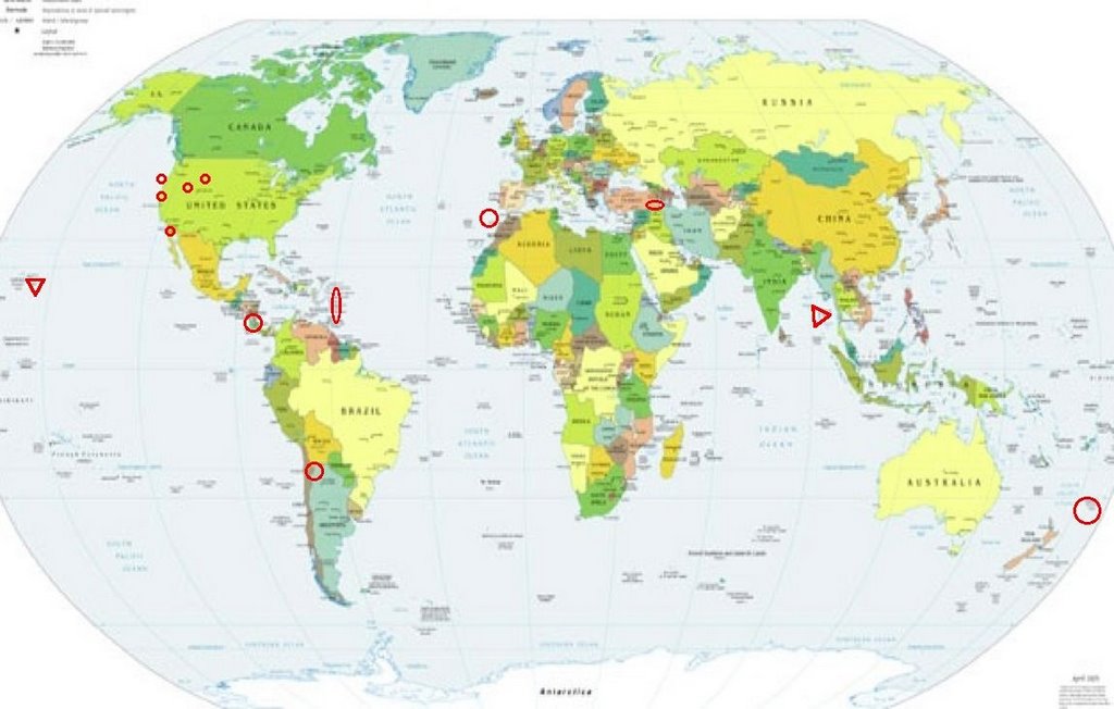
Places to watch.
Good luck to all.
For Monday, 3 April 2006.
----------------------------------------
Kermadec Islands
----------------------------------------
2006-04-01 03:40:53.9 29.53 S 177.48 W 65 f mb 4.7 KERMADEC ISLANDS, NEW ZEALAND
2006-04-01 05:15:34.5 29.65 S 177.28 W 51 mb 5.4 KERMADEC ISLANDS, NEW ZEALAND
2006-04-01 06:25:43.0 29.27 S 177.26 W 43 mb 5.3 KERMADEC ISLANDS, NEW ZEALAND
2006-04-01 08:19:16.8 29.34 S 177.20 W 72 M 5.1 KERMADEC ISLANDS, NEW ZEALAND
2006-04-01 10:32:25 5.1 29.22 S 177.80 W Kermadec Islands, New Zealand
2006-04-01 11:30:22 5.3 30.26 S 178.25 W Kermadec Islands, New Zealand
2006-04-01 17:51:07 5.3 29.67 S 176.87 W Kermadec Islands Region
01Apr2006 17:55:59.6 29.7S 176.9W 33 MS=5.2 M*GSR KERMADEC ISLANDS REGION
01Apr2006 20:02:40.2 29.5S 177.6W230 mb=5.2 M GSR KERMADEC ISLANDS, NEW ZEAL
(2 days early)
2006-04-03 01:41:26.1 28.77 S 177.76 W 100 f mb 5.1 KERMADEC ISLANDS REGION
2006-04-04 10:47:15.0 29.01 S 177.09 W 10 f mb 5.1 KERMADEC ISLANDS, NEW ZEALAND
04Apr2006 16:10:12.2 29.0S 177.3W 33 mb=5.2 M GSR KERMADEC ISLANDS, NEW ZEAL
04Apr2006 20:15:52.8 29.8S 177.1W 33 MS=5.1 M*GSR KERMADEC ISLANDS, NEW ZEAL
04Apr2006 23:57:26.4 29.6S 177.2W 33 mb=5.5 M*GSR KERMADEC ISLANDS, NEW ZEAL
05Apr2006 00:27:34.0 29.8S 177.1W 33 mb=5.7 M GSR KERMADEC ISLANDS, NEW ZEAL
(2 extra days)
North Atlantic/Strait of Gibraltar area (35.47N 13.07W) (STRONG)
----------------------------------------
02Apr2006 06:44:46.6 35.6N 4.3E110 mb=4.7 M*GSR NORTHERN ALGERIA
2006-04-02 19:41:57.0 35.95 N 3.98 W 12 mb 3.0 STRAIT OF GIBRALTAR
Utah/Nevada
----------------------------------------
MAP 1.4 2006/04/02 01:36:10 39.723 -110.747 1.3 10 km ( 6 mi) ENE of Helper, UT
MAP 1.7 2006/04/02 03:48:09 39.608 -110.395 1.0 6 km ( 4 mi) N of Sunnyside, UT
MAP 1.6 2006/04/02 04:54:34 39.607 -110.391 0.7 6 km ( 4 mi) N of Sunnyside, UT
MAP 1.0 2006/04/02 05:32:46 37.412 -117.078 4.6 20 km ( 13 mi) NE of Tokop, NV
MAP 1.5 2006/04/02 05:51:09 39.670 -110.513 1.8 16 km ( 10 mi) NW of Sunnyside, UT
MAP 1.6 2006/04/02 07:00:39 41.147 -112.804 4.4 57 km ( 36 mi) W of Hooper, UT
MAP 1.9 2006/04/02 07:09:36 39.967 -111.582 9.3 8 km ( 5 mi) SE of Woodland Hills, UT
MAP 1.5 2006/04/02 08:23:32 39.701 -110.724 0.9 12 km ( 7 mi) E of Helper, UT
MAP 1.2 2006/04/02 13:13:23 37.419 -117.083 5.7 20 km ( 13 mi) NE of Tokop, NV
MAP 1.2 2006/04/02 14:15:51 37.415 -117.080 0.0 20 km ( 13 mi) NE of Tokop, NV
MAP 1.6 2006/04/02 19:03:37 39.740 -110.726 0.2 13 km ( 8 mi) ENE of Helper, UT
MAP 1.5 2006/04/02 20:45:21 38.986 -111.327 7.0 10 km ( 6 mi) NW of Emery, UT
MAP 1.1 2006/04/02 21:31:53 39.726 -110.747 1.4 10 km ( 6 mi) ENE of Helper, UT
MAP 1.4 2006/04/03 04:37:56 39.608 -110.392 0.8 6 km ( 4 mi) N of Sunnyside, UT
MAP 1.4 2006/04/03 14:40:55 39.413 -111.216 5.0 23 km ( 15 mi) WNW of Huntington, UT
MAP 1.5 2006/04/03 16:55:57 41.344 -112.003 1.8 3 km ( 2 mi) N of Pleasant View, UT
MAP 1.5 2006/04/03 17:20:00 39.411 -111.207 5.8 23 km ( 14 mi) WNW of Huntington, UT
MAP 1.9 2006/04/03 22:16:42 41.153 -112.668 14.5 46 km ( 29 mi) W of Hooper, UT
MAP 1.9 2006/04/03 22:49:52 39.490 -119.624 0.0 12 km ( 7 mi) SE of Sparks, NV
MAP 1.5 2006/04/03 23:06:56 39.672 -110.514 1.6 16 km ( 10 mi) NW of Sunnyside, UT
MAP 1.0 2006/04/04 21:48:13 39.726 -119.497 12.3 16 km ( 10 mi) SW of Nixon, NV
MAP 1.6 2006/04/04 21:38:25 39.611 -110.394 0.9 7 km ( 4 mi) N of Sunnyside, UT
MAP 1.5 2006/04/04 18:34:14 39.608 -110.396 0.9 6 km ( 4 mi) N of Sunnyside, UT
MAP 2.0 2006/04/04 18:19:01 39.732 -110.805 0.3 7 km ( 4 mi) NE of Helper, UT
MAP 1.9 2006/04/04 17:22:47 38.989 -111.338 9.7 11 km ( 7 mi) NW of Emery, UT
MAP 1.4 2006/04/04 17:21:56 39.669 -110.512 2.1 16 km ( 10 mi) NW of Sunnyside, UT
MAP 1.6 2006/04/04 14:07:41 39.672 -110.513 1.7 16 km ( 10 mi) NW of Sunnyside, UT
MAP 1.5 2006/04/04 05:48:37 39.673 -110.522 0.8 17 km ( 11 mi) NNW of East Carbon, UT
MAP 1.3 2006/04/04 02:11:02 36.716 -116.303 5.0 46 km ( 28 mi) ESE of Beatty, NV
MAP 1.4 2006/04/04 01:13:31 39.704 -110.591 1.2 22 km ( 14 mi) ENE of Price, UT
MAP 1.3 2006/04/04 00:41:38 39.609 -110.394 1.1 6 km ( 4 mi) N of Sunnyside, UT
Madison Junction, Wyoming area (44.600N 110.738W)
----------------------------------------
MAP 2.1 2006/04/03 16:46:41 45.373 -112.601 6.2 18 km ( 11 mi) N of Dillon, MT
MAP 1.3 2006/04/03 19:14:15 45.350 -112.574 0.6 16 km ( 10 mi) NNE of Dillon, MT
MAP 1.1 2006/04/04 11:03:49 45.171 -112.627 0.6 5 km ( 3 mi) S of Dillon, MT
(Wyoming came in on the 4th - this part of the symptom is for Montana, I think.)
Costa Rica area (9.85 N 84.30 W).
----------------------------------------
06/04/04 07:48:35 10.82N 85.94W 54.2 2.3MC Frente a San Juan del Sur
06/04/04 22:11:20 11.70N 86.74W 52.3 2.6MC Frente a Masachapa
Petrolia and North of (Medium)
----------------------------------------
(Nothing found)
The Virgin Islands (STRONG)
----------------------------------------
MAP 2.9 2006/04/03 02:40:41 19.112 -67.836 5.2 104 km ( 65 mi) NW of Aguadilla, PR
MAP 1.8 2006/04/03 06:10:49 17.960 -66.566 17.7 7 km ( 4 mi) SSW of Capitanejo, PR
MAP 3.4 2006/04/03 06:49:41 19.486 -64.857 24.9 101 km ( 63 mi) NW of Settlement, British Virgin Islands
MAP 3.4 2006/04/03 07:45:29 17.046 -68.596 25.3 159 km ( 99 mi) SSE of La Romana, Dominican Republic
MAP 3.2 2006/04/03 08:18:01 19.082 -65.701 131.8 74 km ( 46 mi) NNE of Suárez, PR
MAP 2.3 2006/04/03 10:46:52 18.082 -64.522 2.9 41 km ( 25 mi) SE of Cruz Bay, US Virgin Islands
MAP 2.6 2006/04/03 16:20:20 18.894 -63.700 6.2 68 km ( 42 mi) ENE of Settlement, British Virgin Islands
MAP 2.9 2006/04/03 16:59:51 18.405 -64.222 14.6 4 km ( 3 mi) W of West End, British Virgin Islands
MAP 2.8 2006/04/03 17:36:45 19.076 -65.381 19.0 86 km ( 53 mi) NNE of Luquillo, PR
MAP 2.9 2006/04/03 17:32:51 19.289 -65.365 50.3 108 km ( 67 mi) NNE of Vieques, PR
MAP 2.9 2006/04/03 17:31:48 19.037 -65.381 16.5 82 km ( 51 mi) N of Culebra, PR
MAP 2.9 2006/04/03 17:29:28 18.968 -65.391 32.7 74 km ( 46 mi) N of Culebra, PR
MAP 3.1 2006/04/03 17:27:52 19.038 -65.371 13.4 82 km ( 51 mi) N of Culebra, PR
MAP 2.6 2006/04/03 17:25:38 19.046 -65.326 6.7 82 km ( 51 mi) N of Culebra, PR
MAP 2.9 2006/04/03 18:31:35 19.057 -65.341 11.1 84 km ( 52 mi) N of Culebra, PR
MAP 3.1 2006/04/03 18:29:02 19.094 -65.296 3.2 88 km ( 54 mi) N of Culebra, PR
MAP 3.7 2006/04/03 18:25:36 19.047 -65.360 18.3 83 km ( 51 mi) N of Culebra, PR
NNE of Kukuihaele, HI area (20.329 -155.465) (VERY STRONG)
http://starbulletin.com/2006/03/25/news/story04.html>starbulletin
----------------------------------------
MAP 2.2 2006/04/02 04:21:28 19.399 -155.281 2.7 7 km ( 5 mi) SW of Volcano, HI
MAP 2.1 2006/04/02 07:03:37 19.438 -155.637 3.0 26 km ( 16 mi) E of Honaunau-Napoopoo, HI
MAP 2.1 2006/04/03 05:43:18 19.344 -155.318 2.0 15 km ( 9 mi) SW of Volcano, HI
Point Arena, California
----------------------------------------
(Nothing found)
Turkey/Iraq border area
----------------------------------------
2006-04-03 11:25:03.7 37.17 N 34.36 E 29 MD 2.9 TURKEY
2006-04-03 12:36:43.6 37.00 N 27.77 E 30 MD 2.9 TURKEY
2006-04-04 15:49:29.9 38.75 N 31.20 E 10 MD 2.9 TURKEY
2006-04-04 19:08:12.8 37.72 N 43.80 E 8 MD 3.2 TURKEY
2006-04-04 21:29:22.4 39.00 N 31.77 E 22 MD 2.8 TURKEY
2006-04-04 21:21:52.3 39.58 N 38.02 E 24 MD 3.3 TURKEY
2006-04-04 20:21:09.2 38.65 N 39.33 E 32 MD 3.0 TURKEY
Andaman Islands (11.54 N 95.10 E) (Very Strong)
http://volcano.und.nodak.edu/vwdocs/current_volcs/barren_isle/Barren_Isle.html>volcano.und.nodak

----------------------------------------
(Nothing found)
Guadalupe Victoria, Mexico area (32.355N 115.252W)
----------------------------------------
MAP 3.5 2006/04/02 03:25:05 31.773 -114.896 3.8 61 km ( 38 mi) SSE of Guadalupe Victoria, Mexico
MAP 2.0 2006/04/03 05:29:04 32.334 -115.021 6.0 10 km ( 6 mi) ENE of Guadalupe Victoria, Mexico
MAP 2.5 2006/04/04 06:31:35 32.333 -115.212 34.8 11 km ( 7 mi) WNW of Guadalupe Victoria, Mexico
MAP 2.5 2006/04/04 06:23:23 31.810 -115.916 0.4 47 km ( 29 mi) NNW of Lázaro Cárdenas, Mexico
MAP 1.9 2006/04/04 07:55:10 32.699 -115.385 5.0 9 km ( 6 mi) NE of Mexicali, Mexico
Chile/Argentina border area (24.26S 67.00W) (Strong)
----------------------------------------
2006-04-04 05:47:30.4 22.95 S 66.42 W 165 mb 4.7 JUJUY PROVINCE, ARGENTINA
(Posted on 2 April also - 2 different symptoms for same area - more may be coming.)
2006-04-05 01:34:12 5.0 31.94 S 70.39 W Chile-Argentina Border Region
(2 extra days)
Peace to all.

posted by Unknown @ 1:02 PM
0 comments
![]()
![]()
