*For Monday, 7 August 2006.
LEGEND for OVERVIEW: Size = My surety of area for quake.
Red Circle = Probable quake to STRONG quake.
Triangle = Very Strong/Stronger quake (Usually takes extra days).
Blue Circle, etc. = Uncertainty of symptom area for probable quake.
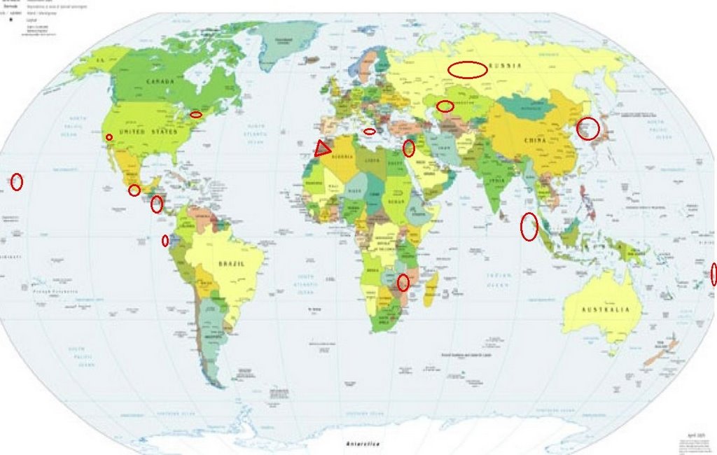
Places to watch.
Good luck to all.
For Monday, 7 August 2006.
----------------------------------------
Huntington, Quebec area (45.00N 74.42W)
(Strong-felt volcanic)
----------------------------------------
2006/08/08 03:09:44 47.69N 70.01W 19.4 2.8MN Felt 12 km NE from La Malbaie,QC.
(Posted on 6th also - 2 different symptoms - same general area.)
Mozambique area
----------------------------------------
(Nothing found)
North Korea to Sea of Japan area (Medium)
----------------------------------------
(Nothing found)
Off the Coast of Ecuador (1.55S 81.05W)
(Second day symptom - Strong)
----------------------------------------
4.4 2006/08/06 14:18 2006/08/06 19:18 -4.0775 -79.8631 12.00
4.7 2006/08/06 00:33 2006/08/06 05:33 -3.0664 -80.4514 12.00
Northern Sumatra (2.3N 97.6E)
(Second day symptom but already at
Strong - STRONG)
----------------------------------------
2006-08-07 18:29:26 4.6 1.54N 97.30E 20 km Northern Sumatra, Indonesia
Coso Junction
----------------------------------------
(Nothing found)
Morocco area (Still getting symptoms.)
----------------------------------------
2006-08-07 10:59:45.0 34.91N 3.88E 10f mb4.8 NORTHERN ALGERIA
WESTERN KAZAKHSTAN
----------------------------------------
2006-08-07 18:04:49.0 50.66N 65.73E ML3.1 CENTRAL KAZAKHSTAN
Sicily, Italy/Ionian Sea
----------------------------------------
2006-08-06 01:07:53.0 40.59N 15.75E 10 ML 2.8 SOUTHERN ITALY
2006-08-06 13:02:01.0 37.74N 14.93E 21 ML 2.6 SICILY, ITALY
2006-08-06 19:33:32.9 41.87N 15.47E 40 ML 3.8 SOUTHERN ITALY
Ural Mountains, Russia area
(57.21N 61.30E)
----------------------------------------
(Nothing found - I’m beginning to question this symptom area.)
Hawaii
----------------------------------------
2.1 2006/08/07 00:28:48 19.432 -155.626 2.7 27 km(17 mi) E of Honaunau-Napoopoo, HI
3.1 2006/08/07 01:19:27 19.389 -155.246 2.9 7 km ( 4 mi) S of Volcano, HI
2.1 2006/08/07 01:21:26 19.383 -155.240 3.5 7 km ( 5 mi) S of Volcano, HI
1.7 2006/08/07 07:52:23 19.055 -155.381 32.8 20 km ( 12 mi) SSE of Pahala, HI
2.4 2006/08/07 10:09:05 19.070 -155.377 36.3 18 km ( 11 mi) SE of Pahala, HI
Southern Mexico Coast
----------------------------------------
2006/08/07 02:51:34 16.81 100.15 12 3.3 23 km al SUROESTE de COYUCA DE BENITEZ, GRO
2006/08/07 17:27:35 17.90 99.58 5 3.4 28 km al NORTE de ZUMPANGO DEL RIO, GRO
2006/08/08 00:44:43 16.91 94.64 170 4.0 43 km al ESTE de MATIAS ROMERO, OAX
2006/08/08 11:46:24 14.56 94.06 12 4.3 155 km al SUROESTE de PIJIJIAPAN, CHIS
2006/08/08 17:46:45 17.94 99.55 5 3.7 32 km al NORTE de ZUMPANGO DEL RIO, GRO
2006/08/08 17:52:41 17.31 100.70 50 3.7 12 km al NOROESTE de TECPAN, GRO
Syria/Jordan area (34.64N 36.00E)
----------------------------------------
2006-08-10 18:16:32.0 35.21N 39.31E 10 ML3.9 JORDAN - SYRIA REGION
(3 extra days)
Samoa Region (15.33S 172.81W)
(STRONG)
----------------------------------------
2006-08-06 20:53:28 5.5 4.02S 171.43W 20 km Phoenix Islands, Kiribati Region
OFFSHORE EL SALVADOR (12.580 -89.237)
(Indication of depth - STRONG)
----------------------------------------
06/08/06 23:28:60 12.34N 88.11W 1.0 3.0ML Frente al Cosigüina
06/08/08 06:25:22 13.06N 89.51W 30.0 3.7ML Frente a El Salvador
Peace to all.

posted by Unknown @ 4:07 PM
0 comments
![]()
![]()
