*For Wednesday, 11 October 2006.
LEGEND for OVERVIEW: Size = My surety of area for quake.
Red Circle = Probable quake to STRONG quake.
Triangle = Very Strong/Stronger quake (Usually takes extra days).
Blue Circle, etc. = Uncertainty of symptom area for probable quake.
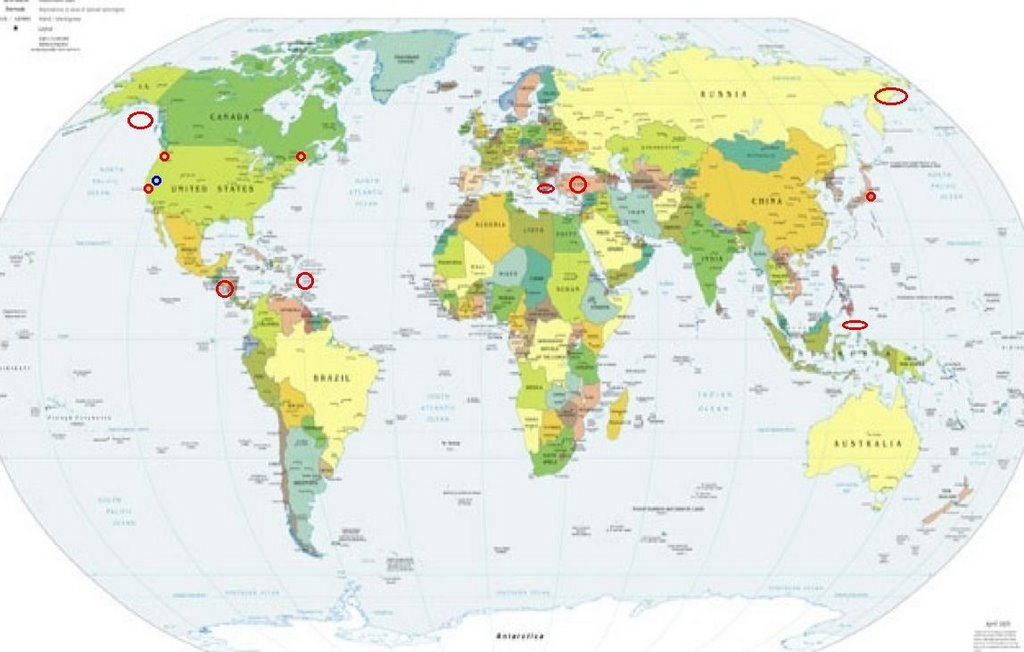
Places to watch.
Good luck to all.
For Wednesday, 11 October 2006.
---------------------------------------
TALAUD ISLANDS, INDONESIA (4.59N 125.58E)
(STRONG)
---------------------------------------
2006-10-09 14:12:22 4.7 20.17N 120.00E 20 Philippine Islands Region
2006-10-09 12:39:18 4.8 20.60N 119.85E 20 Philippine Islands Region
2006-10-09 11:43:39 4.9 20.51N 119.92E 20 Philippine Islands Region
2006-10-09 11:30:32 4.9 20.01N 118.98E 403 Philippine Islands Region
2006-10-09 11:08:30 5.9 20.78N 119.96E 20 Philippine Islands Region
2006-10-09 11:04:12 5.1 17.65N 121.28E 20 Luzon, Philippines
2006-10-09 10:57:07 4.9 20.68N 119.88E 40 Philippine Islands Region
2006-10-09 10:28:34 4.8 20.66N 119.97E 30 Philippine Islands Region
2006-10-09 10:01:48 6.1 20.78N 120.01E 20 Philippine Islands Region
(2 days early)
2006-10-10 23:17:14 4.8 20.54N 120.28E 10 Philippine Islands Region
2006-10-10 15:06:00 5.1 20.59N 119.85E 20 Philippine Islands Region
2006-10-10 00:00:47 4.9 20.74N 120.27E 10 Philippine Islands Region
2006-10-11 07:32:39 4.9 20.57N 119.64E 160 Philippine Islands Region
2006-10-11 06:43:56 5.9 20.73N 120.09E 23 Philippine Islands Region
2006-10-11 01:26:11 5.1 20.86N 119.97E 20 Philippine Islands Region
2006-10-11 01:24:00 4.9 20.92N 119.73E 20 Philippine Islands Region
(Off on the coordinates if these are for this symptom.)
San Simeon, CA area (35.721 -121.079)
(2 differnt symptoms - STRONG)
---------------------------------------
1.6 2006/10/10 18:07:13 35.644 -120.921 7.8 11km(7 mi) SSW of Lake Nacimiento, CA
1.3 2006/10/10 17:48:02 35.724 -121.104 5.6 12km(7 mi) NE of San Simeon, CA
1.7 2006/10/11 14:36:40 35.725 -121.114 6.7 11km(7 mi) NE of San Simeon, CA
Nicaragua and Coast of (11.29N 86.74W)
(2 different symptoms - STRONG)
---------------------------------------
06/10/11 21:53:15 9.72N 84.31W 155.3 3.6ML Costa Rica
06/10/11 20:23:24 12.28N 87.42W 3.2 1.9ML Frente a Corinto
06/10/11 11:00:38 13.97N 91.78W 1.0 5.2ML Frente a Guatemala
06/10/11 00:22:21 12.44N 87.84W 24.4 2.0ML Frente al Cosigüina
06/10/12 12:12:55 13.50N 88.08W 5.0 3.1ML El Salvador
Mt. St. Helen’s (Medium)
---------------------------------------
2.4 2006/10/11 01:29:34 46.194 -122.195 0.9 1 km ( 1 mi) WSW of Mount St. Helens Volcano, WA
1.6 2006/10/11 02:36:23 46.195 -122.196 0.5 1 km ( 1 mi) WSW of Mount St. Helens Volcano, WA
2.2 2006/10/11 11:38:15 46.194 -122.195 0.0 1 km ( 1 mi) WSW of Mount St. Helens Volcano, WA
2.1 2006/10/11 23:42:06 46.197 -122.188 0.3 1 km ( 0 mi) WSW of Mount St. Helens Volcano, WA
2.3 2006/10/12 08:11:01 46.195 -122.195 0.0 1 km ( 1 mi) WSW of Mount St. Helens Volcano, WA
2.3 2006/10/12 08:10:59 46.264 -122.225 7.9 8 km ( 5 mi) NNW of Mount St. Helens Volcano, WA
1.7 2006/10/12 13:01:09 46.194 -122.197 0.0 1 km ( 1 mi) WSW of Mount St. Helens Volcano, WA
2.4 2006/10/12 17:24:16 46.195 -122.194 0.3 1 km ( 1 mi) WSW of Mount St. Helens Volcano, WA
Turkey (Indication of depth - Strong)
---------------------------------------
2006-10-11 02:25:01.2 37.27N 42.51E 9 MD3.0 TURKEY
2006-10-11 18:58:43.4 39.31N 27.81E 18 MD2.9 TURKEY
2006-10-12 03:20:06.9 37.87N 29.23E 10 ML4.2 TURKEY
2006-10-12 18:12:32.2 40.42N 28.35E 11 MD3.3 TURKEY
2006-10-12 19:14:46.9 37.78N 36.52E 14 MD3.0 TURKEY
(Nothing very deep)
Honshu, Japan area
---------------------------------------
2006-10-12 00:48:36 5.0 25.52N 140.30E 195 Volcano Islands, Japan Region
British Virgin Islands (MEDIUM)
---------------------------------------
3.1 2006/10/11 18:10:26 18.786N -65.192W 24.9 55 km (34 mi) NNE of Culebra, PR
3.6 2006/10/11 15:11:52 18.543N -68.591W 184.7 15 km ( 9 mi) SE of Higüey, La Altagracia, Dominican Republic
2.5 2006/10/11 07:35:48 18.484N -66.806W 88.9 2 km ( 1 mi) E of Hatillo, PR
2.3 2006/10/11 03:50:15 17.907N -66.030W 11.6 8 km ( 5 mi) SSE of Arroyo, PR
3.2 2006/10/11 01:05:48 18.113N -67.940W 113.4 77 km (48 mi) WSW of Stella, PR
(Not Virgin Islands)
Possibly Lake Tahoe area (New symptom)
---------------------------------------
1.0 2006/10/10 11:13:34 39.235 -120.092 9.1 4 km ( 2 mi) WSW of Tahoe Vista, CA
2.4 2006/10/11 00:43:11 40.546 -122.323 13.4 5 km ( 3 mi) SE of Redding, CA
Maine (44.31N 68.15W) (MEDIUM)
---------------------------------------
2006/10/11 11:33:09 46.14N 75.35W 18.0* 2.5MN 47 km S from Mont-Laurier,QC
(Possible quake for the symptom - this area is difficult to pinpoint)
Aegean Sea/Greece area
---------------------------------------
2006-10-11 17:16:56.0 36.83N 26.53E ML3.1 DODECANESE ISLANDS, GREECE
2006-10-11 12:30:02.0 37.92N 26.35E ML3.3 DODECANESE ISLANDS, GREECE
2006-10-11 00:39:05.0 37.93N 22.86E ML3.0 SOUTHERN GREECE
2006-10-12 09:53:26.0 36.49N 21.09E 10f ML3.6 SOUTHERN GREECE
2006-10-12 13:31:00.6 34.23N 26.59E 40f mb4.6 CRETE, GREECE
Gulf of Alaska
---------------------------------------
(Nothing found)
Eastern Siberia
---------------------------------------
(Nothing found)
Peace to all.

posted by Unknown @ 2:39 PM
0 comments
![]()
![]()
