*For Tuesday, 18 April 2006.
LEGEND for OVERVIEW: Size = My surety of area for quake.
Red Circle = Probable quake to STRONG quake.
Triangle = Very Strong or Stronger quake (And usually takes extra days).
Blue Circle, etc. = Uncertainty of symptom area for probable quake.
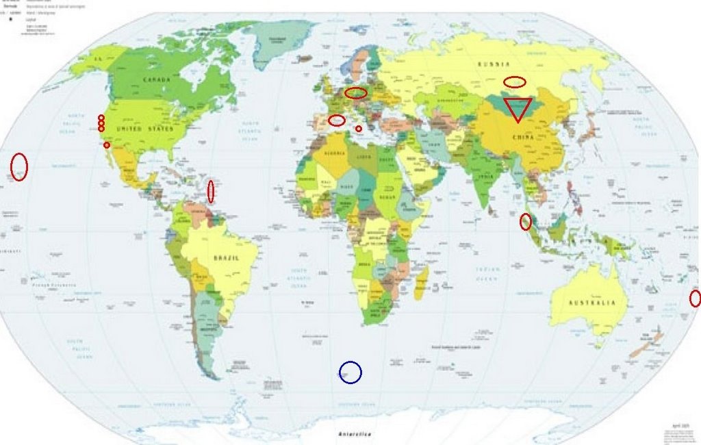
Places to watch.
Good luck to all.
For Tuesday, 18 April 2006.
----------------------------------------
Northern Sumatra area
----------------------------------------
2006-04-19 19:50:59.8 1.70 N 96.81 E 5 mb 5.0 OFF W. CST OF NORTHERN SUMATERA
2006-04-19 20:36:53.3 3.71 N 93.09 E 40 mb 5.4 OFF W. CST OF NORTHERN SUMATERA
Hawaii and North of
----------------------------------------
MAP 2.2 2006/04/18 09:58:39 19.423 -156.010 9.8 13 km ( 8 mi) W of Honaunau-Napoopoo, HI
MAP 2.3 2006/04/18 19:14:18 19.238 -155.554 5.7 9 km ( 5 mi) WNW of Pahala, HI
MAP 2.0 2006/04/19 01:13:13 19.398 -155.257 1.5 6 km ( 4 mi) SSW of Volcano, HI
Petrolia, California (Medium)
----------------------------------------
MAP 3.6 2006/04/16 22:25:42 40.379 -124.917 11.3 54 km ( 33 mi) W of Petrolia, CA
(2 days early)
MAP 2.3 2006/04/18 20:59:18 40.559 -123.557 27.9 35 km ( 22 mi) W of Hayfork, CA
MAP 2.4 2006/04/19 03:33:17 40.322 -124.456 6.0 14 km ( 9 mi) W of Petrolia, CA
Sicily, Italy (Medium)
----------------------------------------
2006-04-18 00:05:39.0 37.54 N 20.88 E ML 3.0 IONIAN SEA
2006-04-18 08:56:41.2 37.66 N 20.92 E 10 ML 3.3 IONIAN SEA 2006-04-18 12:11
2006-04-18 08:26:06.9 37.74 N 20.94 E 5 ML 3.6 IONIAN SEA
2006-04-18 11:00:21.9 41.45 N 20.28 E 2 ML 3.0 ALBANIA
Possibly Bouvet Island/South of Africa
----------------------------------------
2006-04-20 14:31:28.9 49.37 S 7.81 W 10 G M 4.5 SOUTHERN MID-ATLANTIC RIDGE
2006-04-20 15:12:19.9 49.43 S 8.01 W 33 mb 5.0 SOUTHERN MID-ATLANTIC RIDGE
2006-04-20 16:50:14.8 49.39 S 7.97 W 10 G M 4.8 SOUTHERN MID-ATLANTIC RIDGE
(2 extra days - not quite as South as expected and more energy than expected.)
Moraga, California area (37.811 -122.069) (Strong)
----------------------------------------
MAP 1.0 2006/04/18 20:54:53 37.840 -122.006 8.7 3 km ( 2 mi) SE of Alamo, CA
MAP 1.0Q 2006/04/18 18:54:50 37.041 -122.142 0.1 1 km ( 1 mi) N of Quarry near Davenport, CA(Probable quarry explosion)
The Geysers
----------------------------------------
9 2006/04/18 02:38:57 38.794 -122.778 4.7 3 km ( 2 mi) E of The Geysers, CA
MAP 2.3 2006/04/18 14:35:07 38.799 -122.796 1.9 1 km ( 1 mi) E of The Geysers, CA
MAP 1.5 2006/04/18 21:01:35 38.825 -122.827 3.0 4 km ( 2 mi) NNW of The Geysers, CA
MAP 1.6 2006/04/18 23:39:15 38.807 -122.826 4.0 2 km ( 1 mi) WNW of The Geysers, CA
Lake Baykal area (medium)
----------------------------------------
(Nothing found)
Germany/Poland area
----------------------------------------
2006-04-18 00:12:01.0 51.62 N 13.81 E 33 ML 3.4 GERMANY
Tonga and South of
----------------------------------------
2006-04-19 12:13:44.8 20.46 S 178.68 W 600 f mb 4.8 FIJI ISLANDS REGION
2006-04-19 15:30:08.0 20.85 S 174.57 W 33 f mb 5.1 TONGA ISLANDS
The Virgin Islands
----------------------------------------
MAP 3.2 2006/04/18 13:31:21 17.994 -67.072 10.8 3 km ( 2 mi) NW of La Parguera, PR
Mongolia (Second day symptom and I already have this as STRONG so will up it to Very Strong)
http://www.mongoliaphotogallery.com/>Mongolia

----------------------------------------
(Nothing found)
Baja California area (32.023N 116.306W) (medium)
----------------------------------------
MAP 1.9 2006/04/18 09:49:11 32.706 -116.061 3.7 7 km ( 4 mi) WSW of Ocotillo, CA
MAP 1.9 2006/04/18 09:48:03 32.705 -116.050 7.7 6 km ( 4 mi) SW of Ocotillo, CA
MAP 1.7 2006/04/19 03:04:24 32.410 -116.939 8.6 7 km ( 5 mi) ESE of La Joya, Mexico
France/Western Mediterranean
----------------------------------------
(Nothing found)
Peace to all.

posted by Unknown @ 1:21 PM
0 comments
![]()
![]()
