*For Thursday, 9 February 2006.
LEGEND for OVERVIEW:
Size = My surety of area for quake.
Red Circle = Probable quake to STRONG quake.
Triangle = Very Strong or Stronger quake (And usually takes extra days).
Blue Circle, etc. = Uncertainty of symptom area for probable quake.
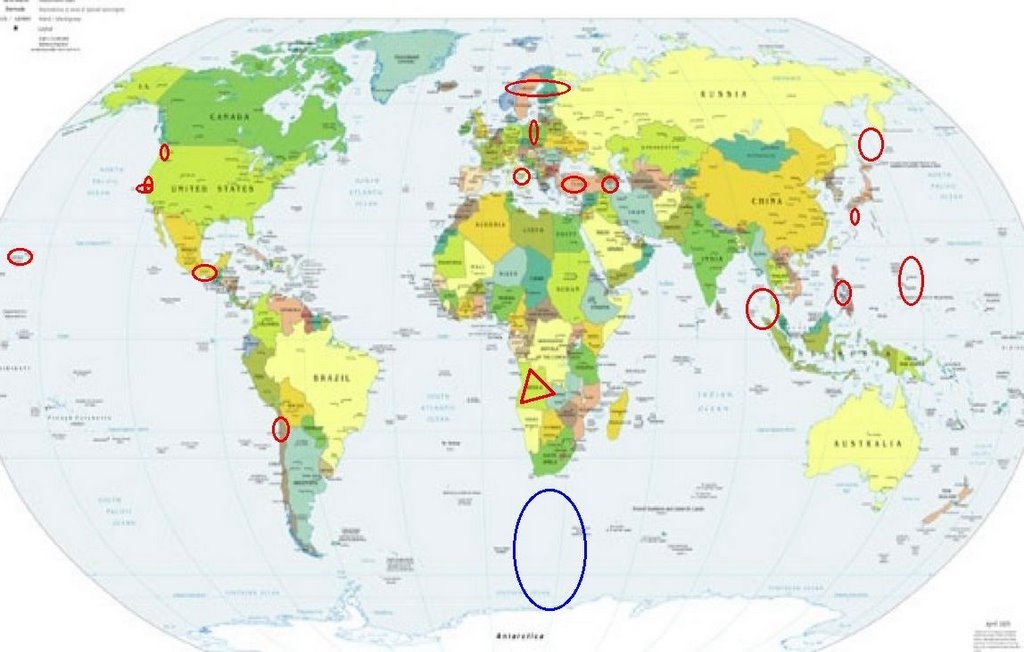
Places to watch.
Good luck to all.
For Thursday, 9 February 2006.
----------------------------------------
Parkfield/Pinnacles and in between
----------------------------------------
MAP 2.6 2006/02/09 08:18:06 36.962 -121.599 5.3 6 km ( 4 mi) SSW of Gilroy, CA
MAP 1.7 2006/02/09 09:41:15 36.559 -121.079 8.0 7 km ( 4 mi) ENE of Pinnacles, CA
MAP 1.1 2006/02/09 09:59:44 36.966 -121.600 3.4 5 km ( 3 mi) SSW of Gilroy, CA
MAP 1.6 2006/02/09 21:56:36 36.016 -120.587 0.6 19 km ( 12 mi) NW of Parkfield, CA
MAP 2.5 2006/02/09 22:23:24 36.282 -120.865 9.5 22 km ( 14 mi) NE of San Lucas, CA
MAP 1.5 2006/02/10 00:59:48 36.008 -120.575 4.0 18 km ( 11 mi) NW of Parkfield, CA
MAP 1.4 2006/02/10 05:08:36 36.480 -121.058 7.5 9 km ( 6 mi) SE of Pinnacles, CA
MAP 1.7 2006/02/10 18:32:58 36.539 -121.128 6.8 2 km ( 1 mi) ENE of Pinnacles, CA
MAP 1.7 2006/02/10 21:48:09 36.652 -121.278 8.3 16 km ( 10 mi) SSE of Tres Pinos, CA
MAP 2.5Q 2006/02/10 22:23:41 36.899 -121.623 5.0 1 km ( 1 mi) SSE of Quarry near Logan (Watsonville), CA(Probable quarry explosion)
Hawaii (MEDIUM)
----------------------------------------
MAP 2.1 2006/02/08 01:22:05 19.370 -155.229 3.3 9 km ( 6 mi) S of Volcano, HI
MAP 2.0 2006/02/08 07:00:43 20.148 -155.622 12.4 6 km ( 4 mi) WNW of Kukuihaele, HI
MAP 2.0 2006/02/08 08:55:16 19.391 -155.248 3.2 7 km ( 4 mi) S of Volcano, HI
MAP 2.0 2006/02/08 11:35:45 19.394 -155.244 3.2 6 km ( 4 mi) S of Volcano, HI
MAP 2.1 2006/02/08 13:22:15 19.392 -155.247 3.9 7 km ( 4 mi) S of Volcano, HI
MAP 1.9 2006/02/08 18:07:13 19.387 -155.274 4.1 8 km ( 5 mi) SSW of Volcano, HI
MAP 2.3 2006/02/08 18:04:44 19.382 -155.235 3.8 8 km ( 5 mi) S of Volcano, HI
MAP 1.9 2006/02/08 17:50:17 19.387 -155.246 2.8 7 km ( 4 mi) S of Volcano, HI
MAP 1.9 2006/02/08 21:29:59 19.384 -155.242 4.6 7 km ( 5 mi) S of Volcano, HI
MAP 3.1 2006/02/08 21:28:12 19.386 -155.243 3.3 7 km ( 4 mi) S of Volcano, HI
MAP 1.7 2006/02/09 07:52:55 19.391 -155.250 2.5 7 km ( 4 mi) SSW of Volcano, HI
MAP 2.0 2006/02/09 08:50:52 19.381 -155.241 3.5 8 km ( 5 mi) S of Volcano, HI
MAP 1.7 2006/02/09 17:49:35 19.384 -155.244 2.8 7 km ( 5 mi) S of Volcano, HI
MAP 2.0 2006/02/09 18:15:59 19.390 -155.248 2.6 7 km ( 4 mi) S of Volcano, HI
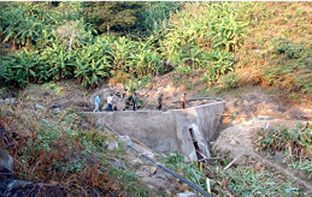
Angola, Africa (14.3S 16.0E) (EXTREMELY STRONG)
http://www.usaid.gov/locations/sub-saharan_africa/countries/angola/>Angola
Rural Angola Reseroir
----------------------------------------
2006-02-11 21:49:13.9 25.84S 2.48W 33 mb4.9 SOUTH ATLANTIC OCEAN
Mariana Islands
----------------------------------------
MAP 6.2 2006/02/14 15:27:25 20.816 146.186 52.8 MARIANA ISLANDS REGION
(5 extra days!)
Italy (MEDUIUM)
----------------------------------------
2006-02-09 01:01:00.0 42.77N 12.78E 8 ML3.2 CENTRAL ITALY
2006-02-09 05:55:00.0 42.76N 12.81E 1 ML2.8 CENTRAL ITALY
2006-02-09 22:22:00.0 42.76N 12.79E 8 ML2.1 CENTRAL ITALY
Seattle area (Possible volcanics - still having trouble with right neck symptoms - might be Mt. Rainier or Glacier Peak.)
----------------------------------------
2006/02/09 19:26:26 47.39N 121.94W 1F 2.5 38 km SE Seattle WA
Andaman/Northern Sumatra area (Strong)
----------------------------------------
10Feb2006 05:24:53.3 2.2N 96.9E 33 mb=5.2 M GSR NORTHERN SUMATERA, INDONES0616
10Feb2006 07:39:53.7 1.2N 97.4E 33 MS=4.6 M GSR NORTHERN SUMATERA, INDONES0847
Southern Mexico
----------------------------------------
MAP 4.2 2006/02/09 06:54:31 17.791 -105.936 51.5 OFF THE COAST OF JALISCO, MEXICO
Possibly South of Africa to Antarctic (Unproven symptom) (STRONG)
----------------------------------------
2006-02-08 05:04:56.1 54.50S 143.86E 40 mb5.2 WEST OF MACQUARIE ISLAND
2006-02-08 06:39:44.8 53.46S 140.64E 33 Ms 4.5 WEST OF MACQUARIE ISLAND????
Mammoth Lakes/Tom's Place area (Medium)
----------------------------------------
MAP 1.6 2006/02/08 07:56:29 37.513 -118.872 7.2 17 km ( 10 mi) SE of Mammoth Lakes, CA
MAP 1.4 2006/02/09 17:43:35 37.480 -118.540 12.5 9 km ( 6 mi) NE of Round Valley, CA
Turkey (Medium)
----------------------------------------
2006-02-08 04:11:16.3 40.69N 30.32E 10 MD 3.1 TURKEY
2006-02-08 04:07:41.2 40.74N 30.35E 10 mb 4.3 TURKEY
2006-02-08 05:24:25.6 40.72N 30.35E 10 ML 3.7 TURKEY
2006-02-08 10:25:10.0 38.15N 26.70E 15f Ms 3.4 AEGEAN SEA
2006-02-09 06:00:00.2 38.41N 39.13E 3 MD 3.4 TURKEY
2006-02-09 10:03:26.0 39.04N 37.15E 27 ML 4.1 TURKEY
2006-02-09 13:36:51.2 39.76N 32.20E 5 MD 3.4 TURKEY
Kyushu/Ryukyu area
----------------------------------------
(Nothing found)
Central Philippines (Strong)
----------------------------------------
2006-02-08 00:13:26.3 7.82N 125.20E 30 mb4.9 MINDANAO, PHILIPPINE ISLANDS
Boulder Creek, California area (37.070 -122.272)
----------------------------------------
MAP 1.1 2006/02/08 22:56:10 37.013 -122.133 8.3 8 km ( 5 mi) WSW of Felton, CA
MAP 1.9Q 2006/02/08 22:19:21 37.322 -122.102 0.0 0 km ( 0 mi) S of Quarry near Cupertino, CA(Probable quarry explosion)
MAP 1.2 2006/02/09 20:24:46 37.058 -121.823 6.3 6 km ( 4 mi) NNE of Day Valley, CA
Iran/Armenia/Azerbaijan area (39.92N 44.50E)
----------------------------------------
(Nothing found)
Poland
----------------------------------------
2006-02-08 05:00:07.2 51.30N 16.03E 2 ML 2.5 POLAND
2006-02-08 17:10:48.6 51.20N 15.96E 10 ML2.7 POLAND
2006-02-09 00:20:02.6 51.20N 15.96E 10 ML2.2 POLAND
2006-02-09 05:59:53.0 53.38N 19.73E 33 ML3.8 POLAND
Finland/Sweden/Norway
----------------------------------------
2006-02-10 17:06:21.8 78.42N 12.98E 25 mb 3.9 SVALBARD, NORWAY, REGION
Kuril Islands to Sea of Okhotsk (Strong)
----------------------------------------
MAP 4.8 2006/02/08 14:56:47 50.057 154.850 131.6 KURIL ISLANDS
300 earthquakes registered on Karymsky volcano on Kamchatka
09.02.2006, 12.42
PETROPAVLOVSK-KAMCHATSKY, February 9 (Itar-Tass) - About 300 local earthquakes were registered on the Karymsky volcano on the Kamchatka Peninsula on Thursday. The giant volcano is spewing ash. The plume rise is 1.5 kilometres. There is no danger to nearby populated localities.
The Kamchatka-based seismic crew specialists told Itar-Tass the plume of ash from the crater has stretched for some 20 kilometres at the height of four kilometres above sea level. A 40-kilometre cloud containing volcanic dust is observed some 40 kilometres east of the volcano.
The Karymsky is one of the most active Kamchatka volcanoes. Its height exceeds 1,500 metres. The volcano has been in the state of eruption for 10 years since January 1996. Scientists are monitoring the volcano state without interruption.
300 earthquakes registered on Karymsky volcano on Kamchatka
Northern Chile area
----------------------------------------
2006-02-10 17:51:53.6 32.74S 71.65W 40 mb 5.0 NEAR COAST OF CENTRAL CHILE
Peace to all.

posted by Unknown @ 12:02 PM
0 comments
![]()
![]()
