*For Sunday, 15 January 2006.
LEGEND for OVERVIEW:
Size = My surety of area for quake.
Red Circle = Probable quake to STRONG quake.
Triangle = Very Strong or Stronger quake (And usually takes extra days).
Blue Circle, etc. = Uncertainty of symptom area for probable quake.
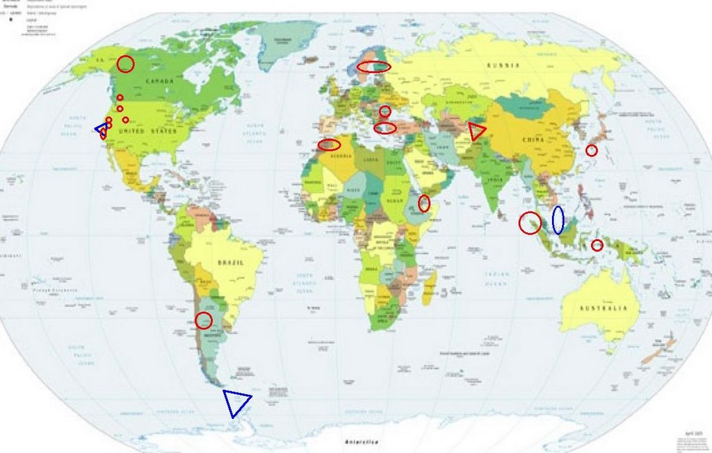
Places to watch.
Good luck to all.
For Sunday, 15 January 2006.
----------------------------------------
San Juan Province, Argentina and South of (31.45 S 68.51 W)
----------------------------------------
MAP 4.2 2006/01/14 01:34:54 -24.015 -66.727 191.7 JUJUY, ARGENTINA
MAP 4.1 2006/01/16 16:23:32 -32.231 -71.542 35.9 OFFSHORE VALPARAISO, CHILE
Northern Sumatra and then possibly South China Sea
----------------------------------------
16Jan2006 14:58:53.7 9.8N 91.5E200 mb=4.4 M GSR NICOBAR ISLANDS, INDIA 1626
Finland/Sweden/Norway (Medium)
----------------------------------------
JAEMTLAND SWEDEN
Origin time Lat Lon Azres Timres Wres Nphase Ntot Nsta Netmag
2006-015:00.16.32.0 64.23 13.48 0.75 1.93 2.12 3 4 1 2.76
Mammoth Lakes/Tom's Place
----------------------------------------
map 2.7 2006/01/14 07:09:44 37.487 -118.835 4.4 16 km ( 10 mi) WSW of Toms Place, CA
map 1.7 2006/01/14 07:13:41 37.486 -118.838 4.1 16 km ( 10 mi) WSW of Toms Place, CA
map 2.0 2006/01/14 08:37:36 37.491 -118.835 3.7 16 km ( 10 mi) WSW of Toms Place, CA
map 1.3 2006/01/14 09:59:16 37.486 -118.837 3.1 16 km ( 10 mi) WSW of Toms Place, CA
Afghanistan-Tajikistan border/Hindu Kush (VERY STRONG - Symptoms don't usually wake me up but this one did. Left ring finger knuckle at nail phalanx.)
Afghanistan Information

----------------------------------------
2006/01/15 22:12:13.0 38.87 N 71.95 E ML3.3 AFGHANISTAN-TAJIKISTAN BDR REG
16Jan2006 17:12:05.6 39.5N 71.9E 33 MS=3.7 M GSR TAJIKISTAN 1836
British Columbia, Canada
----------------------------------------
2006/01/15 23:37:40 59.08N 135.89W 10F 2.3 38 km W Haines AK
2006/01/15 18:21:20 51.14N 130.75W 10F 2.4 214 km WSW Bella BellaBC
2006/01/15 14:54:26 53.84N 132.27W 10 1.0 21 km SSW Masset BC
MAP 3.6 2006/01/15 12:29:46 48.570 -123.530 44.0 14 km ( 8 mi) NW of Saanich, Canada
Possibly South Shetland Islands (VERY STRONG)
South Shetland Islands

----------------------------------------
MAP 4.6 2006/01/14 04:39:47 -41.093 -91.334 10.0 SOUTHEAST OF EASTER ISLAND
(More North and West than guessed)
San Francisco and then inland (VERY STRONG for San Francisco)
San Francisco

----------------------------------------
map 2.0 2006/01/15 20:53:56 37.658 -122.058 4.3 2 km ( 1 mi) S of Fairview, CA
map 1.5 2006/01/15 07:14:15 37.389 -121.513 3.9 28 km ( 17 mi) E of Alum Rock, CA
map 1.5 2006/01/15 09:47:25 37.389 -121.515 3.6 28 km ( 17 mi) E of Alum Rock, CA
MAP 3.6 2006/01/15 10:42:07 37.388 -121.514 3.2 28 km ( 17 mi) E of Alum Rock, CA
map 2.0 2006/01/15 20:53:56 37.658 -122.058 4.3 2 km ( 1 mi) S of Fairview, CA
The Moluccas/Banda Sea (Strong)
----------------------------------------
(2006/01/15 11:58:27.3 8.08 S 122.51 E 264 mb6.4 FLORES, INDONESIA, REGION - This was felt mostly for the 13th and also posted it there. I am a little confused at getting continued symptoms for an area and how to post for them better. Still working on this.)
Utah
----------------------------------------
map 2.3 2006/01/15 17:02:51 37.900 -112.985 7.5 15 km ( 9 mi) WNW of Parowan, UT
map 1.5 2006/01/15 19:41:12 39.606 -110.394 0.0 6 km ( 4 mi) N of Sunnyside, UT
map 1.5 2006/01/15 20:08:03 39.706 -110.591 1.3 22 km ( 14 mi) ENE of Price, UT
map 1.4 2006/01/15 23:13:52 39.711 -110.739 0.1 10 km ( 6 mi) ENE of Helper, UT
Covelo, California area (40.056 -123.262) (Medium)
----------------------------------------
map 2.5 2006/01/15 18:11:00 40.399 -124.149 19.1 12 km ( 7 mi) SSW of Rio Dell, CA
Romania
----------------------------------------
(Nothing found)
Kyushu/Ryukyu, Japan area (Medium)
----------------------------------------
(Nothing found)
Wenatchee, Washington (47.307N 119.809W) (Second or third day of symptoms for this area - Strong)
----------------------------------------
(Nothing found)
Yukon Territories
----------------------------------------
MAP 4.5 2006/01/14 23:51:22 67.474 -135.388 15.0 NORTHWEST TERRITORIES, CANADA
Cayucos, California area (35.533°N, 120.834°W)
----------------------------------------
map 2.5 2006/01/15 11:39:57 35.589 -120.979 2.3 11 km ( 7 mi) ENE of Cambria, CA
Greece/Turkey (Medium)
----------------------------------------
2006/01/15 00:53:04.5 38.14 N 26.93 E 4 MD3.1 AEGEAN SEA
2006/01/15 04:28:35.7 38.45 N 41.47 E 8 MD3.3 TURKEY
2006/01/15 04:37:38.2 37.11 N 27.96 E 30 MD2.9 TURKEY
2006/01/15 16:36:53.6 37.49 N 30.79 E 26 MD3.0 TURKEY
2006/01/15 16:45:57.3 39.68 N 38.73 E 10 ML4.1 TURKEY
Algeria/Morocco area.
----------------------------------------
2006/01/16 12:19:54.2 34.02 N 5.03 W mb4.0 MOROCCO
2006/01/17 00:42:29.1 34.05 N 4.90 W mb3.2 MOROCCO
(2 extra days)
Western Arabian Peninsula (12.10 N 43.80 E) (Medium)
----------------------------------------
(Nothing found)
Peace to all.

posted by Unknown @ 2:13 PM
0 comments
![]()
![]()
