*For Friday, 5 May 2006.
LEGEND for OVERVIEW: Size = My surety of area for quake.
Red Circle = Probable quake to STRONG quake.
Triangle = Very Strong or Stronger quake (And usually takes extra days).
Blue Circle, etc. = Uncertainty of symptom area for probable quake.
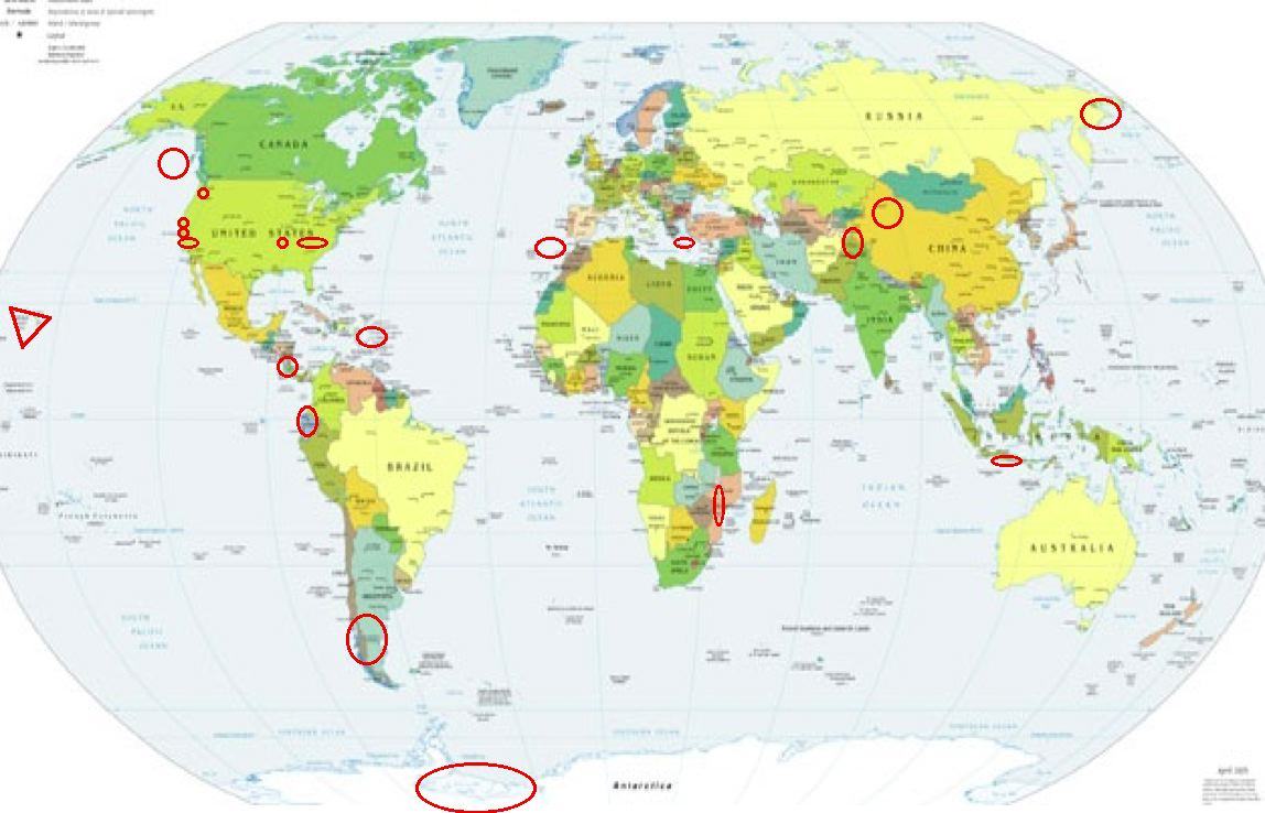
Places to watch.
Good luck to all.
For Friday, 5 May 2006.
----------------------------------------
Ecuador
----------------------------------------
(Nothing found)
Mt. St. Helen’s (MEDIUM)
----------------------------------------
MAP 1.6 2006/05/05 06:10:42 46.197 -122.190 0.9 1 km ( 1 mi) WSW of Mount St. Helens Volcano, WA
MAP 2.7 2006/05/05 09:01:53 46.198 -122.190 0.0 1 km ( 1 mi) WSW of Mount St. Helens Volcano, WA
MAP 1.1 2006/05/05 12:02:02 46.197 -122.190 0.9 1 km ( 1 mi) WSW of Mount St. Helens Volcano, WA
SOUTHERN XINJIANG, CHINA (41.769 87.902)
----------------------------------------
2006-05-04 17:17:23.0 40.00 N 78.83 E ML 3.7 SOUTHERN XINJIANG, CHINA
Lake Nacimiento area (35.737 -121.036)
----------------------------------------
MAP 3.4 2006/05/04 17:45:07 35.743 -121.239 11.8 12 km ( 7 mi) NNW of San Simeon, CA
Islamabad, Pakistan
----------------------------------------
2006-05-05 08:01:54 4.8 35.69 N 70.18 E Hindu Kush Region, Afghanistan
2006-05-05 03:50:51.3 36.53 N 71.09 E 120 mb 4.5 AFGHANISTAN-TAJIKISTAN BDR REG
2006-05-05 16:33:21.0 38.09 N 70.39 E ML 3.3 AFGHANISTAN-TAJIKISTAN BDR REG
The New Madrid Fault/Probably Missouri and another place much further East (Medium for both)
----------------------------------------
MAP 1.5 2006/05/03 19:31:18 36.110 -89.440 12.2 9 km ( 6 mi) NNW of Dyersburg, TN
(2 days early)
MAP 1.5 2006/05/05 02:02:56 36.460 -89.540 7.6 9 km ( 6 mi) SE of Marston, MO
MAP 1.6 2006/05/05 03:59:45 36.220 -89.460 8.1 5 km ( 3 mi) SSE of Ridgely, TN
MAP 1.7 2006/05/05 23:47:28 36.260 -89.460 6.1 2 km ( 1 mi) ESE of Ridgely, TN
Irian Jaya, Indonesia (2.80 S 138.82 E) (Strong)
----------------------------------------
2006-05-04 11:18:21 4.7 2.57 S 141.55 E Near n Coast of New Guinea, PNG.
Southern Chile/Southern Argentina area
----------------------------------------
2006-05-05 08:04:20.6 27.21 S 71.17 W 40 mb 4.9 NEAR COAST OF NORTHERN CHILE
(Not Southern)
Crete area
----------------------------------------
2006-05-05 05:34:46.9 37.23 N 26.63 E 21 MD 2.9 DODECANESE ISLANDS, GREECE
2006-05-05 06:16:09.4 38.33 N 22.70 E 10 ML 4.2 GREECE
2006-05-05 08:44:21.0 35.12 N 24.21 E ML 3.2 CRETE, GREECE
Antarctica/Possibly Mt. Erebus
----------------------------------------
(Nothing found)
KORYAKIA, RUSSIA (61.084 165.601) (Strong)
----------------------------------------
(Came in on 7th, 8th, and 9th - posted on the 6th.)
The Geysers (Strong)
----------------------------------------
MAP 1.4 2006/05/05 00:02:52 38.817 -122.816 3.5 2 km ( 1 mi) NNW of The Geysers, CA
MAP 1.8 2006/05/05 04:21:21 38.824 -122.792 3.8 3 km ( 2 mi) NNE of The Geysers, CA
MAP 1.2 2006/05/05 20:38:34 38.831 -122.796 2.2 4 km ( 2 mi) NNE of The Geysers, CA
The Gulf of Alaska (Strong)
----------------------------------------
MAP 3.8 2006/05/04 00:25:43 58.634 -145.867 50.0 GULF OF ALASKA
Nicaragua/Costa Rica area (Medium)
----------------------------------------
06/05/05 14:40:56 11.95N 87.13W 5.0 2.9ML Frente a Puerto Sandino
06/05/05 12:22:29 12.54N 88.18W 48.4 2.9ML Frente al Golfo de Fonseca
06/05/05 10:34:31 12.31N 88.26W 7.2 3.4ML Frente al Cosigüina
06/05/05 00:43:51 12.45N 90.97W 100.0 4.4ML Frente a El Salvador
Mozambique
----------------------------------------
(Nothing found)
Hawaii (Very Strong)
http://www.lilikoicandles.com/photoclipart/clipartscenic.html>lilikoicandles

----------------------------------------
MAP 2.4 2006/05/05 09:38:54 19.413 -155.320 5.3 10 km ( 6 mi) WSW of Volcano, HI
MAP 2.0 2006/05/05 16:32:55 18.937 -155.413 39.6 23 km ( 14 mi) SE of Naalehu, HI
Parkfield, California and East of (MEDIUM)
----------------------------------------
MAP 2.5 2006/05/04 16:35:36 36.613 -120.541 10.7 21 km ( 13 mi) SW of Mendota, CA
MAP 1.6 2006/05/05 08:17:48 35.899 -120.444 12.0 1 km ( 1 mi) W of Parkfield, CA
Strait of Gibraltar area (Medium)
----------------------------------------
2006-05-05 16:02:05.3 36.67 N 7.25 W 2 ML 3.8 STRAIT OF GIBRALTAR
Puerto Rico/Virgin Islands
----------------------------------------
MAP 2.4 2006/05/05 01:23:52 18.400 -67.257 27.1 7 km ( 4 mi) N of Rincón, PR
MAP 2.1 2006/05/05 09:13:16 17.926 -66.869 16.2 6 km ( 4 mi) SSE of María Antonia, PR
MAP 2.9 2006/05/05 10:32:09 18.935 -66.292 24.0 52 km ( 32 mi) N of Breñas, PR
MAP 2.8 2006/05/05 12:43:36 18.919 -66.288 25.1 50 km ( 31 mi) N of Breñas, PR
MAP 1.9 2006/05/05 13:05:40 17.959 -66.572 16.2 7 km ( 5 mi) SSW of Capitanejo, PR
MAP 1.9 2006/05/05 13:54:32 18.009 -66.781 9.7 2 km ( 1 mi) SW of Magas Arriba, PR
Peace to all.

posted by Unknown @ 12:17 PM
0 comments
![]()
![]()
