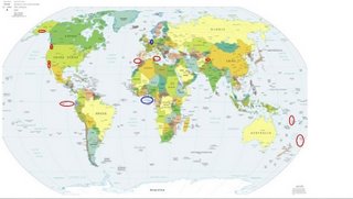
*For Thursday, 31 August 2006.
LEGEND for OVERVIEW: Size = My surety of area for quake.
Red Circle = Probable quake to STRONG quake.
Triangle = Very Strong/Stronger quake (Usually takes extra days).
Blue Circle, etc. = Uncertainty of symptom area for probable quake.

Places to watch.
Good luck to all.
For Thursday, 31 August 2006.
---------------------------------------
Maneadero, Mexico area (31.839 -116.272)
(STRONG)
---------------------------------------
(Nothing found)
Northern Tunisia/Central Mediterranean Sea
(Strong)
---------------------------------------
2006-08-31 01:34:40.3 35.92N 20.95E 10f ML3.9 CENTRAL MEDITERRANEAN SEA
Vanuatu (14.86S 167.90E)(Strong)
---------------------------------------
2006-09-01 19:56:00 5.2 21.24S 174.38E 20 Vanuatu Islands Region
2006-09-01 19:26:44 5.3 24.47S 168.81E 333 Southwest of New Caledonia
Mt. St. Helen’s (MEDIUM)
and
Mossyrock, Washington area (46.520 -122.402)
---------------------------------------
2.1 2006/08/31 03:33:15 46.196 -122.189 0.0 1 km ( 1 mi) WSW of Mount St. Helens Volcano, WA
1.2 2006/08/31 03:45:05 45.818 -122.603 18.0 3 km ( 2 mi) NW of Cherry Grove, WA
1.3 2006/08/31 07:07:48 46.533 -122.453 26.0 2 km ( 2 mi) E of Mossyrock, WA
1.9 2006/08/31 16:19:40 46.196 -122.189 0.0 1 km ( 1 mi) WSW of Mount St. Helens Volcano, WA
1.8 2006/08/31 20:12:23 46.196 -122.195 0.3 1 km ( 1 mi) WSW of Mount St. Helens Volcano, WA
Hindu Kush/Islamabad, Pakistan area (Strong)
---------------------------------------
2006-08-31 18:02:19.2 36.50N 70.95E 118 mb4.7 HINDU KUSH, AFGHANISTAN, REG
Obsidian Butte, CA area (33.188 -115.649)
---------------------------------------
1.6 2006/08/31 06:49:55 33.175 -115.612 0.2 2 km ( 1 mi) ENE of Obsidian Butte, CA
1.6 2006/08/31 06:42:06 33.193 -115.612 1.6 3 km ( 2 mi) NE of Obsidian Butte, CA
1.6 2006/08/31 06:37:21 33.178 -115.602 1.1 3 km ( 2 mi) ENE of Obsidian Butte, CA
Strait of Gibraltar/Morocco area
---------------------------------------
2006-09-01 22:59:28.9 34.58N 10.36 W mb3.7 MADEIRA ISLANDS,PORTUGAL REG
Alaska Peninsula (Medium)
---------------------------------------
2.9 2006/08/31 23:59:33 60.943 -149.675 43.0 KENAI PENINSULA, ALASKA
2.8 2006/09/01 13:36:50 57.803 -157.096 180.9 ALASKA PENINSULA
3.3 2006/09/01 22:12:54 58.950 -154.925 100.0 ALASKA PENINSULA
Kermadec Islands/large area around
---------------------------------------
2006-09-01 04:37:11.5 32.74S 178.74W 30 mb5.1 SOUTH OF KERMADEC ISLANDS
2006-09-01 06:34:57.9 32.83S 178.86W 30 mb5.4 SOUTH OF KERMADEC ISLANDS
Off the Coast of Peru/Galapagos
Islands area (Indication of depth - Strong)
---------------------------------------
2006-09-01 03:50:39.7 19.42N 108.96W 10G M4.5 REVILLA GIGEDO IS.MEXICO?
(If this is right - way farther north and not that deep.)
2006-09-01 15:52:33.4 25.55S 70.65W 1 mb5.1 NEAR COAST OF NORTHERN CHILE
(Certainly not deep)
Possibly Belgium area (Unproven symptom)
---------------------------------------
(Nothing found)
Possibly South Atlantic Ocean area
(8.17S 8.95W) (Unproven symptom)
---------------------------------------
2006-08-31 05:44:07.5 16.90S 15.24W 33 mb5.0 SOUTHERN MID-ATLANTIC RIDGE
Peace to all.

