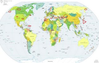
*For Wednesday, 26 July 2006.
LEGEND for OVERVIEW: Size = My surety of area for quake.
Red Circle = Probable quake to STRONG quake.
Triangle = Very Strong/Stronger quake (Usually takes extra days).
Blue Circle, etc. = Uncertainty of symptom area for probable quake.

Places to watch.
(This is the first time that I
have noticed only Northern
Hemisphere symptoms for
one day.)
Good luck to all.
For Wednesday, 26 July 2006.
----------------------------------------
Caspian Sea/Iran border area
----------------------------------------
2006-07-26 09:36:30.9 37.17N 54.94E 10 M3.0 IRAN-TURKMENISTAN BORDER REG
Puerto Rico/Virgin Islands (Strong)
----------------------------------------
3.5 2006/07/26 22:54:16 18.367N -64.612W 132.6 7 km ( 5 mi) SSE of Road Town, Tortola, British Virgin Islands
3.9 2006/07/26 22:24:05 18.889N -68.677W 167.0 30 km (19 mi) N of Higüey, La Altagracia, Dominican Republic
The New Madrid Fault (Medium)
----------------------------------------
(Nothing found)
MOROCCO (33.80N 6.43W) (Strong)
----------------------------------------
2006-07-26 16:20:28.4 35.26N 6.00W 67 mb3.2 STRAIT OF GIBRALTAR
2006-07-27 12:12:56.1 36.99N 4.95W 2 ML3.8 STRAIT OF GIBRALTAR
Sicily, Italy/Ionian Sea
----------------------------------------
2006-07-28 04:14:55.0 37.70N 15.18E 3 ML2.7 SICILY, ITALY
(2 extra days)
Kazakhstan/Kyrgyzstan
----------------------------------------
2006-07-26 22:07:28.0 48.11N 85.60E ML3.7 KAZAKHSTAN-XINJIANG BDR REG
2006-07-27 12:05:10.0 42.00N 76.98E ML3.4 KYRGYZSTAN
BONIN ISLANDS, JAPAN, REGION (27.30N 140.15E)
(Third day symptom and already at - VERY STRONG.)
A colleague of Strong’s, Dr Daniel Long of Tokyo Metropolitan University, a linguist specializing on the Bonins, has explained how the islands came to be known as the Bonins. In Japanese the characters "no", "people," and "island" together mean "uninhabited island." They are pronounced ""mu jin tou," but used to be pronounced "bu nin jima." This pronunciation was romanized as "Bonin jima" by a French map publisher in the 1700s and has been in use ever since.
(More about Bonin Islands at URL)
http://www.hawaii.edu/cpis/old-newsletters/Newsletter.jul-sep00.html>www.hawaii.edu
http://www2.gol.com/users/tkyk/bonin.html>www2.gol.com

----------------------------------------
2006-07-26 20:55:28.9 37.30N 142.64E 33 mb5.1 OFF EAST COAST OF HONSHU, JAPAN
CHARLEVOIX SEISMIC ZONE, QUE.
(47.75N 69.72W)(Strong)
----------------------------------------
2006/07/26 07:01:27 61.26N 70.78W 18.0* 2.4MN BOOTHIA UNGAVA SEISMIC ZONE.
2006/07/26 10:40:14 47.71N 70.08W 15.3 1.4MN CHARLEVOIX SEISMIC ZONE,QC.
2006/07/27 04:52:36 46.58N 76.83W 18.0* 1.2MN 70 km W from Maniwaki,QC
Eastern Siberia (medium)
----------------------------------------
(Nothing found)
Western Aleutians (medium)
----------------------------------------
3.1 2006/07/25 22:18:32 60.218 -151.126 45.4 KENAI PENINSULA, ALASKA
2.7 2006/07/26 11:15:56 59.993 -151.643 50.0 KENAI PENINSULA, ALASKA
Utah/Nevada
----------------------------------------
1.3 2006/07/26 11:50:36 38.427 -112.335 3.5 9 km ( 6 mi) WSW of Marysvale, UT
Yukon/Northwest Territories
----------------------------------------
2006/07/27 01:31:34 61.31N 135.34W 10.0* 2.2ML 64 km NW of Whitehorse,YT
Peace to all.

