*For Wednesday, 27 September 2006.
LEGEND for OVERVIEW: Size = My surety of area for quake.
Red Circle = Probable quake to STRONG quake.
Triangle = Very Strong/Stronger quake (Usually takes extra days).
Blue Circle, etc. = Uncertainty of symptom area for probable quake.
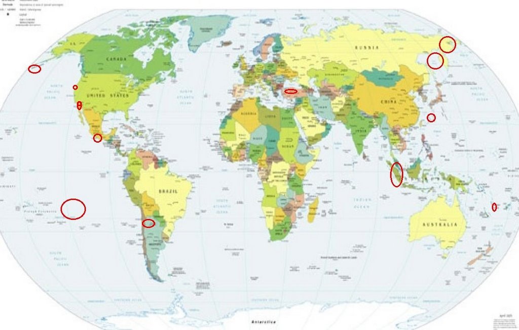
Places to watch.
Good luck to all.
For Wednesday, 27 September 2006.
---------------------------------------
RAT ISLANDS, ALEUTIAN ISLANDS,
ALASKA (51.434 179.447) (MEDIUM)
---------------------------------------
3.0 2006/09/27 14:26:49 52.616 -166.029 1.0 FOX ISLANDS, ALEUTIAN ISLANDS, ALASKA
3.0 2006/09/28 15:47:03 51.272 178.442 20.0 RAT ISLANDS, ALEUTIAN ISLANDS, ALASKA
Chile/Argentina border area (24.26S 67.00W)
(Possibly 2 different areas - MEDIUM)
---------------------------------------
2006-09-24 09:04:37.7 33.87S 72.29W 40 mb4.6 OFF COAST OF CENTRAL CHILE
2006-09-24 21:08:40.5 31.71S 67.14W 134 Mw5.7 SAN JUAN PROVINCE, ARGENTINA
2006-09-24 21:57:05.8 36.15S 70.12W 25 mb5.1 CHILE-ARGENTINA BORDER REGION
(2 days early)
Mt. San Gorgonio, CA (34.102 -116.924)
---------------------------------------
1.2 2006/09/26 05:03:55 34.072 -116.894 9.4 7 km(4 mi) WSW of Mt. San Gorgonio, CA
1.2 2006/09/26 06:24:52 34.008 -116.851 19.5 9 km ( 6 mi) NNE of Banning, CA
1.2 2006/09/26 09:23:59 33.996 -116.918 14.0 7 km ( 5 mi) NNW of Banning, CA
1.7 2006/09/26 17:06:14 33.935 -116.825 9.7 6 km ( 4 mi) WNW of Cabazon, CA
1.7 2006/09/26 20:53:13 34.019 -116.746 18.8 12 km(7 mi) SE of Mt. San Gorgonio, CA
1.0 2006/09/27 06:10:52 33.688 -116.750 17.7 7 km ( 5 mi) SSW of Idyllwild, CA
1.4 2006/09/27 05:53:43 33.889 -116.226 6.4 17 km(10 mi) ENE of Thousand Palms, CA
1.7 2006/09/27 05:52:03 33.892 -116.230 5.6 17 km(10 mi) ENE of Thousand Palms, CA
1.2 2006/09/27 05:39:15 33.887 -116.224 5.7 17 km(11 mi) ENE of Thousand Palms, CA
The Geysers
---------------------------------------
1.7 2006/09/26 00:09:21 38.833 -122.808 1.6 4 km ( 2 mi) N of The Geysers, CA
1.2 2006/09/26 22:01:25 38.805 -122.799 2.8 1 km ( 1 mi) NE of The Geysers, CA
2.0 2006/09/26 23:46:13 38.825 -122.794 2.1 3 km ( 2 mi) NNE of The Geysers, CA
2.0 2006/09/26 23:46:36 38.820 -122.794 2.4 3 km ( 2 mi) NNE of The Geysers, CA
1.7 2006/09/27 03:44:16 38.827 -122.872 1.3 7 km ( 4 mi) WNW of The Geysers, CA
1.2 2006/09/27 07:49:24 38.831 -122.804 2.3 4 km ( 2 mi) N of The Geysers, CA
1.5 2006/09/27 17:01:37 38.811 -122.801 1.3 2 km ( 1 mi) NNE of The Geysers, CA
2.5 2006/09/27 20:06:11 38.913 -123.225 2.1 22 km ( 14 mi) NW of Cloverdale, CA
2.6 2006/09/28 07:16:33 38.790 -122.775 0.8 3 km ( 2 mi) ESE of The Geysers, CA
1.1 2006/09/28 15:04:45 38.814 -122.804 8.7 2 km ( 1 mi) N of The Geysers, CA
1.1 2006/09/28 15:04:22 38.818 -122.792 3.1 3 km ( 2 mi) NNE of The Geysers, CA
2.4 2006/09/28 15:03:49 38.820 -122.790 2.3 3 km ( 2 mi) NNE of The Geysers, CA
1.5 2006/09/28 18:25:36 38.829 -122.807 0.8 3 km ( 2 mi) N of The Geysers, CA
2.1 2006/09/28 18:38:49 38.831 -122.807 1.9 4 km ( 2 mi) N of The Geysers, CA
Ryukyu Islands area (26.82N 127.68E)
(Second day symptom - this was different
kinds of vibrations and may be weather related
or something other than quaking.)
---------------------------------------
(Nothing found)
SEA OF OKHOTSK area (49.91N 146.82E)
(Strong)
---------------------------------------
2006-09-26 23:53:38 5.2 52.46N 148.58E 650 Sea of Okhotsk
2006-09-27 05:21:44.5 47.15N 142.52E 5 mb3.7 SAKHALIN ISLAND, RUSSIA
Sumatra
---------------------------------------
2006-09-27 15:09:26 4.9 4.32S 133.84E 20 Irian Jaya Region, Indonesia
COSTA GUERRERO-OAXACA area
(16.51 98.41) (Medium)
---------------------------------------
2006/09/27 03:06:11 18.74 108.20 10 4.1 374 km al SUROESTE de PUERTO VALLARTA, JAL(GS
2006/09/27 15:43:21 14.36 92.38 20 4.4 44 km al SUROESTE de CD HIDALGO, CHIS
2006/09/27 16:56:19 17.17 94.32 154 3.9 83 km al NOROESTE de CINTALAPA, CHIS
2006/09/27 17:54:48 16.34 99.36 8 4.1 50 km al SUR de SAN MARCOS, GRO
2006/09/27 18:22:44 16.47 99.35 20 4.4 36 km al SUR de SAN MARCOS, GRO
2006/09/27 18:42:50 16.44 99.34 16 4.0 40 km al SUR de SAN MARCOS, GRO
2006/09/28 00:07:32 17.83 98.71 57 3.8 34 km al NOROESTE de TLAPA, GRO
2006/09/28 01:54:22 16.52 99.39 18 3.8 31 km al SUR de SAN MARCOS, GRO
2006/09/28 03:58:22 16.43 99.37 16 3.8 40 km al SUR de SAN MARCOS, GRO
2006/09/28 14:24:27 16.06 99.24 16 4.1 83 km al SUR de SAN MARCOS, GRO
South Pacific Ocean area
(27.42S 125.67W)
---------------------------------------
2006-09-25 03:20:48 4.4 0.62S 124.98E 122 Southern Molucca Sea
2006-09-25 02:43:43 6.1 0.17S 125.07E 87 Southern Molucca Sea??
(2 days early and more north than expected)
Vanuatu
---------------------------------------
2006-09-25 07:46:31.3 6.12S 154.30E 65 M5.3 SOLOMON ISLANDS REGION
(2 days early)
2006-09-26 13:04:25 5.2 13.05S 164.87E 600 Vanuatu Islands Region
Ocotillo, CA area (32.528 -116.144)
---------------------------------------
1.4 2006/09/26 00:08:36 32.594 -116.157 12.9 22 km ( 14 mi) SW of Ocotillo, CA
1.2 2006/09/26 01:56:23 32.703 -116.043 7.7 6 km ( 4 mi) SW of Ocotillo, CA
1.3 2006/09/27 20:10:10 33.273 -116.137 8.6 14 km ( 9 mi) N of Ocotillo Wells, CA
1.3 2006/09/27 01:54:08 33.264 -116.120 2.1 13 km ( 8 mi) N of Ocotillo Wells, CA
1.7 2006/09/28 04:59:45 32.700 -116.053 6.4 7 km ( 4 mi) SW of Ocotillo, CA
1.6 2006/09/28 12:46:47 32.664 -116.104 5.9 13 km ( 8 mi) SW of Ocotillo, CA
1.6 2006/09/28 14:01:41 32.696 -116.039 3.0 6 km ( 4 mi) SW of Ocotillo, CA
2.1 2006/09/28 18:39:18 32.674 -115.856 9.3 15 km ( 9 mi) ESE of Ocotillo, CA
Turkey (Medium)
---------------------------------------
2006-09-27 08:45:34.0 37.87N 29.68E 11 MD2.9 TURKEY
2006-09-27 11:23:53.8 39.10N 33.30E 21 MD2.9 TURKEY
2006-09-27 19:05:39.7 38.00N 29.01E 4 MD3.3 TURKEY
Eastern Siberia (60.94N 165.29E)
(Strong)
---------------------------------------
25 Sep2006 16:38:48.4 60.0N 161.4E 50 MS=4.1 M GSR EASTERN SIBERIA, RUSSIA
(2 days early)
Peace to all.

posted by Unknown @ 2:18 PM
0 comments
![]()
![]()
