*For Tuesday, 3 October 2006.
LEGEND for OVERVIEW: Size = My surety of area for quake.
Red Circle = Probable quake to STRONG quake.
Triangle = Very Strong/Stronger quake (Usually takes extra days).
Blue Circle, etc. = Uncertainty of symptom area for probable quake.
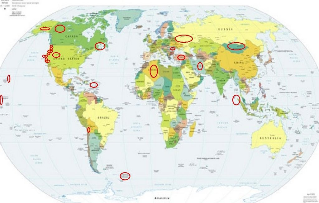
Places to watch.
Good luck to all.
For Tuesday, 3 October 2006.
---------------------------------------
Yukon/Northwest Territories
---------------------------------------
3.7 2006/10/02 00:43:32 65.455 -137.044 40.0 NORTHERN YUKON TERRITORY, CANADA
Parkfield Fault
---------------------------------------
1.4 2006/10/03 01:42:45 36.982 -121.633 5.6 6 km ( 4 mi) SW of Gilroy, CA
1.3 2006/10/03 07:47:52 35.934 -120.483 5.2 6 km ( 4 mi) NW of Parkfield, CA
1.0 2006/10/03 13:52:50 36.513 -121.061 6.3 8 km ( 5 mi) ESE of Pinnacles, CA
Puerto Rico/Virgin Islands (2 different
symptoms - STRONG)
---------------------------------------
3.5 2006/10/03 19:49:16 17.857N -68.843W 107.6 65 km (40 mi) SSE of La Romana, La Romana, Dominican Republic
2.7 2006/10/03 18:21:00 19.096N -66.796W 12.8 68 km (42 mi) N of Hatillo, PR
3.6 2006/10/03 18:10:19 19.343N -64.330W 75.8 68 km (42 mi) N of Settlement, Anegada, British Virgin Islands
Petrolia, California (Second day
symptom - Strong)
---------------------------------------
1.8 2006/10/03 08:35:08 40.374 -124.455 17.0 15 km ( 10 mi) WNW of Petrolia, CA
Mongolia area (Second day
symptom - Strong)
---------------------------------------
(Nothing found)
TARAPACA, CHILE area (19.23S 69.13W)
(Second day symptom - Strong)
---------------------------------------
2006-10-05 02:47:04 4.4 24.01S 67.27W 150 Chile-Argentina Border Region
(2 extra days)
San Francisco (MEDIUM)
---------------------------------------
1.4 2006/10/02 18:34:06 37.980 -122.471 0.1 5 km ( 3 mi) E of San Rafael, CA
1.5 2006/10/02 12:35:29 37.941 -121.792 14.0 6 km ( 4 mi) S of Antioch, CA
Redway, California area (40.278 -123.754)
---------------------------------------
1.5 2006/10/03 01:32:45 39.460 -123.107 5.5 14 km ( 9 mi) WNW of Lake Pillsbury, CA
1.8 2006/10/03 06:21:29 41.200 -122.478 5.0 17 km ( 11 mi) W of Dunsmuir, CA
Mt. St. Helen’s (Medium)
---------------------------------------
1.1 2006/10/03 03:10:42 46.204 -122.197 0.3 1 km ( 1 mi) WNW of Mount St. Helens Volcano, WA
2.3 2006/10/03 13:50:34 46.196 -122.194 0.5 1 km ( 1 mi) WSW of Mount St. Helens Volcano, WA
1.1 2006/10/03 15:03:17 46.199 -122.194 1.1 1 km ( 1 mi) W of Mount St. Helens Volcano, WA
1.8 2006/10/03 18:51:15 46.196 -122.195 0.0 1 km ( 1 mi) WSW of Mount St. Helens Volcano, WA
1.1 2006/10/03 21:12:51 46.198 -122.187 0.0 1 km ( 0 mi) WSW of Mount St. Helens Volcano, WA
Turkey (STRONG)
---------------------------------------
2006-10-02 22:20:27.8 38.24N 27.12E 5 MD3.3 TURKEY
2006-10-03 01:57:31.9 40.73N 33.07E 5 MD3.3 TURKEY
2006-10-03 02:28:40.3 39.34N 41.53E 29 MD2.8 TURKEY
2006-10-03 04:15:02.1 36.92N 35.75E 27 MD2.8 TURKEY
2006-10-03 06:41:15.1 40.22N 33.90E 18 MD2.9 TURKEY
2006-10-03 14:46:38.1 39.36N 27.74E 14 MD2.9 TURKEY
2006-10-03 21:36:05.9 37.86N 27.55E 32 MD2.9 TURKEY
2006-10-03 23:45:30.0 39.89N 40.04E 5 MD3.2 TURKEY
2006-10-03 23:38:02.8 39.04N 41.15E 9 MD2.9 TURKEY
2006-10-04 02:44:32.5 40.58N 33.03E 10 MD2.9 TURKEY
2006-10-04 07:35:07.5 38.67N 39.62E 23 MD3.1 TURKEY
2006-10-04 18:43:16.5 39.44N 33.43E 9 MD3.2 TURKEY
2006-10-04 18:09:52.7 41.18N 34.45E 5 MD3.6 TURKEY
Northwest Siberia area
---------------------------------------
BALTIC STATES-BELARUS-NW RUSSIA REGION
Origin time Lat Lon Azres Timres Wres Nphase Ntot Nsta Netmag
2006-276:09.39.20.0 68.03 60.00 8.64 0.32 2.48 3 3 3 2.37
BALTIC STATES-BELARUS-NW RUSSIA REGION
Origin time Lat Lon Azres Timres Wres Nphase Ntot Nsta Netmag
2006-276:11.19.38.0 62.47 54.61 8.00 0.16 2.16 2 2 1 2.47
NORTHWESTERN SIBERIA, RUSSIA
Origin time Lat Lon Azres Timres Wres Nphase Ntot Nsta Netmag
2006-276:12.38.27.0 70.70 70.34 16.32 3.68 7.76 3 4 2 3.27
Southern Alaska (Medium)
---------------------------------------
2.7 2006/10/03 23:45:16 60.379 -152.393 100.0 SOUTHERN ALASKA
Utah/Wyoming/Nevada (Strong)
---------------------------------------
1.6 2006/10/03 05:50:19 39.409 -111.224 6.4 24 km ( 15 mi) WNW of Huntington, UT
1.2 2006/10/03 13:33:04 39.722 -110.763 2.0 9 km ( 6 mi) ENE of Helper, UT
1.6 2006/10/03 16:28:53 39.416 -111.222 2.4 24 km ( 15 mi) WNW of Huntington, UT
1.6 2006/10/03 17:26:19 39.418 -111.226 3.1 24 km ( 15 mi) ESE of Spring City, UT
1.6 2006/10/03 19:25:23 39.417 -111.225 2.2 24 km ( 15 mi) ESE of Spring City, UT
1.9 2006/10/03 21:04:59 39.413 -111.227 7.1 24 km ( 15 mi) ESE of Spring City, UT
1.3 2006/10/03 23:07:03 39.749 -110.859 1.5 7 km ( 4 mi) N of Helper, UT
Scotts Mills, Oregon area (45.089 -122.618)
then
Roseburg, Oregon (43.266N 123.332W)
(These 2 symptoms may be for the same
area - Medium)
---------------------------------------
1.5 2006/10/04 14:26:02 44.172N 121.890W 10.8 30 km (19 mi) WSW of Sisters, OR
(Kind of hit in the middle.)
Samoa Islands area (14.21S 169.24W)
---------------------------------------
2006-10-02 18:44:03 5.3 16.43S 170.78W 10 Samoa Islands Region
Northcentral Iran
---------------------------------------
2006-10-04 17:57:09.7 35.67N 50.10E 5 M3.3 NORTHERN AND CENTRAL IRAN
SOUTH SANDWICH ISLANDS REGION
(59.24S 25.62W) (Strong)
---------------------------------------
(Nothing found)
Hawaii (2 different symptoms - Strong)
---------------------------------------
2.1 2006/10/03 00:34:13 19.386 -155.283 2.8 9 km ( 5 mi) SW of Volcano, HI
2.0 2006/10/03 02:16:34 19.329 -155.438 9.6 15 km ( 9 mi) NNE of Pahala, HI
1.9 2006/10/03 04:08:27 19.383 -155.251 1.6 8 km ( 5 mi) SSW of Volcano, HI
Baie-Comeau, QC area (49.12N 67.76W)
(Medium)
---------------------------------------
3.4 2006/10/03 00:07:37 44.329 -68.174 5.0 7 km ( 4 mi) SSE of Bar Harbor, ME
Boston.com
Quake causes falling rocks in Arcadia National Park, park road closed
October 2, 2006
BAR HARBOR, Maine --An earthquake caused some rocks to fall onto a road in Arcadia National Park and burst some water pipes Monday night. No injuries were reported, authorities said.
The quake reached a magnitude of 4.2 and was felt at about 8 p.m., said Jeff Chamberlain, dispatcher for the Bar Harbor Police Department. The department received notice from the U.S. Geological Survey about the quake, he said.
The park road was closed, Chamberlain said.
Mount Desert Island residents experienced a Magnitude 3.5 quake on Sept. 22. Before that, the state recorded a 3.8-Magnitude earthquake in the northern part of the state on July 14.
Northern Sumatra (STRONG)
---------------------------------------
2006-10-03 09:42:16.6 9.50N 93.14E 100 mb4.8 NICOBAR ISLANDS, INDIA, REG
Port Angeles, WA area (48.063N 123.219W)
---------------------------------------
2.4 2006/10/03 05:03:02 47.410 -122.516 51.4 4 km ( 2 mi) W of Vashon, WA
1.6 2006/10/03 00:35:17 48.248 -121.891 14.0 3 km ( 2 mi) SE of Oso, WA
(Not as far west as expected.)
Romania
---------------------------------------
2006-10-04 18:51:42.8 45.59N 26.38E 142 ML2.5 ROMANIA
Mammoth Lakes/Tom’s Place
---------------------------------------
1.2 2006/10/03 01:13:18 37.584 -118.874 3.6 11 km ( 7 mi) ESE of Mammoth Lakes, CA
1.5 2006/10/03 06:06:47 37.617 -118.958 5.0 3 km ( 2 mi) SE of Mammoth Lakes, CA
NORTHERN ALGERIA area (36.87N 3.85E)
---------------------------------------
2006-10-03 03:05:26.2 35.67N 4.59W 2 ML3.0 STRAIT OF GIBRALTAR
Peace to all.

posted by Unknown @ 2:06 PM
0 comments
![]()
![]()
