*For Monday, 12 June 2006.
LEGEND for OVERVIEW: Size = My surety of area for quake.
Red Circle = Probable quake to STRONG quake.
Triangle = Very Strong or Stronger quake (And usually takes extra days).
Blue Circle, etc. = Uncertainty of symptom area for probable quake.
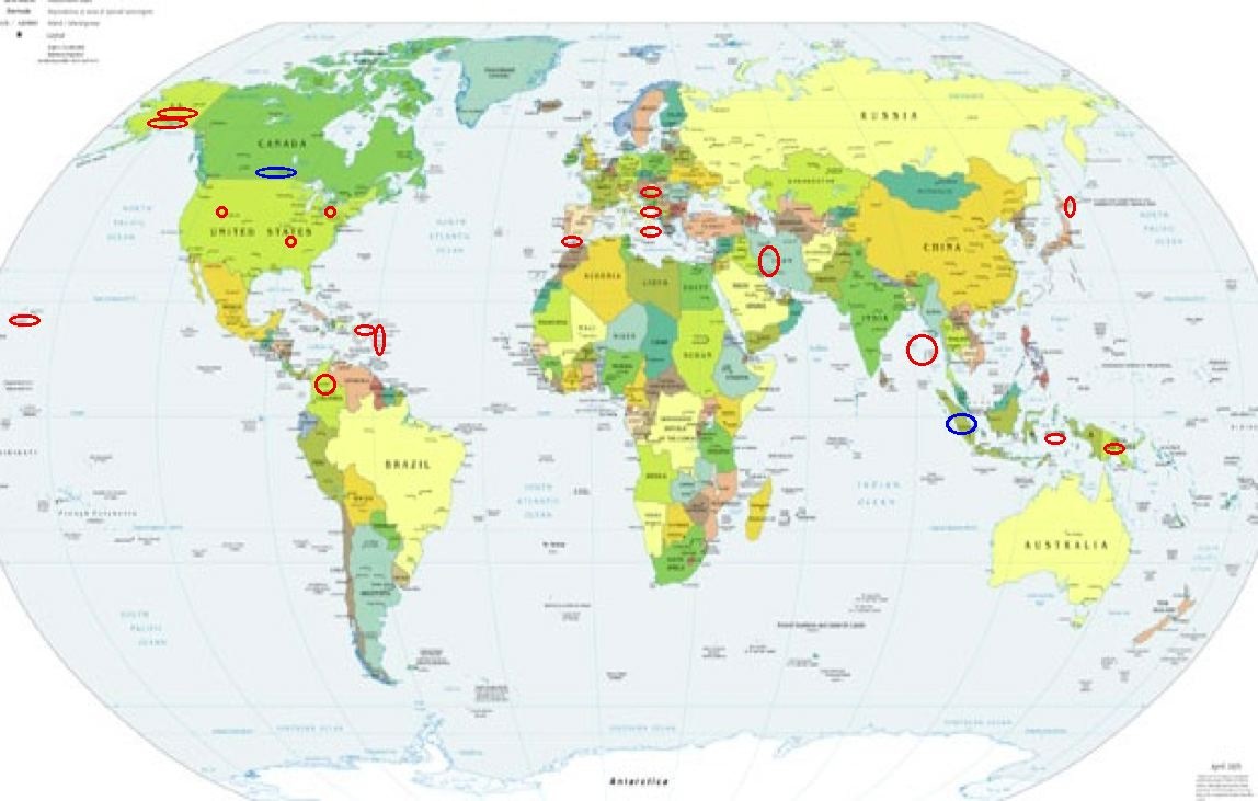
Places to watch.
Good luck to all.
For Monday, 12 June 2006.
----------------------------------------
Hokkaido area (Strong)
----------------------------------------
2006-06-11 23:04:19.5 41.51 N 142.06 E 90 mb 4.7 HOKKAIDO, JAPAN, REGION
2006-06-13 02:40:32 5.2 42.85 N 143.29 E Hokkaido, Japan Region
Southern Alaska and then Alaska Peninsula (Medium for Alaska Peninsula)
----------------------------------------
MAP 2.7 2006/06/12 07:06:53 54.265 -163.669 50.0 UNIMAK ISLAND REGION, ALASKA
MAP 2.7 2006/06/12 05:54:00 58.751 -152.989 70.0 KODIAK ISLAND REGION, ALASKA
Nicobar/Andaman Islands are then possibly Sumatra
----------------------------------------
(Symptoms felt for 12, 13 and 14 June and posted on 14th.)
Northern Colombia (6.75 N 72.96 W)
----------------------------------------
2006-06-18 04:59:00.5 4.66 N 72.95 W 62 mb 4.5 COLOMBIA
2006-06-18 04:59:00.0 4.66 N 72.95 W 39 M 4.6 COLOMBIA
(6 extra days)
Western Iran (Medium)
----------------------------------------
(Nothing found)
Volcano, Hawaii (19.384 -155.281)
----------------------------------------
MAP 1.9 2006/06/11 09:31:54 19.395 -155.301 4.1 9 km ( 6 mi) SW of Volcano, HI
MAP 1.8 2006/06/11 10:15:34 19.428 -155.875 4.7 2 km ( 1 mi) SE of Honaunau-Napoopoo, HI
MAP 2.2 2006/06/11 12:11:24 19.390 -155.281 3.0 8 km ( 5 mi) SW of Volcano, HI
MAP 2.9 2006/06/12 12:11:49 19.366 -155.171 32.2 11 km ( 7 mi) SE of Volcano, HI
Strait of Gibraltar
----------------------------------------
2006-06-12 08:44:56.8 35.77 N 9.75 W mb 2.9 WEST OF GIBRALTAR
The New Madrid Fault/Missouri area (36.570 -89.620) (Second day
symptoms and stronger - STRONG)
----------------------------------------
(Nothing found)
Sicily, Italy/Ionian Sea then Adriatic Sea area
----------------------------------------
2006-06-12 21:18:35.0 41.91 N 15.75 E 4 ML 2.6 SOUTHERN ITALY
2006-06-12 21:18:32.0 42.06 N 15.81 E 3 ML 2.8 ADRIATIC SEA
Banda Sea area ( 4.20 S 128.84 E) (Strong)
----------------------------------------
2006-06-12 15:56:42 4.8 8.28 S 120.71 E Flores Region, Indonesia
Utah (Medium)
----------------------------------------
MAP 1.1 2006/06/12 03:41:34 41.660 -112.035 1.6 5 km ( 3 mi) NE of Honeyville, UT
MAP 1.6 2006/06/12 04:44:48 39.609 -110.390 1.2 6 km ( 4 mi) N of Sunnyside, UT
MAP 1.9 2006/06/12 07:23:12 38.307 -112.226 3.4 8 km ( 5 mi) N of Junction, UT
MAP 1.7 2006/06/12 12:01:52 41.920 -112.557 4.3 14 km ( 9 mi) ESE of Snowville, UT
MAP 1.4 2006/06/12 15:57:34 39.611 -110.394 1.2 7 km ( 4 mi) N of Sunnyside, UT
MAP 1.7 2006/06/12 20:11:57 41.149 -112.922 4.5 67 km ( 42 mi) W of Hooper, UT
Czech and Slovak Republics area (49.92 N 18.58 E) (Medium)
----------------------------------------
2006-06-18 16:20:39.9 49.77 N 18.25 E 3 ML 2.3 CZECH AND SLOVAK REPUBLICS
(6 extra days)
Eastern New Guinea, P.N.G. (5.56S 146.94E) (Second day for symptoms - Strong)
----------------------------------------
(Nothing found)
The Virgin Islands area and then Puerto Rico area (Strong for both areas)
----------------------------------------
MAP 4.9 2006/06/11 00:24:31 14.169 -58.405 10.0 NORTHEAST OF BARBADOS, WINDWARD ISLANDS
MAP 3.6 2006/06/12 07:31:15 19.553 -65.333 72.4 136 km ( 84 mi) NNE of Vieques, PR
MAP 1.7 2006/06/12 20:11:57 41.149 -112.922 4.5 67 km ( 42 mi) W of Hooper, UT
MAP 2.6 2006/06/12 11:31:12 18.912 -66.364 24.8 49 km ( 31 mi) N of Breñas, PR
MAP 2.0 2006/06/12 23:45:27 18.011 -67.088 8.1 5 km ( 3 mi) ESE of Betances, PR
Possibly Southcentral Canada area (New symptom)
----------------------------------------
2006/06/12 13:45:24 74.61N 92.80W 18.0* 1.7MN 61 km E from Resolute,NU
2006/06/13 05:39:28 64.95N 88.51W 18.0* 1.5MN 205 km SW from Repulse Bay,NU
(Possible but way further North than expected.)
South Shore Lake Erie (41.87N 80.87W)
----------------------------------------
(A New York quake on the 13th and posted there.)
Peace to all.

posted by Unknown @ 3:09 PM
0 comments
![]()
![]()
