*For Saturday, 4 November 2006.
LEGEND for OVERVIEW: Size = My surety of area for quake.
Red Circle = Probable quake to STRONG quake.
Triangle = Very Strong/Stronger quake (Usually takes extra days).
Blue Circle, etc. = Uncertainty of symptom area for probable quake.
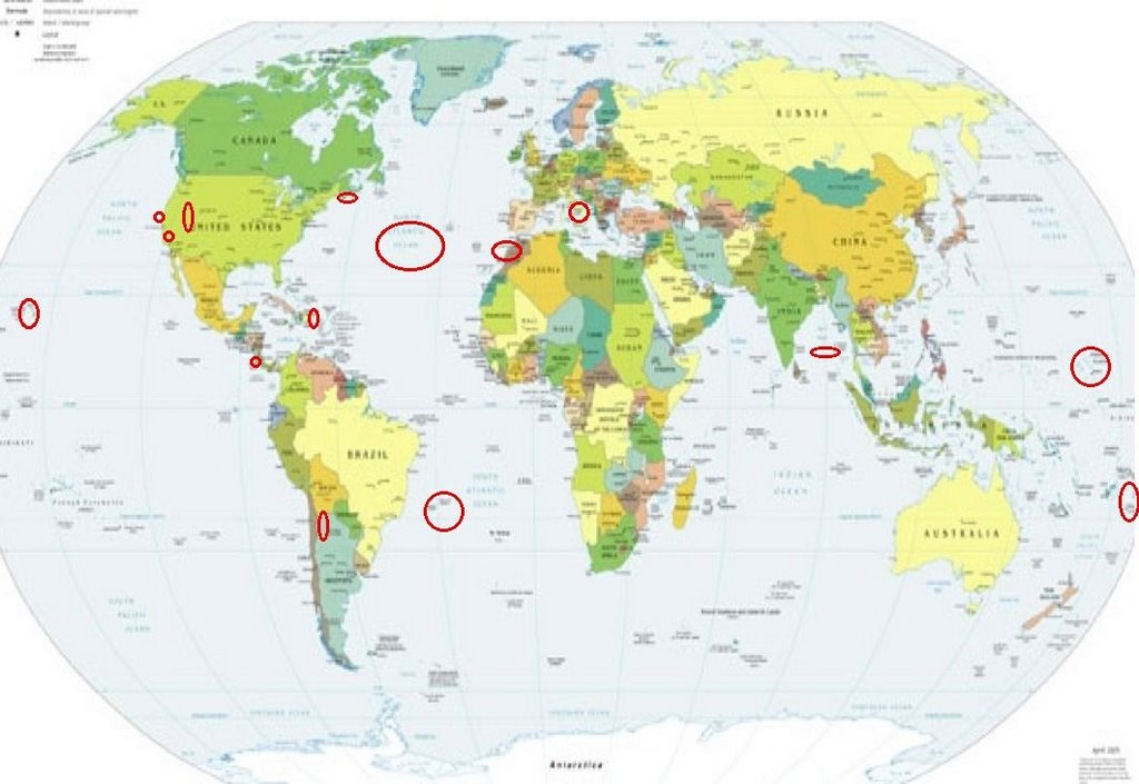
Places to watch.
Good luck to all.
For Saturday, 4 November 2006.
--------------------------------------
NORTHERN MID-ATLANTIC RIDGE area
(30.39N 41.93W)
--------------------------------------
2006-11-04 19:25:16.0 37.75N 25.32W ML2.8 AZORES ISLANDS, PORTUGAL
2006-11-04 19:18:33.0 37.73N 25.32W ML2.9 AZORES ISLANDS, PORTUGAL
2006-11-04 19:05:24.0 37.75N 25.35W 3 ML2.2 AZORES ISLANDS, PORTUGAL
2006-11-04 19:02:30.0 37.73N 25.32W 1 ML3.1 AZORES ISLANDS, PORTUGAL
2006-11-04 05:54:29.0 38.45N 26.90W ML3.1 AZORES ISLANDS, PORTUGAL
2006-11-04 05:49:23.0 38.43N 26.90W 3 ML3.3 AZORES ISLANDS, PORTUGAL
(Off on coordinates)
2006-11-05 09:59:29.7 40.25N 29.77W 33 mb4.9 AZORES ISLANDS REGION
Hawaii
--------------------------------------
2.7 2006/11/04 00:38:42 19.848 -156.018 17.5 14 km ( 9 mi) N of Kalaoa, HI
2.4 2006/11/04 00:55:17 19.476 -154.883 1.3 4 km ( 2 mi) E of Leilani Estates, HI
2.2 2006/11/04 04:26:05 19.169 -155.532 31.1 7 km ( 4 mi) SW of Pahala, HI
2.5 2006/11/04 17:36:30 19.995 -156.144 17.7 30 km ( 19 mi) WNW of Puako, HI
Higüey, La Altagracia, Dominican Republic
(19.054N -68.606W)
--------------------------------------
1.9 2006/11/04 23:12:05 18.067N -67.175W 24.9 2 km ( 1 mi) SE of Puerto Real, PR
2.8 2006/11/04 15:07:49 18.778N -66.509W 121.4 35 km (22 mi) N of Tierras Nuevas Poniente, PR
2.9 2006/11/04 14:50:31 19.299N -66.624W 25.9 92 km (57 mi) N of Carrizales, PR
3.3 2006/11/04 13:23:16 19.219N -66.573W 25.3 85 km (53 mi) N of Tierras Nuevas Poniente, PR
2.3 2006/11/04 03:20:31 18.043N -67.073W 21.4 0 km ( 0 mi) NNE of Palmarejo, PR
(Not Dominican Republic)
Andaman Islands (11.54N 95.10E)
(Indication of depth - STRONG)
--------------------------------------
(Nothing found)
Costa Rica area (11.35N 85.52W)
--------------------------------------
06/11/03 20:54:24 10.90N 83.15W 1.0 3.2ML Sismo regional o lejano
06/11/03 17:11:21 11.32N 87.00W 4.4 3.1ML Frente a Masachapa
06/11/03 09:44:41 12.25N 86.78W 103.2 2.7ML León
06/11/04 23:20:49 12.98N 88.51W 2.6 4.9ML Frente a El Salvador
06/11/04 07:36:28 11.60N 87.19W 9.3 2.8ML Frente a Puerto Sandino
06/11/04 05:02:04 12.47N 87.76W 101.7 2.2ML Frente al Cosigüina
06/11/04 01:59:18 12.39N 87.99W 1.0 3.0ML Frente al Cosigüina
06/11/04 01:58:25 13.01N 87.63W 1.0 1.9ML Cerca del volcan Cosigüina
06/11/04 01:57:16 11.83N 87.86W 72.9 2.7ML Oceano Pacífico de Nicaragua
06/11/05 23:00:23 12.00N 86.96W 67.7 2.8ML Frente a Puerto Sandino
06/11/05 13:00:32 11.78N 87.07W 34.7 2.5ML Frente a Puerto Sandino
06/11/05 02:55:28 12.20N 87.19W 163.3 2.9MC Frente a Poneloya
(More North than expected.)
Tonga
--------------------------------------
(Nothing found)
Utah/Nevada
--------------------------------------
06/11/04 02:44:06 39.42N 111.23W 3.3 1.5 15.2 mi E of Spring City
06/11/04 11:26:03 40.40N 109.87W 7.7 1.4 8.9 mi E of Neola
06/11/04 16:02:14 39.42N 111.22W 2.4 1.4 15.2 mi E of Spring City
06/11/04 17:32:56 39.41N 111.23W 6.1 1.5 15.2 mi E of Spring City
06/11/04 18:13:32 39.41N 111.22W 5.0 1.5 15.1 mi WNW of Huntington
06/11/04 19:22:02 39.67N 110.48W 4.6 1.8 9.3 mi NNW of E. Carbon City
06/11/04 19:46:08 39.41N 111.23W 5.2 1.7 15.1 mi E of Spring City
06/11/04 21:17:07 39.41N 111.23W 4.7 1.9 15.2 mi E of Spring City
06/11/04 23:53:11 39.42N 111.23W 2.1 1.6 15.2 mi E of Spring City
06/11/05 00:19:44 37.25N 112.83W 1.6 1.5 10.6 mi WSW of Orderville
06/11/05 00:43:54 37.25N 112.83W 2.9 1.1 10.9 mi WSW of Orderville
06/11/05 16:07:38 39.42N 111.22W 2.3 1.5 15.1 mi WNW of Huntington
06/11/05 16:32:48 39.42N 111.23W 2.0 1.9 15.1 mi E of Spring City
06/11/05 21:00:36 39.42N 111.22W 2.4 1.6 15.1 mi WNW of Huntington
06/11/05 22:43:44 39.42N 111.22W 2.2 1.6 15.2 mi WNW of Huntington
06/11/05 22:54:08 39.67N 110.48W 4.0 1.3 9.2 mi NW of E. Carbon City
06/11/05 23:04:48 39.41N 111.21W 2.9 1.3 14.5 mi WNW of Huntington
Saint John, NB area (45.42N 66.48W)
--------------------------------------
2006/11/03 07:51:40 49.27N 67.51W 18.0* 1.8MN 47 km N from Matane,QC
2006/11/03 03:29:13 50.33N 65.26W 18.0* 1.7MN 27 km W from Sheldrake,QC
2006/11/04 11:42:07 43.77N 77.95W 5.0* 2.2MN 28 km SE from Cobourg,ON
2006/11/04 04:50:03 44.37N 68.14W 5.0* 1.8MN Maine,near Bar Harbor
2006/11/04 04:22:41 44.36N 68.14W 5.0* 1.9MN Maine,near Bar Harbor
Mammoth Lakes/Tom’s PLace (Strong)
--------------------------------------
1.9 2006/11/05 22:33:55 37.516 -118.826 8.4 14 km ( 9 mi) WSW of Toms Place, CA
1.9 2006/11/05 22:30:54 37.519 -118.828 9.3 14 km ( 9 mi) WSW of Toms Place, CA
1.4 2006/11/06 12:19:04 37.483 -118.844 9.5 17 km ( 11 mi) WSW of Toms Place, CA
(2 extra days)
1.0 2006/11/07 02:59:56 37.655 -118.936 6.7 4 km ( 3 mi) ENE of Mammoth Lakes, CA
1.0 2006/11/07 02:57:44 37.661 -118.936 6.9 5 km ( 3 mi) NE of Mammoth Lakes, CA
(3 extra days)
South Atlantic Ocean (33.49S 44.05W)
--------------------------------------
2006-11-05 10:05:15.8 2.16S 25.77W 33 mb5.1 SOUTH ATLANTIC OCEAN
(Not as far south as expected.)
San Rafael area/North of San Francisco
--------------------------------------
(Nothing found)
Chile/Argentina border area
(24.26S 67.00W)
--------------------------------------
04Nov2006 18:54:31.5 19.5S 69.6W100 mb=5.3 M*GSR NORTHERN CHILE
2006-11-06 14:51:34 5.3 26.64S 70.65W 20 Near Coast of Northern Chile
(2 extra days
Central Italy (43.80N 11.95E)
--------------------------------------
2006-11-04 10:04:17.0 41.99N 13.06E 7 ML2.4 SOUTHERN ITALY
2006-11-05 16:57:35.0 42.74N 12.75E 6 ML2.6 CENTRAL ITALY
2006-11-05 20:45:05.0 37.68N 15.09E 4 ML2.1 SICILY, ITALY
Morocco
--------------------------------------
2006-11-04 04:35:27.1 34.99N 3.89W mb3.6 MOROCCO
MARIANA ISLANDS REGION (21.13N 143.09E)
--------------------------------------
2006-11-03 02:30:24 5.6 18.01N 145.59E 234 Mariana Islands
2006-11-03 02:29:48 5.9 19.12N 147.24E 20 Mariana Islands Region
Peace to all.

posted by Unknown @ 1:24 PM
0 comments
![]()
![]()
