*For Tuesday, 7 February 2006.
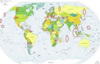
LEGEND for OVERVIEW:
Size = My surety of area for quake.
Red Circle = Probable quake to STRONG quake.
Triangle = Very Strong or Stronger quake (And usually takes extra days).
Blue Circle, etc. = Uncertainty of symptom area for probable quake.

Places to watch.
Good luck to all.
For Tuesday, 7 February 2006.
----------------------------------------
Rat Islands, Aleutians (51.434 179.447) (2 different symptoms - STRONG)
----------------------------------------
MAP 5.1 2006/02/07 11:50:06 48.275 156.623 36.9 EAST OF THE KURIL ISLANDS
North Ural Mountains to Novaya Zemlya area (STRONG)
----------------------------------------
URAL MOUNTAINS, RUSSIA, REGION
Origin time Lat Lon Azres Timres Wres Nphase Ntot Nsta Netmag
2006-037:20.59.02.0 68.62 66.42 16.45 7.89 12.01 3 3 2 2.61
NOVAYA ZEMLYA, RUSSIA
Origin time Lat Lon Azres Timres Wres Nphase Ntot Nsta Netmag
2006-037:20.43.52.0 75.12 57.09 13.35 0.05 3.39 2 2 1 2.26
NOVAYA ZEMLYA, RUSSIA
Origin time Lat Lon Azres Timres Wres Nphase Ntot Nsta Netmag
2006-038:02.08.23.0 76.14 60.91 13.15 0.08 3.37 2 2 1 2.61
NOVAYA ZEMLYA, RUSSIA
Origin time Lat Lon Azres Timres Wres Nphase Ntot Nsta Netmag
2006-038:09.34.41.0 70.58 52.58 5.38 3.12 4.46 3 3 2 2.20
Mid-Indian Ridge area (24.34S 70.27E)
----------------------------------------
2006-02-06 18:49:28.7 19.77S 38.63E 10 mb4.9 MOZAMBIQUE CHANNEL
Pyrenees area (42.34N 1.41E) (MEDIUM)
----------------------------------------
2006-02-07 12:58:32.8 47.19N 3.66E 2 ML2.5 FRANCE
2006-02-07 14:59:19.5 42.49N 1.76E 1 ML3.6 PYRENEES
2006-02-07 16:38:12.9 43.04N 6.35E 2 ML2.6 NEAR SOUTH COAST OF FRANCE
Kamchatka/Sakhalin and North of (Second day symptom - STRONG)
----------------------------------------
2006-02-08 13:28:54.8 51.90N 160.02E 40 Ms3.4 OFF E. CST KAMCHATKA PEN.
Pinnacles/Parkfield and in between (Strong)
----------------------------------------
MAP 2.6 2006/02/07 06:04:38 36.541 -121.093 1.9 5 km ( 3 mi) ENE of Pinnacles, CA
Utah/Nevada (3 different symptoms - STRONG)
----------------------------------------
map 1.3 2006/02/07 23:00:45 39.415N 111.220W 5.0 24 km (15 mi) WNW of Huntington, UT
map 1.4 2006/02/07 20:41:14 39.411N 111.220W 6.3 24 km (15 mi) WNW of Huntington, UT
map 1.6 2006/02/07 17:41:40 39.410N 111.225W 5.5 24 km (15 mi) WNW of Huntington, UT
map 1.7 2006/02/07 16:56:03 39.408N 111.928W 2.5 18 km (11 mi) SSW of Levan, UT
map 0.5 2006/02/07 16:55:52 39.398N 111.173W 15.0 20 km (12 mi) WNW of Huntington, UT
map 1.7 2006/02/07 15:46:53 39.727N 110.807W 0.1 6 km ( 4 mi) NE of Helper, UT
map 1.6 2006/02/07 15:14:13 39.408N 111.216W 2.1 23 km (15 mi) WNW of Huntington, UT
map 1.3 2006/02/07 15:05:26 38.956N 112.952W 4.5 48 km (30 mi) SSW of Hinckley, UT
map 1.6 2006/02/07 14:58:44 39.410N 111.219W 2.4 24 km (15 mi) WNW of Huntington, UT
map 1.6 2006/02/07 14:20:29 39.408N 111.218W 2.1 24 km (15 mi) WNW of Huntington, UT
map 1.3 2006/02/07 13:55:46 39.185N 111.212W 6.7 12 km ( 8 mi) NW of Ferron, UT
map 1.6 2006/02/07 12:52:04 39.411N 111.216W 2.3 24 km (15 mi) WNW of Huntington, UT
map 1.5 2006/02/07 12:13:48 39.411N 111.224W 4.8 24 km (15 mi) WNW of Huntington, UT
map 1.3 2006/02/07 11:55:21 39.706N 110.740W 0.8 10 km ( 6 mi) ENE of Helper, UT
map 1.4 2006/02/07 11:36:44 39.412N 111.223W 4.1 24 km (15 mi) WNW of Huntington, UT
map 1.5 2006/02/07 09:47:45 39.412N 111.222W 4.8 24 km (15 mi) WNW of Huntington, UT
map 1.4 2006/02/07 08:24:37 39.411N 111.222W 6.1 24 km (15 mi) WNW of Huntington, UT
map 1.4 2006/02/07 08:07:39 39.669N 110.523W 2.4 16 km (10 mi) NW of E. Carbon City, UT
map 1.3 2006/02/07 08:05:42 39.413N 111.222W 5.0 24 km (15 mi) WNW of Huntington, UT
map 2.4 2006/02/08 12:32:39 38.218N 112.590W 0.2 8 km ( 5 mi) SE of Beaver, UT
map 2.1 2006/02/08 22:09:09 40.560N 111.969W 12.3 5 km ( 3 mi) NNW of Riverton, UT
Central/Southern Italy then Northern Italy to Austria and Czech Republic (STRONG for Central/Southern Italy)
----------------------------------------
HUNGARY
Origin time Lat Lon Azres Timres Wres Nphase Ntot Nsta Netmag
2006-038:09.28.09.0 46.48 19.65 3.15 0.05 0.84 2 2 1 2.91
(Nothing found for Central/Southern Italy or Northern Italy)
Hawaii and South of (2 different symptoms - MEDIUM)
----------------------------------------
MAP 1.7 2006/02/07 00:10:00 19.403 -155.259 1.4 6 km ( 4 mi) SSW of Volcano, HI
MAP 2.2 2006/02/07 00:42:01 19.385 -155.241 3.7 7 km ( 4 mi) S of Volcano, HI
MAP 1.9 2006/02/07 00:44:11 19.385 -155.243 3.0 7 km ( 4 mi) S of Volcano, HI
Mariana Islands (Volcanic)
----------------------------------------
(Nothing found)
Possibly North Pacific (179W 30N)
----------------------------------------
(Nothing found)
Possibly Salta Province, Argentina (24.02S 66.61W) (Unproven symptom)
----------------------------------------
2006-02-08 13:57:47.3 28.64S 67.57W 100 mb 4.5 LA RIOJA PROVINCE, ARGENTINA
South Coast of Oregon
----------------------------------------
MAP 1.9 2006/02/06 22:10:36 40.515 -124.083 18.3 3 km ( 2 mi) NE of Rio Dell, CA
map 2.6 2006/02/06 18:52:57 40.506 -124.692 22.9 37 km ( 23 mi) WSW of Ferndale, CA
Sumatra and other parts of Indonesia (Strong - strange up and down symptom)
----------------------------------------
06Feb2006 07:05:01.0 2.3N 96.5E 33 MS=5.0 M*GSR NORTHERN SUMATERA, INDONES1016
06Feb2006 12:40:42.0 2.7N 96.0E 33 mb=5.1 M*GSR NORTHERN SUMATERA, INDONES1358
2006-02-06 23:55:10.7 1.75N 97.29E 33 Mw 5.3 NORTHERN SUMATERA, INDONESIA
Yukon Territories/Northwest Territories
----------------------------------------
MAP 4.4 2006/02/07 11:08:58 66.265 -140.886 15.0 NORTHERN YUKON TERRITORY, CANADA
MAP 4.4 2006/02/07 11:08:54 67.172 -140.936 15.0 NORTHERN YUKON TERRITORY, CANADA
Peace to all.

