*For Saturday, 26 November 2005.
Places to watch.
Good luck to all.
For Saturday, 26 November 2005.
----------------------------------------
Off the Coast of Northern California area (STRONG)
----------------------------------------
MAP 3.1 2005/11/26 07:02:28 40.334 -124.338 17.4 5 km ( 3 mi) WNW of Petrolia, CA
Switzerland/Northern Italy area
----------------------------------------
2005/11/26 23:20:00.5 44.45 N 7.00 E 2 ML2.4 NORTHERN ITALY
Possibly Klamath Falls, Oregon (New symptom)
----------------------------------------
map 1.8 2005/11/26 09:39:33 47.900N 122.060W 26.0 3 km ( 2 mi) ESE of Snohomish, WA
South Atlantic near Ascension
----------------------------------------
(Nothing found)
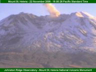
Mt. St. Helen's (Volcanic eruption Friday or Saturday - Medium)
----------------------------------------
Tuesday, November 22, 2005 10:55 a.m. PST (1855 UTC)
MOUNT ST. HELENS UPDATE
Current status is Volcano Advisory (Alert Level 2); aviation color code ORANGE: Growth of the new lava dome inside the crater of Mount St. Helens continues, accompanied by low rates of seismicity, low emissions of steam and volcanic gases, and minor production of ash. During such eruptions, changes in the level of activity can occur over days to months. The eruption could intensify suddenly or with little warning and produce explosions that cause hazardous conditions within several miles of the crater and farther downwind. Small lahars could suddenly descend the Toutle River if triggered by heavy rain or by interaction of hot rocks with snow and ice. These lahars pose a negligible hazard below the Sediment Retention Structure (SRS) but could pose a hazard along the river channel upstream.
USGS
(The volcano made national news today because of a dislodged rock which caused a cloud over the crater on the 22nd.)

----------------------------------------
map 2.3 2005/11/25 03:08:02 46.199N 122.190W 0.0 0 km ( 0 mi) ENE of Mount St. Helens
MAP 3.0 2005/11/26 09:11:04 46.196 -122.191 0.1 1 km ( 1 mi) WSW of Mount St. Helens Volcano, WA
Southeastern Siberia (57.66N 120.83E) to Lake Baykal, Russia (STRONG)
----------------------------------------
2005/11/25 05:30:05.0 56.28 N 66.17 E ML3.6 SOUTHWESTERN SIBERIA, RUSSIA
2005/11/26 13:13:59.7 57.64 N 120.39 E 10 Ms3.4 SOUTHEASTERN SIBERIA, RUSSIA
Finland area (Continuous light bubbles that probably signify micro quakes in abundance.)
----------------------------------------
SOUTHERN BOTHNIA FINLAND
Origin time Lat Lon Azres Timres Wres Nphase Ntot Nsta Netmag
2005-325:12.29.25.0 61.70 23.11 1.90 0.61 1.08 2 2 1 1.76
Ecuador/Colombia area
----------------------------------------
(Nothing found)
Santa Rosa, California (STRONG)
map 2.7 2005/11/23 14:46:26 38.475 -122.731 6.1 4 km ( 2 mi) NW of Santa Rosa, CA
(This already started as I type on the 23d of November.)
----------------------------------------
map 2.1 2005/11/24 21:27:04 38.573 -122.788 6.0 3 km ( 2 mi) NNE of Windsor, CA
(Nothing found since these 2 small quakes - may be more coming.)
Kazakhstan to Kyrgyzstan
----------------------------------------
2005/11/24 09:38:46.0 50.40 N 71.42 E ML3.1 CENTRAL KAZAKHSTAN
(2 days early)
2005/11/26 13:09:51.0 41.83 N 73.05 E ML3.4 KYRGYZSTAN
Ukiah area and West of (Medium)
----------------------------------------
MAP 3.0 2005/11/24 16:10:44 39.160 -123.150 9.6 3 km ( 2 mi) NNE of Talmage, CA
(2 days early)
Barents Sea area (Medium)
----------------------------------------
BARENTS SEA
Origin time Lat Lon Azres Timres Wres Nphase Ntot Nsta Netmag
2005-325:00.47.34.0 77.80 38.33 6.10 0.71 2.24 3 4 2 2.15
BARENTS SEA
Origin time Lat Lon Azres Timres Wres Nphase Ntot Nsta Netmag
2005-325:06.16.11.0 77.34 61.87 20.28 0.52 5.59 3 4 2 2.04
BARENTS SEA
Origin time Lat Lon Azres Timres Wres Nphase Ntot Nsta Netmag
2005-325:19.01.09.0 76.37 41.39 11.27 1.13 3.95 3 4 3 2.32
WESTERN BARENTS SEA
Origin time Lat Lon Azres Timres Wres Nphase Ntot Nsta Netmag
2005-325:19.30.55.0 76.06 18.28 13.50 1.13 4.51 3 3 3 2.16
Japan/possibly as far north as Hokkaido (STRONG)
----------------------------------------
2005/11/27 02:13:15.5 27.14 N 140.16 E 407 mb4.9 BONIN ISLANDS, JAPAN, REGION
Northern Iran (Medium)
----------------------------------------
2005/11/26 06:12:52.0 29.17 N 51.38 E 23 M 3.3 SOUTHERN IRAN
(Not Northern)
Peace to all.

