*For Sunday, 7 May 2006.
LEGEND for OVERVIEW: Size = My surety of area for quake.
Red Circle = Probable quake to STRONG quake.
Triangle = Very Strong or Stronger quake (And usually takes extra days).
Blue Circle, etc. = Uncertainty of symptom area for probable quake.
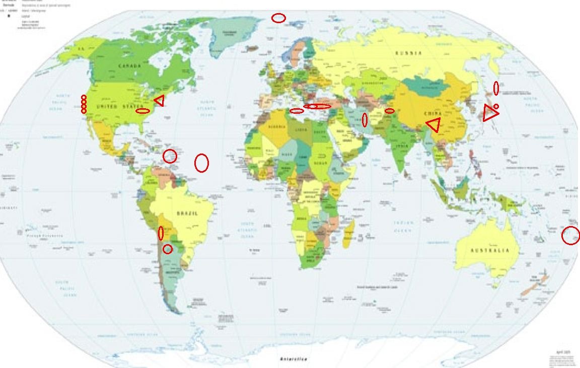
Places to watch.
Good luck to all.
For Sunday, 7 May 2006.
----------------------------------------
Chile/Bolivia border area (21.19S 68.41) (Second day of symptom - Strong)
----------------------------------------
(Nothing found)
Puerto Rico/The Virgin Islands area then into the Central North Atlantic some
----------------------------------------
MAP 2.9 2006/05/07 07:22:21 18.702 -67.397 14.2 39 km ( 24 mi) NW of Aguadilla, PR
MAP 3.5 2006/05/07 10:02:51 19.171 -64.436 18.4 51 km ( 31 mi) NNW of Settlement, British Virgin Islands
MAP 2.9 2006/05/07 10:13:04 18.997 -67.802 7.2 93 km ( 58 mi) NW of Aguadilla, PR
MAP 3.4 2006/05/07 16:54:02 17.963 -68.473 83.5 74 km ( 46 mi) SE of La Romana, Dominican Republic
MAP 4.8 2006/05/08 04:54:44 35.305 -36.332 10.0 NORTHERN MID-ATLANTIC RIDGE
The Parkfield Fault at the center
----------------------------------------
MAP 2.3 2006/05/07 02:45:32 36.032 -120.595 7.7 21 km ( 13 mi) NW of Parkfield, CA
MAP 1.3 2006/05/07 04:27:40 36.536 -121.114 2.7 3 km ( 2 mi) E of Pinnacles, CA
MAP 2.5 2006/05/07 08:55:16 36.045 -120.611 9.5 23 km ( 14 mi) NW of Parkfield, CA
MAP 2.0 2006/05/07 23:55:37 37.864 -121.975 11.3 4 km ( 2 mi) NNW of Diablo, CA
(Not center yet)
Honshu, Japan and North of (EXTREMELY STRONG - may take extra days)
http://www.cdli.ca/CITE/japan.htm>cdli
http://www.japan-guide.com/a/>japan-guide

----------------------------------------
2006-05-07 11:09:30.1 26.89 N 130.30 E 2 mb 5.1 SE. OF RYUKYU ISLANDS, JAPAN
(South of)
Kuril Islands and North of
----------------------------------------
2006-05-06 19:47:34.6 44.05 N 148.24 E 59 mb 4.8 KURIL ISLANDS, RUSSIA
Xizang, China area (32.3N 95.1E) then North of (Indication of depth) (Very Strong)
http://www.planetware.com/picture/tibet-xizang-xijang-chn-chn677.htm>planetware
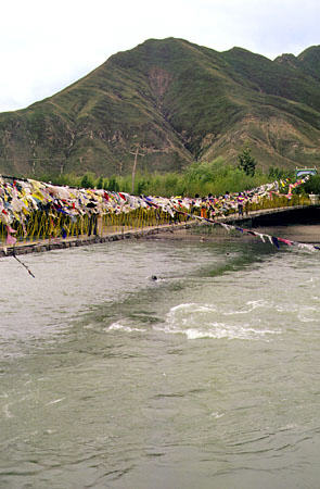
----------------------------------------
2006-05-07 03:43:10.0 41.89 N 82.81 E ML 3.8 SOUTHERN XINJIANG, CHINA
Greece/Turkey area then Aegean Sea (Strong for Aegean Sea)
----------------------------------------
2006-05-07 06:18:16.3 37.21 N 34.78 E 15 MD 3.2 TURKEY
2006-05-07 05:43:29.2 38.21 N 26.68 E 20 MD 3.4 AEGEAN SEA
2006-05-07 14:21:49.6 38.79 N 26.91 E 40 ML 3.1 AEGEAN SEA
Jujuy Province, Argentina area (23.53S 66.46W) (MEDIUM)
----------------------------------------
2006-05-09 09:02:22.4 32.40 S 69.48 W 100 mb 5.2 MENDOZA PROVINCE, ARGENTINA
(2 extra days - not really close to this area or Chile-Bolivia area.)
Mohn’s Ridge area (71.89 -1.91) (Medium)
----------------------------------------
(Nothing found)
Blauvelt, N.Y. area (41.058 -73.983) (VERY STRONG)
http://www.ge.com/en/citizenship/ehs/remedial/hudson/>ge

----------------------------------------
map 2.2 2006/05/06 22:48:05 43.459N 79.465W 6.8 41 km (25 mi) NW of Youngstown, NY
Tonga/Fiji area
----------------------------------------
2006-05-07 02:42:15.5 17.91 S 173.91 W 33 mb 4.8 TONGA ISLANDS
2006-05-07 02:33:41.7 20.11 S 174.41 W 10 mb 5.5 TONGA ISLANDS
2006-05-07 11:56:24.2 21.11 S 174.06 W 2 f mb 5.2 TONGA ISLANDS
2006-05-07 12:30:31.1 20.10 S 174.31 W 33 f mb 5.2 TONGA ISLANDS
2006-05-07 15:21:40.2 20.05 S 174.40 W 2 mb 5.3 TONGA ISLANDS
The New Madrid Fault/Probably Tennessee or further East
----------------------------------------
map 1.7 2006/05/07 19:59:02 36.250N 89.440W 6.0 5 km ( 3 mi) ESE of Ridgely, TN
MAP 3.2 2006/05/10 12:17:29 35.530 -84.400 24.6 4 km ( 2 mi) WNW of Madisonville, TN
(3 extra days - also posted for on the 10th but I’m thinking this symptom was for this quake.)
Islamabad, Pakistan
----------------------------------------
(Nothing found)
Sicily, Italy/Ionian Sea area
----------------------------------------
2006-05-07 15:47:52.0 36.66 N 12.62 E 23 ML 3.2 CENTRAL MEDITERRANEAN SEA
2006-05-07 18:29:21.0 35.19 N 21.78 E ML 3.2 CENTRAL MEDITERRANEAN SEA
2006-05-08 03:09:05.0 37.44 N 20.94 E ML 3.0 IONIAN SEA
2006-05-08 04:05:14.0 36.38 N 12.69 E 32 ML 3.4 CENTRAL MEDITERRANEAN SEA
2006-05-08 07:34:54.2 37.40 N 20.81 E 67 ML 4.5 IONIAN SEA
2006-05-08 13:01:07.0 41.21 N 19.89 E 8 ML 2.4 ALBANIA
Redway, California area (40.097 -123.684) (May be off the Coast)
----------------------------------------
MAP 1.1 2006/05/07 03:10:00 39.509 -122.964 9.1 11 km ( 7 mi) N of Lake Pillsbury, CA
MAP 2.2 2006/05/07 07:37:38 40.370 -124.158 30.1 12 km ( 7 mi) ENE of Petrolia, CA
The Geysers (I usually get bubbles in the right bicep muscle for this area but this time I got pain and squeezing pain - Strong)
----------------------------------------
MAP 1.8 2006/05/06 06:38:31 38.817 -122.811 4.7 2 km ( 1 mi) N of The Geysers, CA
MAP 1.7 2006/05/06 11:13:39 38.799 -122.781 4.6 2 km ( 1 mi) E of The Geysers, CA
MAP 1.8 2006/05/06 14:42:06 38.814 -122.811 4.3 2 km ( 1 mi) N of The Geysers, CA
MAP 2.5 2006/05/06 17:28:44 38.810 -122.801 3.4 1 km ( 1 mi) NNE of The Geysers, CA
MAP 1.5 2006/05/06 18:38:09 38.795 -122.807 4.0 0 km ( 0 mi) S of The Geysers, CA
MAP 1.3 2006/05/06 20:19:44 38.844 -122.803 0.0 5 km ( 3 mi) N of The Geysers, CA
MAP 2.0 2006/05/06 22:19:36 38.821 -122.793 4.5 3 km ( 2 mi) NNE of The Geysers, CA
MAP 1.4 2006/05/07 02:02:38 38.813 -122.803 2.8 2 km ( 1 mi) NNE of The Geysers, CA
MAP 1.5 2006/05/07 03:06:57 38.829 -122.799 3.8 4 km ( 2 mi) N of The Geysers, CA
MAP 2.4 2006/05/07 17:43:36 38.797 -122.799 1.8 1 km ( 0 mi) ESE of The Geysers, CA
MAP 2.1 2006/05/07 22:55:49 38.834 -122.801 2.6 4 km ( 2 mi) N of The Geysers, CA
Baywood Los-Osos, California area (35.318 -120.941) (Medium)
----------------------------------------
MAP 2.8 2006/05/04 12:42:28 35.239 -120.914 4.5 11 km ( 7 mi) SW of Baywood-Los Osos, CA
MAP 2.5 2006/05/04 16:35:36 36.613 -120.541 10.7 21 km ( 13 mi) SW of Mendota, CA
(3 days early)
MAP 2.1 2006/05/06 20:36:59 36.982 -120.770 5.5 11 km ( 7 mi) W of South Dos Palos, CA
Northcentral Iran (Strong)
----------------------------------------
2006-05-05 04:57:17.2 33.72 N 48.76 E 2 ML 3.1 WESTERN IRAN
2006-05-05 14:44:38.1 32.28 N 55.40 E 6 M 3.3 NORTHERN AND CENTRAL IRAN
2006-05-05 13:36:09.7 31.58 N 50.24 E 9 M 3.1 NORTHERN AND CENTRAL IRAN
(2 days early)
2006-05-06 09:02:55.7 33.75 N 48.82 E 21 M 3.4 WESTERN IRAN
2006-05-07 00:48:56.7 35.47 N 53.42 E 12 M 3.3 NORTHERN AND CENTRAL IRAN
2006-05-07 12:34:57.6 29.70 N 57.64 E 10 M 3.4 SOUTHERN IRAN
2006-05-07 17:09:01.6 30.97 N 51.12 E 4 M 3.0 NORTHERN AND CENTRAL IRAN
2006-05-08 05:05:46.3 30.76 N 57.01 E 7 M 3.5 NORTHERN AND CENTRAL IRAN
Peace to all.

posted by Unknown @ 3:38 PM
1 comments
![]()
![]()
