*For Saturday, 13 May 2006.
LEGEND for OVERVIEW: Size = My surety of area for quake.
Red Circle = Probable quake to STRONG quake.
Triangle = Very Strong or Stronger quake (And usually takes extra days).
Blue Circle, etc. = Uncertainty of symptom area for probable quake.
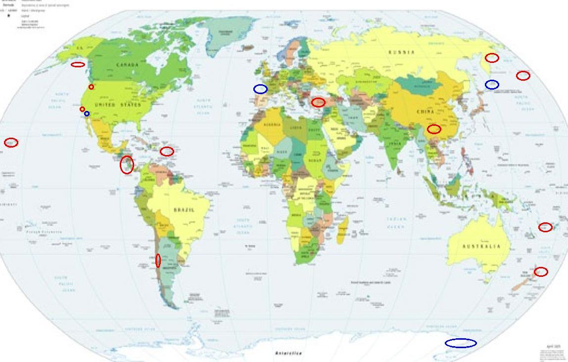
Places to watch.
Good luck to all.
For Saturday, 13 May 2006.
----------------------------------------
Vanuatu area(13.72 S 167.84 E) and then North Island of New Zealand (-38.190 176.250) (I posted Vanuatu for the 11th and this is the second day for the North Island of New Zealand so I would think STRONG for both areas)
----------------------------------------
2006-05-13 19:55:44.3 19.57 S 169.11 E 33 mb 5.3 VANUATU ISLANDS
Reference number: 2568629/G
Universal Time: 16 May 2006 at 10:39
NZ Standard Time: Tuesday, 16 May 2006 at 10:39 pm
Latitude, Longitude: 31.56°S, 179.30°W
Location: 290 km south-west of Raoul Island
Focal depth: 150 km
Richter magnitude: 7.6
Web page: http://www.geonet.org.nz/x2568629g_l.html
(3 extra days)
Gulf of Alaska (STRONG)
----------------------------------------
MAP 2.8 2006/05/12 18:08:54 58.650 -149.808 50.0 GULF OF ALASKA
MAP 2.8 2006/05/13 10:19:14 57.493 -143.648 15.0 GULF OF ALASKA
MAP 2.3 2006/05/13 12:52:53 58.271 -142.801 1.0 227 km (141 mi) SW of Yakutat, AK
El Salvador to Costa Rica
----------------------------------------
(Nothing found)
2 Possibilities - Kurils or Antarctica (New symptom)(Symptom continued next day - STRONG.)
----------------------------------------
2006-05-13 23:53:30.0 56.04 S 27.62 W 100 f mb 5.4 SOUTH SANDWICH ISLANDS REGION
(This may be the right quake for this symptom - I will need a repeat for proof.)
Mt. St. Helen’s (medium)
----------------------------------------
MAP 1.4 2006/05/13 14:03:27 46.195 -122.195 1.1 1 km ( 1 mi) WSW of Mount St. Helens Volcano, WA
MAP 1.8 2006/05/13 20:22:27 46.195 -122.194 0.8 1 km ( 1 mi) WSW of Mount St. Helens Volcano, WA
map 1.8 2006/05/13 19:36:29 46.196N 122.196W 1.2 1 km ( 1 mi) WSW of Mount St. Helens Volcano, WA
NEAR THE EAST COAST OF KORYAKIA, RUSSIA (60.810 165.876) (Symptoms for the usual area but then I think it will also quake in the Aleutian Trench - some of that is happening today on the 10th of May. STRONG.)
----------------------------------------
2006-05-14 06:01:46.7 60.79 N 165.31 E 33 mb 4.6 EASTERN SIBERIA, RUSSIA
2006-05-14 05:16:51.5 60.90 N 165.99 E 40 mb 4.6 EASTERN SIBERIA, RUSSIA
2006-05-15 09:11:14.9 60.68 N 166.43 E 33 mb 4.0 EASTERN SIBERIA, RUSSIA
(2 extra days)
Hawaii (Medium)
----------------------------------------
MAP 1.8 2006/05/13 06:01:29 19.656 -155.097 38.1 6 km ( 4 mi) SSW of Hilo, HI
MAP 1.7 2006/05/13 08:03:03 19.374 -155.232 3.4 8 km ( 5 mi) S of Volcano, HI
MAP 2.4 2006/05/13 20:32:25 19.220 -155.457 7.6 3 km ( 2 mi) NE of Pahala, HI
Turkey (medium)
----------------------------------------
2006-05-13 01:18:00.3 37.11 N 28.55 E 11 MD 3.1 TURKEY
Yunnan, China area (26.43N 101.18E) (MEDIUM)
----------------------------------------
(Nothing found)
Puerto Rico/Virgin Islands
----------------------------------------
MAP 2.7 2006/05/13 04:10:50 19.127 -66.466 15.5 74 km ( 46 mi) N of Tierras Nuevas Poniente, PR
MAP 3.0 2006/05/13 05:05:49 18.266 -64.514 86.7 22 km ( 14 mi) SSW of Spanish Town, British Virgin Islands
MAP 2.7 2006/05/13 05:30:16 19.081 -66.429 38.6 69 km ( 43 mi) N of Breñas, PR
MAP 2.2 2006/05/13 06:41:27 18.094 -67.045 15.5 2 km ( 1 mi) NNW of San Germán, PR
MAP 1.7 2006/05/13 07:13:25 18.278 -66.184 11.3 7 km ( 4 mi) ESE of Naranjito, PR
MAP 3.2 2006/05/13 09:09:06 18.845 -64.124 37.2 24 km ( 15 mi) ENE of Settlement, British Virgin Islands
MAP 2.8 2006/05/13 10:16:01 19.003 -64.494 27.7 35 km ( 22 mi) NNW of Settlement, British Virgin Islands
MAP 2.7 2006/05/13 11:34:31 19.174 -66.432 22.8 79 km ( 49 mi) N of Breñas, PR
MAP 3.0 2006/05/13 12:25:55 18.070 -68.057 84.7 90 km ( 56 mi) WSW of Stella, PR
Little Rock, California area (34.456 -118.036)
----------------------------------------
MAP 1.4 2006/05/13 15:05:40 34.083 -118.445 6.8 3 km ( 2 mi) N of Westwood Village, CA
Possibly Bay of Biscay (New symptom)
----------------------------------------
2006-05-13 10:00:40.8 46.99 N 1.09 W 10 ML 2.9 FRANCE
Possibly Guadalupe Victoria, Mexico (This symptom is overlapping with Vanuatu and since I have already posted for Vanuatu, I will say this is possibly Guadalupe Victoria.)
----------------------------------------
MAP 1.4 2006/05/14 01:54:35 32.764 -116.074 6.8 8 km ( 5 mi) WNW of Ocotillo, CA
MAP 3.2 2006/05/14 01:25:18 32.396 -115.380 3.3 28 km ( 17 mi) WNW of Guadalupe Victoria, Mexico
MAP 1.4 2006/05/14 02:33:33 32.978 -116.251 10.6 22 km ( 13 mi) SSW of Ocotillo Wells, CA
MAP 2.0 2006/05/14 13:50:02 33.167 -116.046 4.3 8 km ( 5 mi) ENE of Ocotillo Wells, CA
MAP 1.4 2006/05/14 19:59:04 32.698 -115.966 7.1 5 km ( 3 mi) SSE of Ocotillo, CA
Coquimbo, Chile area (-30.912 -72.015)
----------------------------------------
2006-05-13 09:42:58.4 18.44 S 71.22 W 60 M 4.6 OFF COAST OF NORTHERN CHILE
2006-05-14 17:04:59.6 20.95 S 68.66 W 80 mb 5.2 CHILE-BOLIVIA BORDER REGION
Peace to all.

posted by Unknown @ 6:12 PM
0 comments
![]()
![]()
