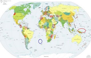
*For Tuesday, 26 December 2006.
LEGEND for OVERVIEW: Size = My surety of area for quake.
Red Circle = Probable quake to STRONG quake.
Triangle = Very Strong/Stronger quake (Usually takes extra days).
Blue Circle, etc. = Uncertainty of symptom area for probable quake.

Plaes to watch.
Good luck to all.
For Tuesday, 26 December 2006.
--------------------------------------
Washington State/Greenwater probably
--------------------------------------
1.7 2006/12/26 07:28:09 47.856N 122.881W 23.4 3 km ( 2 mi) N of Quilcene, WA
1.2 2006/12/26 06:10:32 48.263N 121.935W 13.8 2 km ( 1 mi) SW of Oso, WA
Mt. Hood Village, Oregon (45.348N 122.016W)
(Strong)
--------------------------------------
2.3 2006/12/26 01:44:21 46.510 -122.405 20.4 6 km ( 4 mi) ESE of Mossyrock, WA
2.0 2006/12/27 05:51:42 45.819N 121.909W 8.0 12 km(7mi)NW of Carson River Valley, WA
Mozambique area
--------------------------------------
2006-12-25 10:29:05.4 29.02S 67.14E 33 mb4.9 SOUTH INDIAN OCEAN
(Not very close to where I expected it.)
Myrtletown, CA area (40.743 -123.993)
(Second day symptom - STRONG)
--------------------------------------
(Nothing found)
Nicaragua/Costa Rica (Third day of symptoms -
STRONG) also Frente a La Boquita y Casares
(11.45N 86.64W)
--------------------------------------
06/12/26 19:31:34 12.35N 87.08W 90.7 2.7ML Frente a Poneloya
Turkey (Medium)
--------------------------------------
2006-12-26 01:03:53.5 37.59N 37.42E 5 ML3.6 CENTRAL TURKEY
2006-12-26 03:05:00.1 38.87N 31.67E 5 MD2.9 WESTERN TURKEY
2006-12-26 06:33:06.8 37.10N 29.29E 11 MD2.9 WESTERN TURKEY
2006-12-26 07:48:48.4 39.12N 27.57E 5 MD2.7 WESTERN TURKEY
2006-12-26 14:48:26.8 39.34N 44.04E 5 MD3.4 TURKEY-IRAN BORDER REGION
2006-12-26 14:48:26.8 39.34N 44.04E 5 MD3.4 TURKEY-IRAN BORDER REGION
Germany/Poland
--------------------------------------
2006-12-26 08:33:08.2 51.20N 15.96E 10 ML2.1 POLAND
2006-12-26 12:24:15.0 49.20N 6.80E 10G ML2.0 GERMANY
Switzerland to Central Italy (medium)
--------------------------------------
27Dec2006 23:44:08.9 46.6N 9.8E 5 ML=1.4 M*SED Albulapass / Switzerland 0754
TARAPACA, CHILE (19.23S 69.13W)
--------------------------------------
2006-12-26 06:33:09.3 22.10S 65.48W 166 mb4.5 JUJUY, ARGENTINA
Frente a La Boquita y Casares (11.45N 86.64W)
--------------------------------------
06/12/26 22:33:25 13.12N 90.04W 15.0 4.4ML Frente a El Salvador
06/12/26 19:31:34 12.35N 87.08W 90.7 2.7ML Frente a Poneloya
06/12/26 12:40:28 12.45N 89.06W 20.9 3.8MC Frente a El Salvador
Hawaii (Second day symptom - already at STRONG)
--------------------------------------
2.9 2006/12/26 02:15:28 19.864 -155.674 32.7 15km(9 mi) SE of Waikoloa Village, HI
Ethiopia area (11.49N 43.44E) (I am not sure
what strength to give this symptom. It was
not painful but lasted more than 6 hours as
an awareness and almost squeeze. STRONG)
--------------------------------------
2006-12-30 08:30:51 6.8mB 13.28N 51.11E 10 Eastern Gulf of Aden
2006-12-30 11:09:03 4.6mb 13.99N 51.73E 20 Eastern Gulf of Aden
(4 extra days)
Strait of Gibraltar to Morocco/Algeria
--------------------------------------
2006-12-26 06:57:05.9 36.27N 7.74W 55 mb3.1 STRAIT OF GIBRALTAR
Caroline Islands to Papua New Guinea
to Bismarck Archepelago (Large area of
symptoms - some Strong)
--------------------------------------
2006-12-26 22:56:36.8 2.93N 125.61E 130 mb5.2 KEPULAUAN SANGIHE, INDONESIA
2006-12-27 08:49:35.1 10.64S 123.72E 44 mb4.8 TIMOR REGION, INDONESIA
Possibly SOUTH ATLANTIC OCEAN
(25.84S 2.48W)(Unproven symptom -
STRONG)
--------------------------------------
2006/12/26 00:52:15 15.60 98.79 16 4.1 114 km al SUROESTE de PINOTEPA NACIONAL, OAX
2006/12/26 06:06:29 15.89 98.90 19 4.2 102 km al SUROESTE de OMETEPEC, GRO
2006/12/26 06:48:14 16.14 97.72 15 3.6 34 km al NOROESTE de RIO GRANDE, OAX
2006/12/26 07:38:44 16.66 99.59 4 3.6 26 km al SUROESTE de SAN MARCOS, GRO
2006/12/26 07:55:29 15.78 98.83 5 4.1 104 km al SUROESTE de PINOTEPA NACIONAL, OAX
2006/12/26 13:22:42 16.00 98.67 10 3.8 76 km al SUROESTE de PINOTEPA NACIONAL, OAX
2006/12/26 19:06:59 18.51 103.1525 4.0 30 km al SUR de COALCOMAN, MICH
2006/12/26 20:19:18 15.75 94.42 43 3.9 77 km al SUROESTE de ARRIAGA , CHIS
(Possibly these)
2.9 2006/12/24 11:50:15 36.504 -104.189 5.0 32 km ( 20 mi) E of Maxwell, NM
(Or this)
Peace to all.

