*For Wednesday, 29 March 2006.
LEGEND for OVERVIEW: Size = My surety of area for quake.
Red Circle = Probable quake to STRONG quake.
Triangle = Very Strong or Stronger quake (And usually takes extra days).
Blue Circle, etc. = Uncertainty of symptom area for probable quake.

Places to watch.
Good luck to all.
For Wednesday, 29 March 2006.
----------------------------------------
Xizang to Myanmar area (32.3N 95.1E) (Second day of symptom - Strong)
----------------------------------------
2006-03-29 23:39:08.4 37.05N 95.25E 60 mb5.1 QINGHAI, CHINA
Sumatra (MEDIUM)
----------------------------------------
(Nothing found)
San Francisco
----------------------------------------
MAP 1.0Q 2006/03/29 19:55:33 37.038 -122.135 2.3 1 km ( 1 mi) NE of Quarry near Davenport, CA(Probable quarry explosion)
MAP 2.0Q 2006/03/29 22:06:02 37.324 -122.106 0.0 0 km ( 0 mi) SW of Quarry near Cupertino, CA(Probable quarry explosion)
MAP 1.8 2006/03/30 07:12:58 37.729 -122.546 8.4 4 km ( 2 mi) W of San Francisco Zoo
Possibly Southern Georgia (New symptom)
----------------------------------------
(Nothing found)
Yukon/Northwest Territories (Medium)
----------------------------------------
MAP 4.6 2006/03/29 03:36:52 67.125 -140.970 14.5 NORTHERN YUKON TERRITORY, CANADA
Banda Sea area (7.14S 25.91E) (MEDIUM)
----------------------------------------
2006-03-28 22:26:59 4.8 1.38 N 126.49 E Northern Molucca Sea
31Mar2006 21:14:47.0 3.9N 126.3E 48 M =5.9 M*NEI TALAUD ISLANDS, INDONESIA
(2 extra days)
OFF THE COAST OF COQUIMBO, CHILE (-30.912 -72.015) (Medium)
----------------------------------------
30/03/2006 11:07:36 -30.504 -71.155 55.6 3.8 Mc GUC 3.9 Ml GUC 16 km al NE de Ovalle
29/03/2006 21:57:12 -32.469 -71.363 53 4.4 Mc GUC 4.3 Ml GUC 74 km al NE de Valparaíso
28/03/2006 20:07:51 -32.671 -71.756 36.3 4.3 Mc GUC 4.3 Ml GUC 46 km al N de Valparaíso
28/03/2006 19:52:46 -32.67 -71.826 36.7 4.5 Ml GUC 48 km al N de Valparaíso
Costa Rica area (MEDIUM)
----------------------------------------
06/03/29 23:42:00 11.56N 87.17W 25.1 2.9MC Frente a Puerto Sandino
06/03/29 05:11:13 10.42N 86.26W 3.4 3.6MC Oceano Pacífico de Nicaragua
06/03/29 02:56:02 10.92N 86.38W 6.6 2.9MC Frente a San Juan del Sur
06/03/28 18:39:19 10.80N 86.55W 9.2 3.3MC Frente a San Juan del Sur
06/03/28 17:56:32 9.53N 86.71W 5.0 3.5MC Oceano Pacífico de Costa Rica
COLOMBIA-VENEZUELA BORDER REGION (7.021 -72.749) (2 different areas both - MEDIUM)
----------------------------------------
Galeras, Colombia
Due to an increase in tremor at Galeras beginning on the morning of 28 March, INGEOMINAS raised the Alert Level from 3 ("changes in the behavior of volcanic activity have been noted") to 2 ("likely eruption in days or weeks"). On the 28th, energetic signals and tremor began that had been absent during previous weeks. In addition, seismic instruments detected very shallow low-energy hybrid signals, similar to ones recorded during 1991-1993 when dome emplacement occurred on the main crater's floor.
Source: Instituto Colombiano de Geologia y Mineria - "Report provided courtesy of the Smithsonian's Global Volcanism Program and the US Geological Survey's Volcano Hazards Program."

Central/Southern Italy
----------------------------------------
2006-03-29 16:24:53.0 38.55 N 15.50 E 167 ML 3.1 SICILY, ITALY
2006-03-29 20:20:00.0 37.70 N 13.86 E 10 ML 3.7 SICILY, ITALY
2006-03-30 01:15:00.0 43.68 N 12.29 E 7 ML 2.1 CENTRAL ITALY
Pinnacles area
----------------------------------------
MAP 2.4 2006/03/29 15:36:25 36.520 -121.091 1.9 5 km ( 3 mi) ESE of Pinnacles, CA
MAP 1.5 2006/03/29 15:11:05 36.518 -121.092 2.4 5 km ( 3 mi) ESE of Pinnacles, CA
MAP 1.9 2006/03/29 13:25:38 36.520 -121.091 2.4 5 km ( 3 mi) ESE of Pinnacles, CA
MAP 2.0 2006/03/29 13:21:22 36.520 -121.091 1.9 5 km ( 3 mi) ESE of Pinnacles, CA
MAP 2.9 2006/03/29 13:13:10 36.527 -121.096 1.3 4 km ( 3 mi) E of Pinnacles, CA
From Kazakhstan to Pakistan (Non-specific)
----------------------------------------
2006-03-29 12:34:09.0 43.89 N 65.14 E ML 3.2 CENTRAL KAZAKHSTAN
Honshu, Japan
----------------------------------------
2006-03-29 10:28:39.9 37.09 N 141.49 E 77 M 4.7 NEAR E.CST EASTERN HONSHU
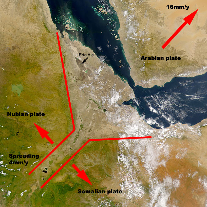
Ethiopia (6.99 N 42.96 E) (VERY STRONG)
http://www.swisseduc.ch/stromboli/perm/erta/airspace-en.html>swisseduc
----------------------------------------
(Nothing found)
Northcentral Iran
----------------------------------------
2006-03-29 02:08:10.5 27.76N 55.60E 18 M3.0 SOUTHERN IRAN
2006-03-29 03:07:46.8 27.70N 55.79E 18 M3.5 SOUTHERN IRAN
2006-03-30 07:28:53 4.7 27.50N 55.10E Southern Iran
MAP 4.7 2006/03/30 16:17:06 33.523 48.731 10.0 WESTERN IRAN
2006-03-30 19:36:17.4 33.71N 48.75E 20f mb5.2 WESTERN IRAN
W of Pokhara (Pokhara), Nepal (28.240 83.890) (VERY STRONG)
http://www.culturefocus.com/nepal.htm>culturefocus

----------------------------------------
2006-03-31 02:48:32.5 33.78 N 48.69 E 18 M 3.5 WESTERN IRAN
2006-03-31 02:42:36.0 33.81 N 48.66 E M 3.1 WESTERN IRAN
2006-03-31 02:12:29.6 33.73 N 48.60 E 8 M 3.1 WESTERN IRAN
2006-03-31 02:08:59.4 33.90 N 48.67 E 9 M 3.1 WESTERN IRAN
2006-03-31 01:31:23.4 33.72 N 48.71 E 20 mb 5.1 WESTERN IRAN
2006-03-31 01:17:00.2 33.63 N 48.76 E 10 mb 5.7 WESTERN IRAN
2006-03-31 02:58:30.6 33.79 N 48.54 E 4 M 3.4 WESTERN IRAN
2006-03-31 05:08:33.0 33.42 N 48.81 E 23 M 3.1 WESTERN IRAN
2006-03-31 05:03:10.8 33.43 N 48.84 E 18 M 3.0 WESTERN IRAN
2006-03-31 05:43:07.7 33.83 N 48.47 E 18 M 3.1 WESTERN IRAN
2006-03-31 07:23:36.7 33.71 N 48.73 E 18 M 3.0 WESTERN IRAN
2006-03-31 09:56:29.4 33.34 N 48.86 E 29 M 3.0 WESTERN IRAN
2006-03-31 09:40:30.5 33.75 N 48.88 E 32 M 3.2 WESTERN IRAN
2006-03-31 09:23:39.6 33.79 N 48.76 E 27 M 3.4 WESTERN IRAN
2006-03-31 07:58:23.6 33.79 N 48.65 E 19 M 3.2 WESTERN IRAN
2006-03-31 11:54:00.3 33.61 N 48.77 E 10 mb 4.8 WESTERN IRAN
2006-03-31 11:43:46.6 33.43 N 47.27 E 18 M 3.6 WESTERN IRAN
2006-03-31 13:50:02.4 33.68 N 48.65 E 6 M 3.1 WESTERN IRAN
2006-03-31 16:02:51.6 33.63 N 48.67 E 18 M 3.1 WESTERN IRAN
2006-03-31 15:30:12.1 33.63 N 48.85 E 18 M 3.5 WESTERN IRAN
2006-03-31 20:04:17.4 33.67 N 48.83 E 18 M 3.0 WESTERN IRAN
(I expected this for Nepal. If these are right for the symptoms I had - I was off by 3 countries!)
Xinjiang, China (40.04 N 82.92 E).
----------------------------------------
2006-03-30 18:31:43.6 33.02 N 93.61 E 60 f mb 4.8 QINGHAI, CHINA
Off the Coast of Northern Peru (8.59 S 81.03 W) (Strong)
----------------------------------------
(Nothing found)
Peace to all.

posted by Unknown @ 2:13 PM
0 comments
![]()
![]()
