*For Sunday, 23 July 2006.
LEGEND for OVERVIEW: Size = My surety of area for quake.
Red Circle = Probable quake to STRONG quake.
Triangle = Very Strong/Stronger quake (Usually takes extra days).
Blue Circle, etc. = Uncertainty of symptom area for probable quake.
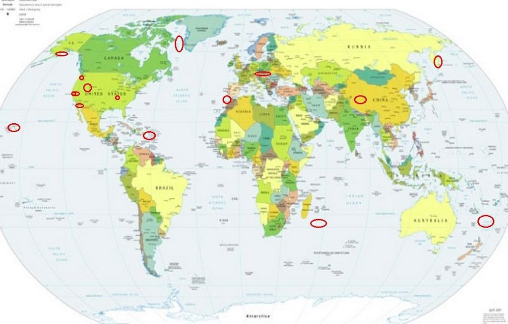
Places to watch.
Good luck to all.
For Sunday, 23 July 2006.
----------------------------------------
Strait of Gibraltar
----------------------------------------
2006-07-23 05:08:03.8 36.45N 1.66E mb 3.6 NORTHERN ALGERIA
2006-07-23 20:17:15.4 35.77N 0.61E 30f Mw 4.4 NORTHERN ALGERIA
2006-07-23 22:13:29.1 35.69N 0.67E 15 mb 4.5 NORTHERN ALGERIA
2006-07-23 23:06:58.1 35.73N 0.79E mb 3.1 NORTHERN ALGERIA
Puerto Rico/Virgin Islands area
(STRONG with volcanics)
----------------------------------------
2.8 2006/07/23 09:46:24 19.093N -64.754W 10.8 61 km (38 mi) NW of Settlement, Anegada, British Virgin Islands
3.5 2006/07/23 09:42:48 19.016N -64.666W 68.6 48 km (30 mi) NW of Settlement, Anegada, British Virgin Islands
3.5 2006/07/23 09:30:04 19.270N -64.639W 24.9 69 km (43 mi) NNW of Settlement, Anegada, British Virgin Islands
2.9 2006/07/23 06:33:23 18.746N -67.291W 0.0 35 km (22 mi) NW of San Antonio, PR
Utah/Nevada (medium)
----------------------------------------
2.0 2006/07/23 03:51:26 38.257 -118.686 0.0 15 km ( 9 mi) WSW of Qualeys Camp, NV
1.1 2006/07/23 07:13:12 38.394 -118.685 10.0 16 km ( 10 mi) SSW of Hawthorne, NV
1.8 2006/07/23 11:58:54 38.348 -118.744 0.0 19 km ( 12 mi) WNW of Qualeys Camp, NV
06/07/23 04:30:00 44.16N 110.21W 5.6 1.5 25.5 mi ESE of West Thumb
06/07/23 04:07:12 39.61N 110.40W 1.5 1.6 4.3 mi NNW of Sunnyside
06/07/23 05:59:10 42.18N 112.09W 10.7 1.4 6.7 mi WNW of Dayton
06/07/23 13:56:35 44.78N 110.46W 3.7 1.6 3.2 mi NNE of Canyon Junc.
06/07/23 19:24:08 39.61N 110.40W 1.6 1.6 4.4 mi NNW of Sunnyside
06/07/23 19:58:26 39.74N 110.74W 0.1 1.3 7.4 mi NE of Helper
06/07/23 20:23:03 39.61N 110.39W 1.2 1.7 4.2 mi NNW of Sunnyside
06/07/23 21:31:29 39.61N 110.39W 1.4 1.3 4.0 mi NNW of Sunnyside
The New Madrid Fault
----------------------------------------
1.8 2006/07/23 05:38:00 45.708N 75.254W 9.0 103 km (64 mi) N of Norfolk, NY
SOUTHWEST INDIAN RIDGE (-36.624 50.443)
(STRONG)
----------------------------------------
2006-07-23 06:17:26.5 28.66N 53.38E 4 M3.3 SOUTHERN IRAN
Southern Xinjiang, China (39.97N 78.75E)
(medium)
----------------------------------------
2006-07-23 08:34:13.0 49.38N 92.28E ML3.7 MONGOLIA
2006-07-23 12:44:37 5.0 33.31N 96.04E Qinghai, China
Pinnacles and East of
----------------------------------------
2.0 2006/07/23 07:32:36 36.448 -121.008 1.2 15 km(9 mi) SE of Pinnacles, CA
CZECH AND SLOVAK REPUBLICS (49.96N 18.29E)
(2 different symptoms - Strong)
----------------------------------------
2006-07-24 02:50:04.0 49.80N 18.62E 4 ML2.1 CZECH AND SLOVAK REPUBLICS
SE.OF LOYALTY ISLANDS (22.81S 171.89E)
(Medium)
----------------------------------------
(Nothing found)
Alaska Peninsula
----------------------------------------
2.9 2006/07/23 14:33:15 55.078 -161.285 50.0 ALASKA PENINSULA
Hawaii (Medium)
----------------------------------------
1.8 2006/07/23 09:52:49 19.337 -155.138 5.5 15 km ( 9 mi) S of Fern Forest, HI
WNW of Guadalupe Victoria, Mexico
(32.338 -115.251)
----------------------------------------
2.2 2006/07/21 02:03:50 32.072 -115.822 6.0 71 km(44 mi) WSW of Guadalupe Victoria, Mexico
2.8 2006/07/21 05:28:00 32.056 -115.547 6.0 49 km(30 mi) WSW of Guadalupe Victoria, Mexico
2.0 2006/07/21 08:15:24 32.129 -115.594 6.0 49 km(30 mi) WSW of Guadalupe Victoria, Mexico
(2 days early)
1.9 2006/07/25 04:14:18 32.400 -115.224 6.0 16 km ( 10 mi) NW of Guadalupe Victoria, Mexico
(2 days extra)
San Francisco area/Berkeley area
(37.857 -122.239) (Medium)
----------------------------------------
1.2 2006/07/24 11:15:39 37.807 -121.942 10.9 2 km ( 2 mi) W of Blackhawk, CA
1.2 2006/07/24 12:10:33 37.810 -121.949 12.2 2 km ( 1 mi) E of Danville, CA
2.3 2006/07/25 04:15:52 37.093 -121.490 2.8 10 km ( 6 mi) E of San Martin, CA
1.3 2006/07/25 13:50:39 37.151 -121.540 8.4 9 km ( 5 mi) NE of San Martin, CA
1.9Q 2006/07/25 18:24:31 37.324 -122.108 0.0 0 km ( 0 mi) WSW of Quarry near Cupertino, CA(Probable quarry explosion)
1.1 2006/07/25 19:57:02 38.020 -122.254 8.5 1 km ( 1 mi) SSE of Rodeo, CA
1.6 2006/07/25 20:27:14 37.366 -122.253 9.2 3 km ( 2 mi) WSW of Portola Valley, CA
(2 extra days)
1.3 2006/07/26 03:26:45 37.946 -122.086 9.4 1 km ( 1 mi) WSW of Pleasant Hill, CA
1.5 2006/07/26 12:14:37 37.902 -122.119 4.2 1 km ( 1 mi) NNW of Lafayette, CA
1.3 2006/07/26 12:29:44 37.907 -122.117 3.7 2 km ( 1 mi) NNW of Lafayette, CA
1.3 2006/07/26 19:11:36 37.902 -122.117 3.3 1 km ( 1 mi) NNW of Lafayette, CA
(3 extra days)
Mt. St. Helen’s
----------------------------------------
1.7 2006/07/23 10:39:26 46.195N 122.197W 0.5 1 km ( 1 mi) WSW of Mount St. Helens Volcano, WA
1.8 2006/07/23 04:03:20 46.197N 122.193W 0.0 1 km ( 1 mi) WSW of Mount St. Helens Volcano, WA
2.4 2006/07/22 21:16:02 46.194N 122.191W 0.0 1 km ( 1 mi) SW of Mount St. Helens Volcano, WA
1.6 2006/07/22 16:50:51 46.195N 122.197W 0.0 1 km ( 1 mi) WSW of Mount St. Helens Volcano, WA
1.4 2006/07/22 11:59:52 46.196N 122.195W 0.0 1 km ( 1 mi) WSW of Mount St. Helens Volcano, WA
1.6 2006/07/22 02:58:14 46.196N 122.196W 0.8 1 km ( 1 mi) WSW of Mount St. Helens Volcano, WA
GREENLAND COAST (69.41N 53.41W)
(Strong)
----------------------------------------
(Nothing found)
Kamchatka area
----------------------------------------
2006-07-24 11:05:36.6 55.31N 160.68E 50 mb3.5 KAMCHATKA PENINSULA, RUSSIA
Peace to all.

posted by Unknown @ 12:41 PM
0 comments
![]()
![]()
