*For Friday, 17 February 2006.
LEGEND for OVERVIEW:
Size = My surety of area for quake.
Red Circle = Probable quake to STRONG quake.
Triangle = Very Strong or Stronger quake (And usually takes extra days).
Blue Circle, etc. = Uncertainty of symptom area for probable quake.
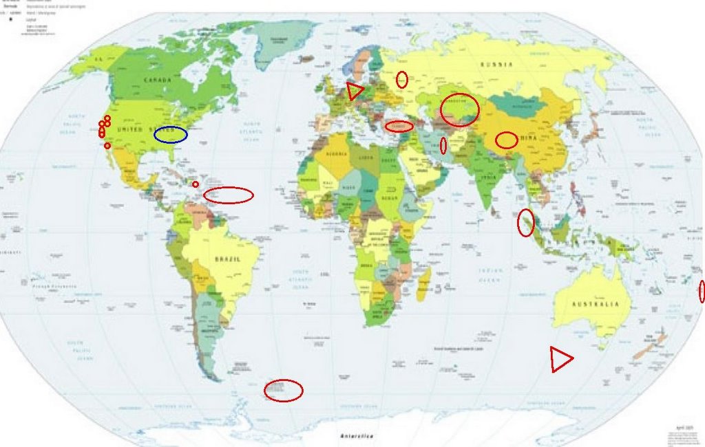
Places to watch.
Good luck to all.
For Friday, 17 February 2006.
----------------------------------------
Parkfield Fault (Medium)
----------------------------------------
MAP 2.2 2006/02/17 00:54:15 36.300 -120.883 5.4 23 km ( 14 mi) NNE of San Lucas, CA
MAP 1.1 2006/02/17 12:46:35 36.835 -121.423 4.8 3 km ( 2 mi) WSW of Hollister, CA
San Francisco (MEDIUM)
----------------------------------------
MAP 1.3 2006/02/16 13:55:11 37.760 -122.567 12.0 6 km ( 4 mi) WNW of San Francisco Zoo
MAP 1.0 2006/02/17 20:42:45 37.834 -122.234 7.4 1 km ( 1 mi) N of Piedmont, CA
MAP 1.4 2006/02/18 02:03:22 37.748 -122.161 3.1 4 km ( 3 mi) N of San Leandro, CA
MAP 1.1 2006/02/18 09:19:02 37.279 -122.176 7.6 11 km ( 7 mi) SSW of Los Altos Hills, CA
MAP 1.5 2006/02/18 12:40:03 37.812 -122.070 12.0 6 km ( 4 mi) SE of Moraga, CA
MAP 3.2 2006/02/18 12:38:16 37.816 -122.070 13.5 6 km ( 4 mi) ESE of Moraga, CA
Moscow, Russia area (STRONG)
----------------------------------------
BALTIC STATES-BELARUS-NW RUSSIA REGION
Origin time Lat Lon Azres Timres Wres Nphase Ntot Nsta Netmag
2006-046:06.50.06.0 55.07 23.41 6.36 0.44 2.03 3 3 3 2.30
BALTIC STATES-BELARUS-NW RUSSIA REGION
Origin time Lat Lon Azres Timres Wres Nphase Ntot Nsta Netmag
2006-046:10.40.31.0 67.70 33.78 6.09 1.34 2.87 6 9 3 2.12
BALTIC STATES-BELARUS-NW RUSSIA REGION
Origin time Lat Lon Azres Timres Wres Nphase Ntot Nsta Netmag
2006-047:10.28.36.0 59.34 26.87 5.15 2.25 3.54 6 7 3 1.99
South Sandwich Islands (STRONG)
----------------------------------------
2006-02-17 12:18:29 5.1 56.67 S 27.68 W South Sandwich Islands Region
2006-02-17 15:49:44 4.6 60.80 S 95.72 W Southern Pacific Ocean
(More West than expected)
Northern Sumatra (2 different symptoms - Strong)
----------------------------------------
(Nothing found)
Turkey (2 different symptoms - STRONG)
----------------------------------------
2006-02-17 00:09:35.7 40.03N 27.92E 15 ML 3.4 TURKEY
2006-02-17 07:09:10.2 40.08N 27.94E 25 MD 2.8 TURKEY
2006-02-17 04:15:35.6 37.21N 28.78E 14 MD 2.9 TURKEY
Alamor, California area (40.218 -121.180) (Medium)
----------------------------------------
(Nothing found)
Tonga area
----------------------------------------
2006-02-17 02:41:43.1 22.81S 171.89E 53 mb4.9 SE.OF LOYALTY ISLANDS
Puerto Rico then Virgin Islands/North Atlantic Ocean (Medium for Virgin Islands/North Atlantic Ocean area)
----------------------------------------
MAP 3.1 2006/02/17 13:16:24 18.465 -64.484 72.4 5 km ( 3 mi) WNW of Spanish Town, British Virgin Islands
MAP 3.2 2006/02/17 16:26:08 18.195 -67.803 102.5 60 km ( 38 mi) WSW of Rincón, PR
MAP 2.5 2006/02/17 21:37:20 18.676 -66.983 23.7 20 km ( 12 mi) NNE of Isabela, PR
The New Madrid Fault (Various areas - possibly as far East as Pennsylvania, though. This was mostly non-specific vibrations.)
----------------------------------------
map 1.7 2006/02/17 17:17:04 36.260N 89.510W 7.2 2 km ( 1 mi) W of Ridgely, TN
map 1.2 2006/02/17 21:01:43 44.801N 74.678W 7.9 25 km (15 mi) E of Norfolk, NY
map 0.9 2006/02/16 18:00:30 41.159N 74.557W 8.5 2 km ( 1 mi) ENE of Hamburg, NJ
map 2.6 2006/02/16 17:43:22 41.160N 74.535W 8.1 4 km ( 2 mi) ENE of Hamburg, NJ
South of Australia (Second day of symptom - VERY STRONG - See 16 February.)
----------------------------------------
(Still nothing for this area - may not show until 21st or later.)
Redding, California or North of (New symptom area)
----------------------------------------
(Nothing found)
Germany (VERY STRONG)
http://www.visionlandscapes.com/Gallery.aspx?Gallery=Germany>Vision Landscapes

----------------------------------------
2006-02-17 12:00:01.2 50.20N 12.67E ML 2.2 GERMANY
2006-02-17 17:51:12.4 49.37N 6.96E 2f ML 4.0 GERMANY
Earthquake Event
Information with high accuracy
Characteristics
* Magnitude: 5.2 M
* Depth: 128 km
Location
* Location (Lat/Long): 49.28 | 6.71
* Country: Germany
* Region: Germany
Time
* UTC/GMT (Greenwich time): 2/17/2006 5:51:15 PM
* Local time: 2/17/2006 6:18:05 PM
Northcentral Iran
----------------------------------------
2006-02-18 11:03:32.1 30.56N 55.77E 30 mb4.8 NORTHERN AND CENTRAL IRAN
Paso Robles, California area (35.626 -120.807)
----------------------------------------
(Nothing found)
Kazakhstan to Kyrgyzstan
----------------------------------------
2006-02-17 10:20:51.0 53.66N 71.86E ML3.1 CENTRAL KAZAKHSTAN
Quinghai, China (33.76N 91.24E)
----------------------------------------
2006-02-17 09:11:16 5.4 37.44N 120.44E Northeastern China
Ensenada, Mexico
----------------------------------------
MAP 1.9 2006/02/18 19:14:51 32.587 -116.780 4.3 14 km ( 9 mi) W of Tecate, Mexico
Peace to all.

posted by Unknown @ 11:43 AM
0 comments
![]()
![]()
