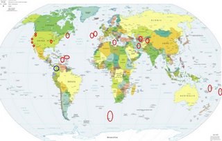
*For Monday, 6 November 2006.
LEGEND for OVERVIEW: Size = My surety of area for quake.
Red Circle = Probable quake to STRONG quake.
Triangle = Very Strong/Stronger quake (Usually takes extra days).
Blue Circle, etc. = Uncertainty of symptom area for probable quake.

Places to watch.
Good luck to all.
For Monday, 6 November 2006.
--------------------------------------
Virgin Islands/Soufrierre area (STRONG)
then Puerto Rico/Caribbean Sea area (STRONG)
--------------------------------------
2.7 2006/11/06 23:57:35 18.818N -67.105W 12.6 36 km (22 mi) N of San Antonio, PR
3.1 2006/11/06 19:33:20 18.849N -64.460W 33.7 20 km (12 mi) NW of Settlement, Anegada, British Virgin Islands
3.3 2006/11/06 08:50:39 18.751N -65.907W 96.8 36 km (22 mi) N of Loíza, PR
2.9 2006/11/06 02:02:26 18.787N -65.163W 57.5 54 km (34 mi) NNW of Charlotte Amalie, Saint Thomas, US Virgin Islands
Digby,NS area (44.53N 66.07W)(Medium)
--------------------------------------
2006/11/05 04:17:34 45.87N 74.77W 5.0* 1.1MN 29 km NE from Saint-Andre-Avellin,QC
2006/11/05 13:40:32 45.87N 74.77W 5.0* 1.4MN 29 km NE from Saint-Andre-Avellin,QC
2006/11/06 04:33:11 46.09N 74.85W 18.0* 1.1MN 20 km W from Saint-Jovite,QC
2006/11/07 02:12:13 52.91N 81.48W 18.0* 2.2MN James Bay.
(Not right on the coordinates.)
Northcentral Iran then (Medium)
Turkmenistan/Uzbekistan area
then TAJIKISTAN (37.96N 72.51E)(Medium)
--------------------------------------
2006-11-05 08:40:19.0 39.21N 72.47E ML3.0 TAJIKISTAN
2006-11-06 04:27:34.5 37.51N 48.96E 36 M3.2 NORTHWESTERN IRAN
2006-11-06 06:23:36.6 36.01N 57.03E 31 M3.1 NORTHEASTERN IRAN
2006-11-06 08:14:41.0 37.91N 72.27E ML4.1 TAJIKISTAN
2006-11-06 09:54:08.0 39.60N 71.56E ML3.2 KYRGYZSTAN
2006-11-07 05:51:50.0 52.66N 71.64E ML3.3 CENTRAL KAZAKHSTAN
2006-11-07 08:45:40.0 39.03N 73.31E ML3.6 TAJIKISTAN
The New Madrid Fault
--------------------------------------
(Nothing found)
Bouvet Island Region (55.13S 2.25E)
--------------------------------------
2006-11-05 06:37:51 5.1 50.45S 115.16E 20 Western Indian Antarctic Ridge
(Close to the right lattitude but way off on the longitude - if right quake.)
NORTH ATLANTIC OCEAN area (41.70N 15.35W)
(STRONG)
then NORTHERN MID-ATLANTIC RIDGE
(46.82N 27.35W)
--------------------------------------
2006-11-07 06:06:56 5.1 2.38N 32.26W 20 Central Mid Atlantic Ridge
(Much more south than expected.)
Vanuatu (Strong)
and then Tonga
--------------------------------------
2006-11-05 02:40:56 5.5 15.69S 175.76W 450 Tonga Islands
06Nov2006 04:39:45.1 18.0S 178.4W600 mb=4.7 M*GSR FIJI ISLANDS REGION
2006-11-06 15:48:14.2 12.23S 167.38E 33 mb5.0 SANTA CRUZ ISLANDS
DODECANESE ISLANDS, GREECE
(36.83N 26.53E) (Felt volcanic - Strong)
--------------------------------------
2006-11-05 09:13:08.8 40.47N 21.91E 12G ML2.4 GREECE
2006-11-05 13:50:51.7 36.48N 28.52E 41 MD2.9 DODECANESE ISLANDS, GREECE
2006-11-05 17:14:58.5 39.72N 13.77E 441 mb5.0 TYRRHENIAN SEA
2006-11-05 21:10:46.4 38.98N 23.35E 8G ML3.0 GREECE
2006-11-05 21:29:01.8 39.02N 23.37E 5 ML3.3 AEGEAN SEA
2006-11-05 22:55:19.5 38.18N 23.96E 15G ML2.9 GREECE
2006-11-07 11:13:36.3 36.05N 18.30E 33f ML5.0 CENTRAL MEDITERRANEAN SEA
2006-11-07 11:13:36.3 36.05N 18.30E 33f ML5.0 CENTRAL MEDITERRANEAN SEA
2006-11-07 04:42:59.1 34.26N 26.52E 10 mb4.2 CRETE, GREECE
San Simeon/Lake Nacimiento area (Medium)
--------------------------------------
1.9 2006/11/05 05:04:30 35.675 -121.133 3.5 6 km ( 4 mi) NE of San Simeon, CA
Possibly Northern Colombia (7.17N 76.16W)
(Unproven symptom - STRONG.)
--------------------------------------
2006-11-05 10:03:50 4.8 8.87S 41.08W 20 Brazil
The Parkfield Fault/Pinnacles and North
--------------------------------------
1.3 2006/11/06 03:36:51 36.662 -121.284 5.6 15 km ( 9 mi) SSE of Tres Pinos, CA
1.0 2006/11/06 04:28:39 37.399 -121.751 5.6 7 km ( 5 mi) ENE of Alum Rock, CA
2.0 2006/11/06 10:57:53 37.349 -121.722 2.5 9 km ( 6 mi) ESE of Alum Rock, CA
1.5 2006/11/06 14:48:04 36.232 -121.135 0.0 2 km ( 1 mi) NNW of King City, CA
1.4 2006/11/06 15:51:35 36.509 -121.090 3.4 5 km ( 3 mi) ESE of Pinnacles, CA
2.1 2006/11/06 16:42:28 36.662 -121.281 4.5 15 km ( 9 mi) SSE of Tres Pinos, CA
1.4 2006/11/06 16:47:05 36.662 -121.280 4.4 15 km ( 9 mi) SSE of Tres Pinos, CA
1.0 2006/11/06 19:03:05 36.660 -121.281 4.9 15 km ( 9 mi) SSE of Tres Pinos, CA
1.6 2006/11/06 19:41:02 36.564 -121.056 9.7 9 km ( 5 mi) ENE of Pinnacles, CA
Mt. St. Helen’s
then Mt. Hood area
--------------------------------------
2.6 2006/11/06 05:34:35 45.516 -122.648 15.7 1 km ( 1 mi) SW of Portland, OR
(Nothing found for Mt. St. Helen's)
Guadalupe Victoria, Mexico area
--------------------------------------
2.2 2006/11/06 19:15:07 32.204 -115.838 8.3 61 km ( 38 mi) SW of Mexicali, Mexico
Peace to all.

