*For Friday, 17 March 2006.
LEGEND for OVERVIEW:
Size = My surety of area for quake.
Red Circle = Probable quake to STRONG quake.
Triangle = Very Strong or Stronger quake (And usually takes extra days).
Blue Circle, etc. = Uncertainty of symptom area for probable quake.
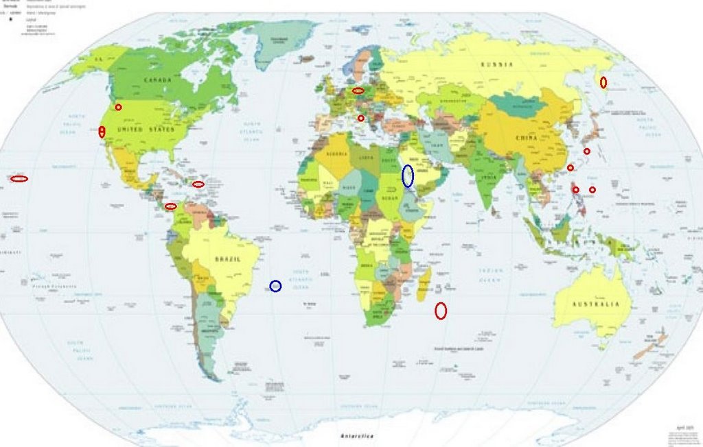
Places to watch.
Good luck to all.
For Friday, 17 March 2006.
----------------------------------------
Taiwan Region (24.1N 122.3E)
----------------------------------------
2006-03-18 19:19:43.9 25.09 N 122.66 E 154 mb 4.8 TAIWAN REGION
Possibly Red Sea area
----------------------------------------
(Nothing found)
The Parkfield Fault (MEDIUM)
----------------------------------------
MAP 1.7 2006/03/17 00:43:53 36.538 -121.117 2.1 2 km ( 2 mi) ENE of Pinnacles, CA
MAP 1.0 2006/03/17 07:29:16 36.587 -121.187 5.0 7 km ( 5 mi) NNW of Pinnacles, CA
MAP 1.5 2006/03/17 06:56:19 36.538 -121.118 2.8 2 km ( 1 mi) ENE of Pinnacles, CA
MAP 2.2 2006/03/17 20:42:53 36.237 -120.804 9.7 23 km ( 14 mi) ENE of San Lucas, CA
Southwest Indian Ridge (33.08 S 56.83 E) (Indication of a deep quake - STRONG)
----------------------------------------
(Nothing found)
Germany/Poland area
----------------------------------------
2006-03-16 05:20:52 3.6 49.30 N 6.75 E Germany
2006-03-16 17:08:55 3.4 51.50 N 16.16 E Poland
2006-03-17 12:00:11.9 50.25 N 12.67 E ML 2.0 GERMANY
2006-03-17 16:34:11.1 51.27 N 16.26 E 10 ML 2.4 POLAND
Mt. St. Helen's (Possible small eruption) (MEDIUM)
----------------------------------------
MAP 2.2 2006/03/17 04:51:37 46.191 -122.181 0.0 1 km ( 1 mi) S of Mount St. Helens Volcano, WA
MAP 2.9 2006/03/17 15:12:17 46.197 -122.190 0.0 1 km ( 1 mi) WSW of Mount St. Helens Volcano, WA
Luzon, Philippines and East of (14.99 N 120.35 E) (STRONG for East of)
----------------------------------------
2006-03-16 21:50:15 5.5 6.88 S 126.04 E Banda Sea
006-03-17 13:07:20 5.8 7.51 S 125.14 E Banda Sea
2006-03-17 14:21:42 5.5 5.34 S 123.14 E Banda Sea
2006-03-18 02:40:14 5.3 6.72 S 129.30 E Banda Sea
(Nothing for the Philippines and I was way off on the East of)
Ryukyu Islands area (Strong)
----------------------------------------
(Nothing found)
Italy (Medium)
----------------------------------------
(Nothing found)
Possibly Trinidade Island in the South Atlantic (A symptom that has never been proven - STRONG)
----------------------------------------
(Nothing found)
Panama/Colombia area
----------------------------------------
(Nothing found)
Puerto Rico area (Strong)
----------------------------------------
MAP 3.2 2006/03/17 07:46:27 18.237 -67.448 85.7 23 km ( 15 mi) WSW of Stella, PR
Hawaii (2 different symptoms - Strong)
----------------------------------------
MAP 1.9 2006/03/17 09:26:43 19.508 -155.451 5.2 23 km ( 15 mi) WNW of Volcano, HI
MAP 2.2 2006/03/17 14:28:33 19.427 -156.304 11.6 40 km ( 25 mi) WSW of Kahaluu-Keauhou, HI
MAP 2.7 2006/03/17 17:34:03 19.419 -155.660 2.5 24 km ( 15 mi) E of Honaunau-Napoopoo, HI
MAP 1.7 2006/03/17 20:47:57 19.195 -155.420 33.3 6 km ( 4 mi) E of Pahala, HI
San Francisco
----------------------------------------
MAP 1.7 2006/03/18 09:12:06 37.810 -122.071 12.0 6 km ( 4 mi) SE of Moraga, CA
MAP 1.6 2006/03/18 10:49:12 37.809 -122.075 11.7 6 km ( 4 mi) SE of Moraga, CA
MAP 2.2 2006/03/18 11:35:45 37.806 -122.077 11.8 6 km ( 4 mi) SE of Moraga, CA
MAP 1.7 2006/03/18 15:58:21 37.436 -121.790 5.7 8 km ( 5 mi) NNE of Alum Rock, CA
MAP 1.0 2006/03/18 20:56:49 37.799 -122.090 10.6 6 km ( 4 mi) SSE of Moraga, CA
MAP 1.2 2006/03/18 23:50:19 37.203 -121.525 4.2 13 km ( 8 mi) NE of Morgan Hill, CA
Kamchatka (STRONG)
----------------------------------------
(Nothing found)
Peace to all.

posted by Unknown @ 2:06 PM
0 comments
![]()
![]()
