*For Sunday, 14 January 2007.
LEGEND for OVERVIEW: Size = My surety of area for quake.
Red Circle = Probable quake to STRONG quake.
Triangle = Very Strong/Stronger quake (Usually takes extra days).
Blue Circle, etc. = Uncertainty of symptom area for probable quake.
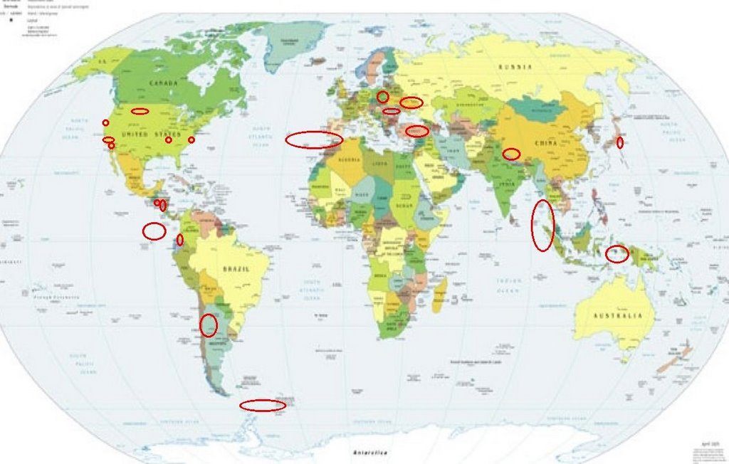
Places to watch.
Good luck to all.
For Sunday, 14 January 2007.
--------------------------------------
Northern East Pacific Rise (10.013 -103.896)
--------------------------------------
2007-01-15 21:19:45.3 4.68S 105.06W 60f mb5.0 CENTRAL EAST PACIFIC RISE
Coalinga, California (36.205 -120.259) (STRONG)
then a larger area (Non-specific)
--------------------------------------
2.3 2007/01/14 13:45:37 35.965 -120.206 21.7 10 km ( 6 mi) SW of Avenal, CA
2.2 2007/01/14 13:41:50 35.970 -120.203 25.6 10 km ( 6 mi) SW of Avenal, CA
2.4 2007/01/14 13:39:59 35.947 -120.170 23.3 10 km ( 6 mi) SSW of Avenal, CA
2.1 2007/01/14 13:09:38 36.008 -120.187 27.1 6 km ( 4 mi) WSW of Avenal, CA
1.9 2007/01/14 13:09:07 35.938 -120.213 17.4 13 km ( 8 mi) SW of Avenal, CA
1.6 2007/01/14 07:00:11 36.338 -120.913 2.3 23 km ( 14 mi) WSW of New Idria, CA
Ecuador/Colombia area
--------------------------------------
(Nothing found)
Near El Salvador (12.57N 89.30W)
then Nicaragua
--------------------------------------
07/01/14 02:59:28 13.36N 87.27W 5.0 2.7MC Honduras
07/01/15 21:29:25 10.96N 86.51W 150.3 2.8ML Frente a El Astillero
07/01/15 18:44:23 12.02N 87.00W 81.4 2.1ML Frente a Puerto Sandino
07/01/15 04:04:37 13.36N 87.13W 100.0 3.1ML Honduras
07/01/15 02:42:47 11.72N 87.88W 11.6 1.8ML Oceano Pacífico de Nicaragua
Montana/Idaho/Wyoming (Yellowstone) (Medium)
--------------------------------------
(There may have been some but I was too late to collect them from the list. I do not know how to find finger quakes that are older than a week on USGS. Sorry.)
Possibly Eastern Ukraine area (New symptom area)
--------------------------------------
(Nothing found)
The Geysers
--------------------------------------
2.0 2007/01/14 18:25:19 38.810 -122.773 0.5 3 km ( 2 mi) ENE of The Geysers, CA
1.5 2007/01/14 12:38:06 38.819 -122.784 1.3 3 km ( 2 mi) NE of The Geysers, CA
1.5 2007/01/14 12:04:26 38.836 -122.795 2.8 4 km ( 3 mi) NNE of The Geysers, CA
1.2 2007/01/14 00:15:25 38.820 -122.793 3.9 3 km ( 2 mi) NNE of The Geysers, CA
Anza, California (33.487 -116.460)
--------------------------------------
1.3 2007/01/14 17:56:18 33.985 -116.989 14.2 7 km ( 4 mi) NNW of Beaumont, CA
1.2 2007/01/14 17:51:40 33.349 -116.852 16.3 1 km ( 1 mi) ESE of Palomar Observatory, CA
COQUIMBO, CHILE (30.18S 71.28W) (MEDIUM)
--------------------------------------
(Nothing found)
Turkey (Medium)
--------------------------------------
2007-01-14 17:01:42.0 38.40N 22.20E ML3.4 GREECE
2007-01-14 16:43:04.5 35.30N 23.22E 50 ML3.8 CRETE, GREECE
2007-01-14 13:57:39.8 38.54N 40.39E 20 MD3.0 EASTERN TURKEY
2007-01-14 10:09:57.8 38.06N 38.77E 5 MD3.5 EASTERN TURKEY
2007-01-14 08:36:16.9 39.28N 41.21E 12 MD3.0 EASTERN TURKEY
2007-01-14 08:27:45.5 40.70N 29.16E 13 MD2.7 WESTERN TURKEY
2007-01-14 07:41:53.7 39.92N 23.23E 10 ML2.8 AEGEAN SEA
2007-01-14 04:39:43.0 38.80N 21.10E ML2.8 GREECE
WESTERN XIZANG-INDIA BDR REG (30.31N 80.47E)
--------------------------------------
2007-01-15 11:23:00 4.8mb 25.96N 75.44E 20 Northern India
MINAHASA, SULAWESI, INDONESIA (0.24N 123.60E)
(Medium)
--------------------------------------
2007-01-14 10:40:51.5 6.89S 129.59E 232 mb4.9 BANDA SEA
2007-01-14 00:47:44.4 4.54N 126.27E 122 mb4.9 KEPULAUAN TALAUD, INDONESIA
2007-01-15 17:25:08 5.0mb 8.22S 127.10E 124 Timor Region
Honshu, Japan area
--------------------------------------
(Posted on 15th)
Romania area (Second day symptom - Strong)
--------------------------------------
2007-01-14 23:04:53.5 43.15N 22.51E 35 ML2.7 SERBIA
2007-01-14 15:35:47.0 42.31N 19.30E 20 ML2.6 MONTENEGRO
2007-01-14 01:50:50.1 42.26N 21.37E 10 ML2.5 SERBIA
Strait of Gibraltar to Azores area
--------------------------------------
2007-01-14 17:58:46.0 40.65N 29.43W ML3.6 AZORES ISLANDS REGION
2007-01-14 22:41:42.2 36.65N 2.65E mb3.3 NORTHERN ALGERIA
Poland
--------------------------------------
(Posted on the 15th)
Northern Sumatra to Andaman Islands
(Second day symptom - Strong)
--------------------------------------
2007-01-15 06:13:38.1 12.84N 92.96E 33 mb4.4 ANDAMAN ISLANDS, INDIA REGION
WSW of Burnsville, NC (35.895 -82.359)
--------------------------------------
(Nothing found)
The New Madrid Fault
--------------------------------------
(Nothing found)
South Sandwich Islands area
--------------------------------------
2007-01-15 07:58:26 5.2mb 61.59S 34.13W 150 Scotia Sea
Peace to all.

posted by Unknown @ 3:31 PM
0 comments
![]()
![]()
