*For Monday, 20 March 2006.
LEGEND for OVERVIEW: Size = My surety of area for quake.
Red Circle = Probable quake to STRONG quake.
Triangle = Very Strong or Stronger quake (And usually takes extra days).
Blue Circle, etc. = Uncertainty of symptom area for probable quake.
Places to watch.
Good luck to all.
For Monday, 20 March 2006.
----------------------------------------
Parkfield Fault
----------------------------------------
MAP 1.0 2006/03/20 00:45:16 36.536 -121.112 4.1 3 km ( 2 mi) E of Pinnacles, CA
MAP 1.1 2006/03/20 16:42:10 36.524 -120.963 1.1 16 km ( 10 mi) E of Pinnacles, CA
The Geysers
----------------------------------------
MAP 1.8 2006/03/20 01:30:57 38.808 -122.790 2.7 2 km ( 1 mi) NE of The Geysers, CA
MAP 2.0 2006/03/20 09:27:01 38.818 -122.810 3.7 2 km ( 1 mi) N of The Geysers, CA
MAP 2.1 2006/03/20 09:00:47 38.833 -122.804 2.7 4 km ( 2 mi) N of The Geysers, CA
MAP 2.3 2006/03/20 11:59:31 38.819 -122.792 4.1 3 km ( 2 mi) NNE of The Geysers, CA
MAP 1.6 2006/03/20 12:42:19 38.787 -122.770 2.4 3 km ( 2 mi) ESE of The Geysers, CA
MAP 1.8 2006/03/20 13:09:39 38.795 -122.762 1.6 4 km ( 2 mi) E of The Geysers, CA
MAP 1.5 2006/03/20 20:08:58 38.793 -122.800 4.2 1 km ( 1 mi) SE of The Geysers, CA
Mariana Islands area (Strong)
----------------------------------------
22Mar2006 12:56:08.7 21.7N 143.2E 33 mb=5.0 M GSR MARIANA ISLANDS REGION
(2 extra days)
Hawaii (Weirdness - coldness - STRONG)
----------------------------------------
MAP 1.9 2006/03/20 07:49:36 19.199 -155.424 32.6 6 km ( 4 mi) E of Pahala, HI
MAP 2.1 2006/03/20 09:45:42 19.369 -155.812 10.3 12 km ( 7 mi) SE of Honaunau-Napoopoo, HI
MAP 1.7 2006/03/20 21:12:20 19.389 -155.283 2.9 8 km ( 5 mi) SW of Volcano, HI
MAP 1.7 2006/03/20 21:40:06 19.376 -155.506 13.5 19 km ( 12 mi) N of Pahala, HI
MAP 1.9 2006/03/20 23:16:40 19.278 -155.468 10.2 8 km ( 5 mi) N of Pahala, HI
Puerto Rico/Virgin Islands area
----------------------------------------
MAP 3.1 2006/03/20 03:05:28 18.609 -64.775 49.7 21 km ( 13 mi) NNW of Little Harbour, British Virgin Islands
MAP 2.7 2006/03/20 12:44:17 19.075 -63.805 26.0 66 km ( 41 mi) NE of Settlement, British Virgin Islands
MAP 3.1 2006/03/20 19:00:28 18.837 -64.826 97.9 47 km ( 29 mi) NNW of Little Harbour, British Virgin Islands
MAP 3.2 2006/03/20 19:17:22 19.218 -64.905 47.2 82 km ( 51 mi) NW of Settlement, British Virgin Islands
MAP 3.4 2006/03/20 20:08:52 19.055 -64.853 81.8 67 km ( 41 mi) WNW of Settlement, British Virgin Islands
Mt. St. Helen's (Indication of a deep quake and second day of strong symptoms - Very Strong)
----------------------------------------
MAP 1.1 2006/03/20 03:25:46 46.198 -122.193 0.4 1 km ( 1 mi) WSW of Mount St. Helens Volcano, WA
MAP 2.4 2006/03/20 14:54:05 46.188 -122.179 0.0 1 km ( 1 mi) S of Mount St. Helens Volcano, WA
MAP 2.3 2006/03/20 22:23:46 46.196 -122.196 0.4 1 km ( 1 mi) WSW of Mount St. Helens Volcano, WA
MAP 1.1 2006/03/20 23:36:16 46.195 -122.194 0.7 1 km ( 1 mi) WSW of Mount St. Helens Volcano, WA
MAP 2.7 2006/03/21 06:47:18 46.198 -122.189 0.0 1 km ( 0 mi) WSW of Mount St. Helens Volcano, WA
MAP 1.0 2006/03/21 08:23:39 46.196 -122.194 0.6 1 km ( 1 mi) WSW of Mount St. Helens Volcano, WA
(Nothing deep)
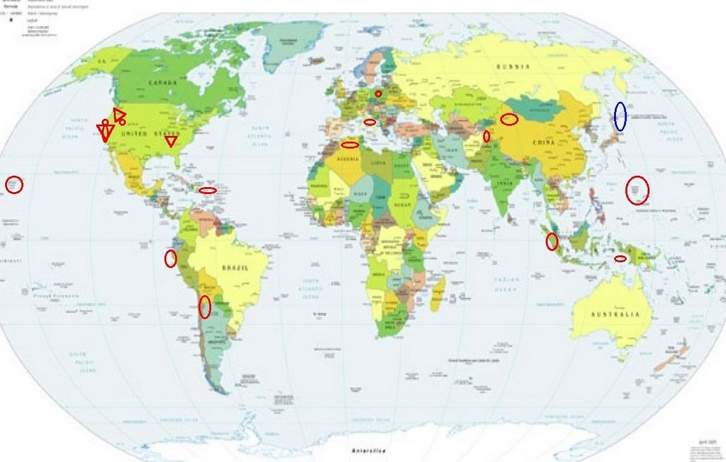
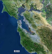
San Francisco (Although nothing much has happened in the San Francisco area so far...17 March...I am getting more and stronger symptoms for San Francisco. I am posting for 20th to 25th as - VERY STRONG.)
http://www.onelang.com/encyclopedia/index.php/San_Francisco_Bay_Area>The Bay
----------------------------------------
(A swarm came in on the 21st and 22nd and I am posting them on the 21st correlations list.)
Timor, Indonesia area (9.51S 126.27E) (Medium)
----------------------------------------
(Nothing found)
Xinjiang, China area (41.42N 83.04E) (MEDIUM)
----------------------------------------
2006-03-20 02:09:04.6 48.78 N 85.20 E 40 ML 4.4 KAZAKHSTAN-XINJIANG BDR REG
Possibly Kurils or Hokkaido area (Right ear tone - unproven)
----------------------------------------
2006-03-19 22:18:36 5.0 46.60 N 134.20 E E Russia-NE China Border Region
2006/3/21
TOKYO (AP)
A volcano in northern Japan erupted early Tuesday, spewing a small amount of ash into the air, the Meteorological Agency said.
Mount Meakandake on Japan's northern main island of Hokkaido, about 890 kilometers (555 miles) northwest of Tokyo, erupted about 6:28 a.m., the weather agency said in a news release.
A column of white smoke up to 400 meters (1,320 feet) high was observed moving toward the southeast.
About 8,500 residents of the nearby town of Ashoro have been advised not to go near the 1,499-meter (4,947-foot) volcano, but no evacuation order has been issued, according to Keiichi Kamada, official of Hokkaido Prefectural Office.
The volcano had another minor eruption in 1998, according to the weather agency.
Japan, which has 108 active volcanos, is among the world's most seismically active countries.
The New Madrid Fault (Very Strong)
http://www.sciencedaily.com/releases/2001/03/010309080443.htm>Glacier thoughts
"``Why earthquakes occur in the middle of plates and where they are likely to occur in the future is a fundamental outstanding problem,`` Zoback says. The New Madrid area sits squarely on top of what geologists call a ``failed rift,`` where hot, molten rock underneath the Earth`s crust once threatened to rise and push apart the North American continent. For some reason, the upwelling stopped and never successfully split the plate. But the process left its signature, Zoback says, creating a unique tension in the New Madrid portion of the North American plate."
http://www.trekearth.com/gallery/North_America/United_States/Midwest/Missouri>Missouri

----------------------------------------
(Nothing found - this is probably still coming.)
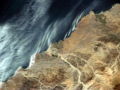
Off the Coast of Peru (STRONG) (Second day symptom for this area so upping it to - Very Strong.)
http://gosouthamerica.about.com/library/blPerspacepix7.htm>Peru
----------------------------------------
(Nothing found - may still be coming.)
Central Italy (42.54N 13.23E).
----------------------------------------
(Nothing found)
Sumatra (MEDIUM)
----------------------------------------
(Nothing found)
Poland
----------------------------------------
2006-03-20 16:46:09.5 50.14 N 18.75 E 10 ML 2.5 POLAND
2006-03-20 20:35:44.7 51.61 N 16.07 E 2 ML 4.2 POLAND
2006-03-20 23:03:14.7 51.40 N 15.96 E 10 ML 2.4 POLAND
Hindu Kush/Pakistan
----------------------------------------
19Mar2006 02:48:55.9 34.5N 73.7E 15 MS=4.2 M*GSR PAKISTAN
2006-03-20 04:33:02.4 36.64N 71.43E 92 mb4.6 AFGHANISTAN-TAJIKISTAN BDR REG
2006-03-20 17:40:48.0 34.98N 73.74E 40 mb5.5 PAKISTAN
2006-03-20 22:41:45 4.7 34.90N 74.06E Southwestern Kashmir
2006-03-20 22:41:42.5 34.90N 73.82E 33 mb5.2 PAKISTAN
2006-03-21 01:15:01.0 34.85N 73.94E 10 mb4.4 PAKISTAN
2006-03-21 06:52:05.8 29.44N 68.28E 33 mb5.0 PAKISTAN
MAP 5.0 2006/03/21 07:08:14 29.384 68.277 10.0 PAKISTAN
Spring City, Utah area
----------------------------------------
MAP 1.7 2006/03/20 00:44:20 39.411 -111.213 2.5 23 km ( 14 mi) WNW of Huntington, UT
MAP 1.6 2006/03/20 02:23:12 39.667 -110.518 2.3 16 km ( 10 mi) NNW of East Carbon, UT
MAP 2.1 2006/03/20 02:56:19 39.607 -110.397 0.7 6 km ( 4 mi) N of Sunnyside, UT
MAP 1.6 2006/03/20 04:40:01 39.715 -110.758 1.4 9 km ( 6 mi) ENE of Helper, UT
MAP 1.6 2006/03/20 03:53:57 39.735 -110.730 3.9 12 km ( 8 mi) ENE of Helper, UT
MAP 1.5 2006/03/20 10:40:45 39.674 -110.508 1.7 16 km ( 10 mi) NW of Sunnyside, UT
MAP 1.4 2006/03/20 11:21:19 38.989 -111.333 3.9 10 km ( 6 mi) NW of Emery, UT
MAP 1.3 2006/03/20 11:43:33 39.666 -110.513 2.6 16 km ( 10 mi) NW of Sunnyside, UT
MAP 1.5 2006/03/20 15:04:52 39.667 -110.517 1.8 16 km ( 10 mi) NNW of East Carbon, UT
MAP 1.2 2006/03/20 16:26:32 39.671 -110.515 1.9 16 km ( 10 mi) NW of Sunnyside, UT
MAP 1.3 2006/03/20 17:49:53 39.606 -110.395 0.8 6 km ( 4 mi) N of Sunnyside, UT
MAP 1.8 2006/03/20 17:43:18 39.608 -110.396 1.1 6 km ( 4 mi) N of Sunnyside, UT
MAP 1.2 2006/03/20 18:44:04 39.663 -110.519 2.3 16 km ( 10 mi) NNW of East Carbon, UT
MAP 1.6 2006/03/20 21:24:12 40.632 -111.361 1.5 7 km ( 4 mi) W of Kamas, UT
MAP 1.8 2006/03/20 21:25:07 39.614 -110.402 1.1 7 km ( 4 mi) N of Sunnyside, UT
MAP 1.7 2006/03/20 22:42:47 39.418 -111.203 11.3 23 km ( 14 mi) WNW of Huntington, UT
MAP 1.8 2006/03/20 23:48:21 39.418 -111.205 4.7 23 km ( 14 mi) WNW of Huntington, UT
(No Spring City)
Chile/Argentina area (Second day but different symptom for this area - Strong.)
----------------------------------------
22Mar2006 11:50:59.1 21.9S 69.0W100 mb=5.1 M*GSR NORTHERN CHILE
(2 extra days)
Northern Algeria area (36.96N 3.38E) (Odd rhythmic symptom.)
----------------------------------------
2006-03-19 21:58:55.3 34.96N 3.17W mb 3.1 MOROCCO
2006-03-19 22:13:26.7 35.07N 3.12W mb 3.2 STRAIT OF GIBRALTAR
2006-03-20 19:44:24.8 36.62N 5.48E 10 mb 5.0 NORTHERN ALGERIA
2006-03-20 21:10:14.4 36.89N 5.25E mb 3.7 NORTHERN ALGERIA
Peace to all.

posted by Unknown @ 1:39 PM
0 comments
![]()
![]()
