*For Monday, 14 November 2005.
Places to watch.
Good luck to all.
For Monday, 14 November 2005.
----------------------------------------
Quebec area
----------------------------------------
2005/11/14 22:44:01 48.37N 78.52W 1.0g 1.9MN GSC Blast, 10 km from Mouska Mine, QC
2005/11/14 19:51:11 46.04N 73.41W 0.0g 1.9MN GSC Blast, Joliette, QC
2005/11/14 17:03:12 45.14N 76.50W 0.0g 1.8MN GSC Blast, 26 km SW from Almonte, ON
2005/11/13 11:02:15 41.81N 81.17W 5.0g 2.3MN GSC Southern Lake Erie
Utah/Nevada
----------------------------------------
map 2.0 2005/11/14 16:43:35 38.484 -118.510 0.0 11 km ( 7 mi) ESE of Hawthorne, NV
map 1.5 2005/11/15 04:29:52 39.710 -110.744 0.0 10 km ( 6 mi) ENE of Helper, UT
map 1.9 2005/11/15 09:21:07 39.080 -119.033 0.0 16 km ( 10 mi) NE of Yerington, NV
(I did not include Spring City, Utah under this post but probably will combine the symptoms in future posts.)
Hawaii (Extremely Strong with eruption)
----------------------------------------
map 2.0 2005/11/14 15:19:12 19.404 -155.394 1.9 17 km ( 11 mi) WSW of Volcano, HI
map 2.6 2005/11/14 16:49:46 19.309 -155.217 3.9 ISLAND OF HAWAII, HAWAII
map 1.7 2005/11/15 08:51:20 19.472 -155.714 10.0 18 km ( 11 mi) E of Honaunau-Napoopoo, HI
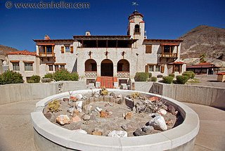
Scotty's Castle, California to Mammoth Lakes (Non-specific but muscle jerks and that is new to me...STRONG)
Death Valley National Park
Scotty's Castle
Some say Death Valley Scotty paid for the Castle with gold from his secret mine. Others say his partner Chicago millionaire Albert Johnson built it. Whose castle was it really? Perhaps you can decide while strolling through the grounds on your own, or maybe while joining a park ranger on a 1939 living history tour of the mansion.
Regardless of the source of his income, Death Valley Scotty certainly remains Death Valley's greatest legend for his flamboyant and outrageous character. Born Walter Scott in 1872, he ran away as a young boy from his home in Kentucky to join his brother on a ranch in Nevada.
The rest of the story here: http://gorp.away.com/gorp/resource/us_national_park/ca/his4_dv.htm Scotty Story
http://www.danheller.com/images/California/DeathValley/ScottysCastle/MainView/Slideshow/img1.htmlPictures

----------------------------------------
map 1.2 2005/11/14 19:13:38 37.473 -118.822 2.0 16 km ( 10 mi) SW of Toms Place, CA
map 1.2 2005/11/15 00:20:14 37.557 -118.809 8.0 11 km ( 7 mi) W of Toms Place, CA
map 1.0 2005/11/15 02:41:25 37.632 -118.849 7.6 11 km ( 7 mi) E of Mammoth Lakes, CA
map 1.2 2005/11/15 14:21:44 37.597 -118.821 8.1 13 km ( 8 mi) WNW of Toms Place, CA
map 1.9 2005/11/15 14:19:45 37.533 -118.820 7.4 13 km ( 8 mi) WSW of Toms Place, CA
map 1.3 2005/11/15 12:00:47 37.472 -118.825 1.7 16 km ( 10 mi) SW of Toms Place, CA
Alaska Peninsula
----------------------------------------
map 3.9 2005/11/14 13:16:20 56.300 -157.000 10.6 ALASKA PENINSULA
New Madrid Fault/Missouri
----------------------------------------
map 1.6 2005/11/14 03:30:56 35.620 -90.380 7.6 4 km ( 3 mi) WNW of Lepanto, AR
map 2.2 2005/11/15 15:46:24 35.540 -84.380 19.3 3 km ( 2 mi) NW of Madisonville, TN
Southern to Central Alaska (Very Strong)
----------------------------------------
map 2.5 2005/11/14 15:56:36 63.623 -147.189 1.0 CENTRAL ALASKA
map 2.8 2005/11/15 15:48:46 60.024 -145.493 20.0 SOUTHERN ALASKA
North Atlantic near Azores (2 different symptoms for this area - Strong)
----------------------------------------
2005/11/13 15:33:29.3 36.49 N 11.16 W 24 mb3.6 NORTH ATLANTIC OCEAN
Port Angeles, Washington area then close to top of Olympic Peninsula (STRONG for Port Angeles area and Medium for Olympic Peninsula)
----------------------------------------
map 1.3 2005/11/14 15:05:18 47.085N 121.876W 11.4 16 km (10 mi) SSE of Enumclaw, WA
(I seem to have Mt. St. Helen's symptom right but the rest of Washington State is still causing me problems. Nothing for the areas I posted for.)
Germany/Poland (Medium)
----------------------------------------
2005/11/13 12:31:24.4 51.37 N 16.22 E ML2.3 POLAND
2005/11/13 18:27:55.7 49.21 N 6.80 E 2 ML2.7 GERMANY
2005/11/15 01:58:32.0 49.38 N 6.97 E 2 ML3.6 GERMANY
2005/11/15 13:43:56.0 49.27 N 6.94 E 2f ML3.1 GERMANY
2005/11/15 20:59:21.7 51.18 N 15.97 E 4 ML2.6 POLAND
Switzerland
----------------------------------------
(Nothing found)
British Columbia (Medium)
----------------------------------------
2005/11/15 14:15:01 51.33N 131.09W 10F 3.4 219 km SSE Sandspit BC
2005/11/15 02:17:44 49.54N 127.30W 26 1.3 88 km W Gold R. BC
2005/11/14 22:59:44 53.77N 132.33W 5 1.1 30 km SSW Masset BC
Honshu, Japan area
----------------------------------------
2005/11/14 21:38:49.9 38.15 N 144.95 E 10 mb7.2 OFF EAST COAST OF HONSHU, JAPAN
(I did NOT get a large enough symptom for this quake to be this big - unless I missed something.)
Possibly Mammoth Lakes also (Still waiting for this new symptom to play out and prove itself. I should know by this day where this symptom belongs.)
----------------------------------------
(Came in as Spring City, Utah...I think...posted the quakes on the 13th list - biggest day of symptoms.)
Tonga to Cook Islands
----------------------------------------
2005/11/15 03:34:46.6 20.44 S 173.97 W 33 mb5.3 TONGA ISLANDS
South of Jawa, Indonesia (STRONG)
----------------------------------------
(Nothing found)
Mt. St. Helen's (Medium)
----------------------------------------
map 2.6 2005/11/14 07:26:09 46.196 -122.190 0.1 1 km ( 1 mi) WSW of Mount St. Helens Volcano, WA
map 1.4 2005/11/14 17:36:14 46.213 -122.188 1.8 2 km ( 1 mi) NNW of Mount St. Helens Volcano, WA
Southern Italy/probable Mt. Etna eruptions (STRONG)
----------------------------------------
2005/11/14 11:17:48.0 40.48 N 15.16 E 10 ML2.9 SOUTHERN ITALY
South Sandwich Islands Region
----------------------------------------
MAP 4.7 2005/11/14 12:57:30 -43.810 41.529 10.0 PRINCE EDWARD ISLANDS REGION
(Much further East than I thought.)
Ethiopia to Gulf of Aden (Medium)
----------------------------------------
(Nothing found)
Off the Coast of Peru (Medium)
----------------------------------------
2005-11-13 23:18:54 5.3 19.17 S 69.77 W Northern Chile
(Not off the coast)
Turkey
----------------------------------------
2005/11/14 01:55:45.6 38.16 N 26.57 E 4 MD3.3 AEGEAN SEA
2005/11/14 05:34:33.2 38.18 N 26.70 E 3 MD2.9 AEGEAN SEA
2005/11/14 12:10:55.8 38.19 N 26.66 E 26 MD3.2 AEGEAN SEA
2005/11/14 13:11:22.1 38.24 N 26.57 E 17 MD3.0 AEGEAN SEA
2005/11/14 15:32:35.6 38.46 N 31.90 E 13 MD2.9 TURKEY
Peace to all.

