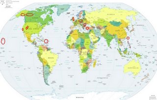
*For Saturday, 8 July 2006.
LEGEND for OVERVIEW: Size = My surety of area for quake.
Red Circle = Probable quake to STRONG quake.
Triangle = Very Strong/Stronger quake (Usually takes extra days).
Blue Circle, etc. = Uncertainty of symptom area for probable quake.

Places to watch.
Good luck to all.
For Saturday, 8 July 2006.
----------------------------------------
Hawaii area
----------------------------------------
2.6 2006/07/08 02:57:33 19.212 -155.593 3.4 12 km (7 mi) W of Pahala, HI
2.8 2006/07/08 20:31:11 19.346 -155.065 7.3 16 km (10 mi) SSE of Fern Forest, HI
Utah and Nevada
----------------------------------------
2.0 2006/07/08 09:09:03 38.303 -118.744 0.0 19 km ( 12 mi) W of Qualeys Camp, NV
1.8 2006/07/08 17:18:40 37.997 -118.678 0.5 37 km ( 23 mi) SSW of Qualeys Camp, NV
1.8 2006/07/08 21:03:54 39.444 -119.624 0.0 16 km ( 10 mi) SE of Sparks, NV
06/07/07 02:00:19 39.74N 110.74W 0.1 1.5 7.4 mi NE of Helper
06/07/07 02:20:40 39.71N 110.78W 9.7 1.2 4.1 mi NE of Helper
06/07/07 04:10:55 39.45N 111.21W 5.2 1.8 14.6 mi ESE of Mount Pleasant
06/07/07 15:10:27 39.61N 110.39W 1.2 1.4 4.2 mi NNW of Sunnyside
06/07/07 16:09:11 39.61N 110.40W 1.7 1.6 4.4 mi NNW of Sunnyside
06/07/07 17:31:24 39.61N 110.39W 1.1 1.6 4.4 mi NNW of Sunnyside
06/07/07 19:20:40 37.97N 112.52W 1.7 2.3 10.9 mi NW of Panguitch
06/07/07 20:20:50 39.61N 110.39W 1.3 1.6 4.2 mi NNW of Sunnyside
06/07/07 21:22:41 38.80N 112.18W 0.9 1.5 5.4 mi WNW of Richfield
06/07/07 22:48:07 39.71N 110.59W 1.8 1.3 13.9 mi NNE of Wellington
06/07/07 23:57:53 40.75N 112.05W 9.9 2.0 4.2 mi NNE of Magna
06/07/07 02:22:40 44.63N 109.98W 19.0 1.5 20.1 mi ENE of Fishing Bridge
06/07/07 04:18:28 44.63N 110.00W 14.8 2.2 19.2 mi ENE of Fishing Bridge
06/07/07 07:44:23 44.63N 109.99W 13.0 2.5 19.7 mi ENE of Fishing Bridge
06/07/07 18:16:09 44.13N 110.57W 6.1 1.4 19.9 mi SSE of West Thumb
06/07/07 18:33:03 44.12N 110.56W 2.5 2.1 20.7 mi SSE of West Thumb
06/07/08 00:45:52 39.61N 110.40W 1.4 1.7 4.2 mi NNW of Sunnyside
06/07/08 04:37:15 39.61N 110.40W 1.5 1.4 4.3 mi NNW of Sunnyside
06/07/08 05:22:05 39.61N 110.39W 1.1 1.6 4.3 mi NNW of Sunnyside
06/07/08 05:23:32 40.75N 112.04W 8.7 1.8 4.2 mi NE of Magna
06/07/08 18:01:11 41.93N 112.56W 2.9 1.1 24.0 mi SSW of Malad City
06/07/08 18:13:50 39.71N 110.78W 9.2 1.1 4.1 mi NE of Helper
06/07/08 21:01:44 39.61N 110.39W 1.1 1.5 4.2 mi NNW of Sunnyside
06/07/08 23:28:53 39.61N 110.40W 1.3 1.7 4.3 mi NNW of Sunnyside
06/07/08 07:01:12 44.63N 109.99W 18.2 1.3 19.8 mi ENE of Fishing Bridge
Parkfield Fault/Probably center
----------------------------------------
2.8 2006/07/07 12:31:55 36.002N 120.551W 13.0 16 km (10 mi) NW of Parkfield, CA
1.8 2006/07/08 19:32:42 36.036 -120.595 1.3 21 km ( 13 mi) NW of Parkfield, CA
1.1 2006/07/09 17:06:27 35.941N 120.628W 8.4 18 km (11 mi) ENE of Bradley, CA
2.5 2006/07/09 17:01:50 35.960N 120.511W 13.1 10 km ( 6 mi) NW of Parkfield, CA
Puerto Rico/Virgin Islands (Medium)
----------------------------------------
2006/07/07 03:52:56.21 19.725N 66.518W 25.2 3.2 D Puerto Rico Trench
2006/07/07 05:27:09.51 18.304N 63.762W 7.4 3.0 D Leeward Islands
2006/07/07 05:28:42.37 18.968N 67.870W 7.1 3.1 D Septentrional Fault Zone
2006/07/07 06:23:58.87 18.506N 65.125W 23.5 2.3 C Virgin Island Platform
2006/07/07 06:25:40.03 18.596N 66.126W 76.9 2.7 C Northern Puerto Rico
2006/07/07 11:10:54.28 18.476N 67.219W 10.9 1.8 C Northwest Puerto Rico
2006/07/07 16:21:51.16 17.965N 67.102W 11.4 2.0 C Southwest Puerto Rico
2006/07/08 03:55:24.30 18.919N 65.180W 24.8 2.8 C Sombrero Fault Zone
2006/07/08 04:03:52.53 18.878N 65.174W 16.0 3.0 D Sombrero Fault Zone
2006/07/08 06:23:47.70 18.975N 67.940W 7.3 3.1 D Septentrional Fault Zone
Poland/Germany (MEDIUM)
----------------------------------------
2006-07-07 23:28:28.8 51.17N 15.90E ML2.3 POLAND
2006-07-08 06:35:42.0 51.35N 16.14E 10 ML2.5 POLAND
2006-07-08 07:14:07.6 49.16N 6.86E 5 f ML2.6 GERMANY
2006-07-08 15:56:34.3 51.17N 15.82E ML2.4 POLAND
2006-07-09 11:16:44.3 51.49N 16.06E 10 ML3.2 POLAND
Southern Alaska
----------------------------------------
2.5 2006/07/08 07:29:08 61.500 -150.105 50.0 SOUTHERN ALASKA
2.6 2006/07/08 16:00:05 61.148 -150.725 10.0 SOUTHERN ALASKA
3.1 2006/07/08 18:16:40 60.661 -142.844 1.0 SOUTHERN ALASKA
2.8 2006/07/08 18:09:21 60.079 -152.760 100.0 SOUTHERN ALASKA
Romania area (MEDIUM)
----------------------------------------
2006-07-08 03:58:17.0 45.74N 26.67E 80 ML3.6 ROMANIA
United Kingdom (51.31 N 1.22 W)
----------------------------------------
2006 07 05 11 44 39.8 49.655 -0.701 493.7 -26.4 0.0 2.5 EXPL - ENGLISH CHANNEL
2006 07 05 10 21 11.8 49.601 -0.604 500.9 -32.3 0.0 2.3 EXPL - ENGLISH CHANNEL
(3 days early)
2006 07 09 21 09 49.5 56.162 -4.901 219.9 700.4 1.6 1.5 LOCHGOILHEAD,S'CLYDE
Turkey (Medium)
----------------------------------------
2006-07-08 06:09:17.7 39.40N 33.11E 5 MD 3.3 TURKEY
2006-07-08 23:08:41.8 37.49N 42.38E 5 MD 3.7 TURKEY
2006-07-09 05:23:23.5 37.84N 33.91E 14 MD 3.3 TURKEY
2006-07-09 10:07:25.6 39.29N 28.22E 17 MD 3.1 TURKEY
Taiwan area (22.03 N 121.97 E) (Medium)
----------------------------------------
(Nothing found)
Yukon Territories/Northwest Territories
----------------------------------------
2006/07/07 08:39:39 62.01N 136.35W 1.0* 2.2ML 154 km NE of Haines Jct.,YT
Peace to all.

